Email me at midwesternmeso (AT) hotmail [DOT] com

Please note: All images and videos on this blog are copyrighted by myself and may not be used without written permission. Any persons or entities who do not seek written permission will be held liable for copyright infringement(s) and will be subject to monetary compensation not to exceed $150,000 USD. (In pursuant to 17 USC Section 504(b) and (c), 17 USC Section 505.)

Friday, November 20, 2009

Hi

It's been awhile since I've posted; I've been pretty busy as usual lately and haven't had time to post much. I'll probably be shutting this blog down within the next few months and will be creating a better-designed one on a new site/blog, so when that is all completed and finalized, I'll post the link on here. I'm hoping to own the Canon 5D Mark II by January/February and ditch my other cameras and lenses (minus the 100-400L) for the Canon 17-40L, the 24-105L (or 24-70L) to compliment the new camera...and am very excited about it.

Here are a few new photos I've recently processed and another reason I can't wait to ditch this POS Sigma 17-70 lens, which fails me nearly every time;

Virga

Virga

Virga

I'll still be updating this blog till the new one is up...

Friday, September 25, 2009

Supercell and Tornado Timelapse

I finally got around to uploading all of the "Aurora" footage, I forgot how much we filmed before the actual tornado. We actually ran out of tape halfway through the Aurora tornado and you'll probably see where on there, but Darin was quick to the draw, so we only lost a few seconds. I really love our suction mount for our video camera that we purchased this year, it eliminates a lot of handheld shakiness and allows for some great time lapses. Next year, we plan on using this same camera and mount, and adding the amazing Sony FX1000 for better quality footage...having the old camera for wide angle structure time lapses and the FX1000 for the handheld zoomed stuff.

This supercell, before the infamous Aurora tornado, was oh-so-close to putting down a tornado in the city of Grand Island, which wouldn't have been good for their somewhat decent populated area, and fortunately didn't. We filmed an occluding meso that produced brief funnels beneath a wall cloud on the east side of Grand Island in the Wal-Mart parking lot, as it approached us about 1/2 - 1 mile to our west. We ran into Mike Hollingshead, saw Scott McPartland and Dave Lewison as well, who were also filming the show over Grand Island.

I would have had more time lapse footage, after the first scene you'll see, but for some reason that suction mount wasn't on tight, or the wind was moving my car and mount side to side, and it was rather annoying, so I left it out.

This took forever to render in Pinnacle, BTW. It only allows a 5x speed, so I had to chop each scene, then render it as the original .m2v file...which only wrote 1-3 frames per second...and each scene probably had 10,000 frames. So then I'd render it that way, then have to render it once again to get it to 10 x, before finally rendering the entire project. Fun stuff. The video isn't in it's native resolution mainly because Vimeo only allows me 500 mb, and the native resolution for this file was 700 mb. So I had to take it a notch down to 1200 x whatever instead of 1440 x 900 (1080i). And then vimeo resizes it to like 640 x 360. It still looks good, much better than any other format.

I'd embed the video on here, but they won't allow you to view it in HD other than their site, so here's the link to the video. I've also enabled it so that anyone can download the original source video on there, and the file is huge at 425 mb, but well worth it vs. the smaller version on vimeo.

Wednesday, September 23, 2009

Top Storm Photos of 2009

Even though there might be a small chance for severe weather in the next week or two, I thought I'd post my favorite storm photos of 2009. I was lucky enough to capture some decent shots in 2009, especially tornadoes. And despite the crappy year that a lot of chasers have had, we've had probably our best year yet...intercepting tornadoes in every month from March until July. Here is a link to last year's top photos.

A 'firenado' back on March 6th, almost as good as the real thing up close:

Firenado

April 26th, near Roll/Crawford, OK:

Roll Oklahoma Tornado

May 6th, 2009 in Linn County, KS a brilliant sunlit wall cloud and rainbow beneath a low-topped supercell...one that didn't even make it into the reports, but is forever etched into my mind:

Linn County Low-Topped Supercell + Wall Cloud

May 30th, Clinton Lake Dam, KS, Lightning shot with the moon setting underneath the updraft :

Clinton Dam Lightning + Moon

June 15th, 2009 near Kinsley, KS:

06152009_02web

June 17th, amazing structure just west of Grand Island, Nebraska (wish I were just about 2 miles further east) :

Grand Island, Nebraska Supercell

June 17th, the Aurora, Nebraska tornado as it begins to cross back north of the highway...a few miles west of Aurora:

Aurora, Nebraska Tornado

June 20th, Princeton Kansas 'mothership' supercell which produced several, weak, brief tornadoes, but the structure stole the show:

Princeton, KS supercell

Monday, September 07, 2009

Storm Chasers Show

Reed Timmer + Aurora, Nebraska Tornado

Here is a preview:


Here's a fact you probably didn't know about Reed: He paid for his new vehicle out of his own pocket!

Brandon Ivey and Matt Hughes will be on the show this year too, who are a couple of chaser friends near the Wichita, Kansas area. Brandon is a stand-up, laid-back guy who I always give hell to about how close he seems to get to tornadoes after dark (via radar). Matt is also a great guy and together, make solid forecasts on tricky days and seem to always bag the good stuff.

Despite the crappy year for most(not for us!), there will be some unbelievable footage on the show. Reed and crew nailed every single major day this year (April 26, April 29, May 13th, June 5, June 15th, June 17th) and took direct hits from tornadoes on 3 of those days...2 of those...they were the first ever to scan the vertical wind shear inside of a tornado. Data collected from all of these intercepts, including the radar data, will eventually help save lives in the future from tornadoes.

In other news, I have just found out via printing at whcc.com that my monitor is way off on calibration. So if your monitor is calibrated correctly, my images probably seem very dark. To fix this problem, I'm calibrating it today with a ridiculously expensive program, so that I can print some photos in the future.

Monday, August 24, 2009

Lawrence, Kansas Lightning Photos

Shot these back on the 9th/10th and was one of the rare chances I've had shooting lightning (and nothing spectacular either). There never seemed to be a night where there were training storms around the KC-Lawrence area where I could go out and shoot for hours like there was last year...and if there was, I couldn't either shoot or the lightning was embedded within the rain cores.

To me, shooting lightning really takes no skill at all, other than keeping the rain off of your lens (which was tough this night as a small amount of mist would require me to wipe it off after each shot). I just judge the brightness of the bolts and how close they are, stop it down as desired (these were between f/5.6 - 9.0 on Tv mode), then fire off 30 second exposures. If you're lucky enough to not have any rain, then you could use a cheap shutter release cable, then set your camera to continuous shooting. And having that thing on, you could just walk away as it fires 30 second exposures off, continuously, so you don't miss a bolt. Luck and the right storms are what makes great lightning photos, great.

lawrencelightning02web

lawrencelightning04web

lawrencelightning03web

lawrencelightning07web

I handheld this one and got lucky:

lawrencelightning05web

I've been doing a lot of fishing lately with luck from time to time and have decided I need a boat badly. I plan on purchasing one over the winter hopefully to use in the early spring and for summer (obviously not much between April, May and June ;) ).

There's not much hope for severe weather in the next 10 days either as the current long range models are showing. I'm pretty anti-hurricane as the eye candy appeal isn't as great as it is with supercells. I could careless to chase one any time soon or even learn more about them. Wind...lots of wind...for hours isn't my cup of tea. If I wanted to experience that, I'd drive into squall lines more often! It seems as though hurricane chasing is more of a survival-of-the-fittest among those who chase them. Yawn. Just give me a slow-moving, striated supercell in Western Kansas on any day and I'll take that over a Cat 5 cane over New York City.

Thursday, August 13, 2009

Perseid Meteor Shower 2009

A friend and I went fishing a couple of nights ago on the evening the Perseid Meteor shower peak was supposed to happen (August 11-12). I caught 8 catfish, he caught zero :). Anyways, couldn't really see any near the Spring Hill lake we were at and left there about 11 p.m. and headed back out at 12 a.m. for the "big show" on top of the dam at Melvern Lake about an hour SW of here. One has to get away from the light pollution in major metro areas for the best viewing. So that looked like an ideal spot to view them and for the most part was. Unfortunately, a half moon rose around 10, and really killed the potential for seeing really bright ones.

Nevertheless, I caught 5 on the camera, shooting at 1600 ISO (800 wouldn't show up) at f/2.8. I tried 1600 ISO at f/4 on the old XT with the Sigma 10-20 lens and caught nothing. It was super nice out, light breeze, 70 degrees, no clouds, only a moon that destroyed some great meteor potential and forced me to shoot shorter exposures while loading up my 4 gig SD card quickly. The Xsi battery died after about 3 hours of shooting, so I had to switch to the XT for about 45 minutes (I'm never prepared lol).

Just before dawn, I was setting up for the northern horizon because I knew it would be sweet to get one with some morning light in it. As I was setting up, Derek yelled to look up and an earth grazer shot clear across the sky from the NW to where it ended in the NE. It was the best one of the night, figures.

And last night, I was outside for maybe 20 minutes and saw at least 5 incredible, fireballs from the city, which were brighter than most I saw the night before. According to others, last night was much better for viewing the Perseids. Sigh. Maybe next year I'll be more prepared and try to choose a better location with something cooler for the foreground. Here are a few shots from 1 a.m. - 5:30 a.m. on August 12th.

Full size, no crop at 17 mm:

Perseid Meteor Shower

~ 75% crop on a different (more faint) one:

Perseid Meteor Shower

~ 50% crop with two meteors in the same shot:

Perseid Meteor Shower

Our viewing area from the dam:

Perseid Meteor Shower

I shot some decent lightning photos around midnight on the 10th that I'll be adding onto here sometime in the next week or so.

Tuesday, August 11, 2009

Photo of the Day, New HD Tornado Video

newaurora01web

Taken just west the Iams pet food plant (which was partially hit by the tornado) just west of Aurora, Nebraska on June 17th. The tornado slowly wraps in rain as it ropes out in front of us, and is shot at 10 mm. It still is mind-blowing of all of the chasers on this tornado on Spotter Network alone, yet only Jeff Snyder and ourselves reported it via it (we reported it twice). Makes you wonder why anyone uses this program other than, "Look at me guys, I'm on Spotter Network!"

Then April 26th, Roll/Crawford, Oklahoma tornadoes in HD is below (click on the HD button). I've been slowly working on a DVD that should be available sometime by the first of October of this year's chases, plus Greensburg tornado in 2007, Quinter, Manhattan tornadoes in 2008 and other dates that aren't coming to mind at the moment.

Thursday, July 30, 2009

Photo of the Day, Chasing Tomorrow

06292009_02web

I'm really running out of photos to post for this daily thing already, or ones I think are good enough to make this...but here's one I took a month ago out on the Clinton Dam near Lawrence, Kansas. I haven't taken hardly any photos in the past two weeks, haven't really had the desire to.

Tomorrow looks good for chasing in Western Kansas, and I'll likely be chasing it depending on tonight's runs. At worst, it looks like a good supercell or two somewhere in extreme Western Kansas. I'll just be glad to be back out on the road and that feeling you get in your stomach before a chase...

Wednesday, July 22, 2009

Storm Photos of the Day

June 20th, Near Princeton, Kansas. Dealt with fog on my lens quite a bit, was a real bitch to keep off.

June 20th

June 20th

Sunday, July 19, 2009

Saturday, July 18, 2009

Storm Photos of the Day

June 7th east of Savannah, Missouri, tornado-warned storm. No tornadoes, gigantic hail larger than softball was witnessed in Oregon, Missouri about 30 minutes prior.

06072009_04web

July 3rd 2 m. east of Concordia, KS.

07032009_01web

Friday, July 17, 2009

Storm Photo of the Day/Week

07082009_01web

I figured since I'm not fond on writing or summarizing much, I'll keep the blog updated with a new picture or two of storms I've photographed this year either daily or weekly (likely in between). When more time allows, I'll write more if I find the time or will.

July 8th south of Garnett, KS. I made it south with under 60 seconds to spare watching rainbands scream ahead of me and kicking up a lot of dust along the gust front, which is unusual given the amount of vegetation/tree cover this time of year in E. KS. I drove back through the area I escaped from and found 20+ powerlines down or snapped, a straw field completely flattened and numerous old trees snapped due to 80-100 mph straight-line winds along US 169 for about a 2 mile stretch. I reported and was in contact with the TOP NWS several times, debunking public reports of strong rotation in the storm. I could barely stay ahead of this thing as it moved due south at almost 50 mph. Left it near Mildred, KS and made it back to Olathe by 6 and went fishing. NWS damage survey and info is here.

Then further south somewhere near Mildred, KS.

07082009_02web

Saturday, July 11, 2009

June 20th Account, More June 17th Photos/Video, June 15th Photos

On June 20th, a warm front extended over parts of Central Kansas during the day with a lot of cloud cover and convection still ongoing from the warm air advection regime the night before, so I held little hope in chasing this day due to extensive cloud cover limiting instability, but the shear looked great for C/E. Kansas. With yet another cap bust in Iowa 2 days prior, and still high off of the June 17th Grand Island/Aurora supercell and tornado, I blew the day off for the most part. Darin, on the other hand, didn't and intercepted a storm that trekked from Wichita to where he intercepted it near Emporia. He called me telling me the structure was amazing, then called back again to say he saw a brief tornado...which I relayed to the NWS in Topeka. I then flew out the door and intercepted it near Princeton. I could see a funnel cloud off to my SW, so I again called the NWS in Topeka and gave them the play-by-play as it unfolded. At one point, the funnel extended 7/8ths of the way down and I was sure there was ground circulation somewhere and it warranted a brief touchdown report. As I was on the phone, I told the gentleman to hold on, so I could get some proof and by that time, it had began to rope out and formed a new area of rotation just to the east. That's where this video starts.


A couple of pictures of it shortly after the video:

Princeton, KS supercell

06202009_15web

And then as it weakens towards sunset:

Princeton, KS Supercell

A few pics of a wall cloud that I was 99 percent sure was heading towards being outflow dominant on June 15th (video is in my previous blog entry below). Taken west of Kinsley, Kansas.

06152009_02web

06152009_01web

06152009_03web

And finally, more June 17th Aurora Video and another photo, below. Next year, I plan on owning the Canon 5D Mark II with an assortment of "L" quality lenses so I can get around the noise factor and shoot higher quality photos. Darin is planning on purchasing the Sony FX1000 for better low light and higher quality video. More blog entries coming and additional photos I've yet to process sometime this summer.

This is a timelapse (and damage footage) of the Aurora Tornado shortly after the first video I posted in my previous blog entry.


06172009_11web

Wednesday, June 24, 2009

June 17th Aurora, Nebraska Tornadoes


The supercell (below) as the new updraft formed and strengthened dramatically right before our eyes just a few miles west of Grand Island. We hung back a little ways at this point to get some structure shots as it wasn't close to producing a tornado.

Quick Note: These photos/videos are copyrighted by myself and any unauthorized use will be prosecuted to the fullest extent of the law, regardless of the party or parties involved.

Grand Island, Nebraska Supercell

Reed Timmer (below) as he looks on, still in shock, from taking a direct hit from the tornado (and can be seen in the video driving by, then tail lights as it forms in front of us). His outer window was broken out (bullet-proof window could not be pulled up in time), spraying glass into his face and others riding in the Dominator (aka SRV - Storm Research Vehicle).

Reed Timmer + Aurora, Nebraska Tornado

Another of the tornado later on:

Aurora, Nebraska Tornado

More later, I've been extremely busy lately. I also intercepted on Saturday two brief tornadoes near Princeton, Kansas and was on the phone with the TOP NWS most of the time, but did manage to snap a lot of photos and video.

Thursday, June 18, 2009

June 15th and June 17th Tornadoes

I have little time to write as I'm getting ready to head to Iowa to see if we can't make it 3 chases in a row with tornadoes...I'll let the video and pictures speak for themselves.

June 15th, 2009 Edwards County, KS - From Kinsley to Macksville, Kansas.


June 17th, 2009 Between Grand Island and Aurora Nebraska. (Darin shot this)


I was actually supposed to chase with Reed Timmer today to get some shots of him in action, but as our 2009 luck would have it, the opportunity presented itself last night. I have so many photos to process in the coming weeks, it isn't funny...insane structure and photos of TVN's SRV getting hit by the tornado (along with video). I don't usually get this excited, but last night was one to remember forever.

Wednesday, June 10, 2009

Fabian Guerra, 6/7/2009 Chase Report

Edit: Tornado pictures today in Nevada County, Missouri (Russel Parsons)

As Darin and I were busting in West Central Iowa this past Saturday, we learned that a fellow chaser, Fabian Guerra passed away on his way to pick up another chaser in Des Moines the night before. According to the police report, a deer jumped out in front of him, causing him to swerve across the median and then proceeded to hit a semi. I knew Fabian as one of the first chasers in the community and met him on a couple of occasions, once in 2005 and the night of the Greensburg tornado in 2007. We also chatted quite a bit in an old storm chaser chatroom about upcoming chases. Dennis Sherrod has set up a memorial fund, which you can donate to here. He will be missed.

On Sunday, Darin, Lexi, Eric and I jumped on a pair of supercells, that failed to produce anything other than extremely large hail from Pawnee City, and the second from Oregon, MO eastward. Here's a video of my car being destroyed by copious amounts of mostly 2" hail with a few baseballs towards the end near Pawnee City. We were trapped in the hail core thanks to some freaked out farmers who were trying to back their horse trailers into a farm nearby. I couldn't get around them for several minutes as we could hear the hail roar and it cost me 2 new cracks and hundreds of dents into my car.


Here are a few shots of the first supercell (Pawnee City, NE), I have yet to process any from the other.

06012009_01web

06012009_02web

06012009_03web

Yesterday was a big bust, with a cold outflow boundary that fooled us into thinking it wasn't cold. The storm we were on displayed supercell structures, a couple of brief, tiny funnels and for the most part, looked cold and outflowish from the getgo.

Thursday, June 04, 2009

Lightning Photos + More Roll/Crawford Oklahoma Tornado Photos

I was half asleep in bed at midnight on the 31st when I saw lightning flashes along the apartment next door. Checked radar and noticed some storms firing along a retreating cold front (?) or a moisture axis (?), or perhaps it was the WAA regime along a stalled front (but was sure it settled much further south of Lawrence) . I briefly checked SPC's mesoanalysis and saw that Lawrence was right on the northern end of 2000 j/kg of MUCAPE and a dewpoint difference of about 10-12 degrees along this boundary.

I zipped to the Clinton dam where Darin, Lexi and I sat in lawn chairs shooting photos for almost an hour and a half. The one and only close CG we saw is below and was shot at 10 mm. The first updraft had some decent structure as you can see (but was better after). If you look closely on the reflection of the water just to the left of the strike, there are 4 fisherman on the shore there. The half moon just happened to be under the updraft base and luckily was rain-free. Shot at my usual, lazy 30 sec exposure, ISO 200 and f/4. Darin, 9 times out of 10, is usually the one who pulls the sweet lightning shots, but my 2009 luck was with me again. There really wasn't much lightning at all for the last 30 minutes we were there as the storms weakened, but of course pulsed back up after we had left.

Clinton Dam Lightning + Moon

I'm just as lazy at processing photos as I am blog entries, so here are a few more shots from April 26th in Roger Mills county, Oklahoma.

First funnel we could see that lasted only about 20 seconds, no ground circulation was visible from our vantage point. Taken at 20 mm or so. I should just ditch my Sigma 17-70 any more as this UWA is starting quarterback every chase now and there hasn't been much need for the 17-70.

Roll, Oklahoma Funnel

Then about 30 seconds after the first tornado formed:

Roll, Oklahoma Tornado #1

Then a not-so-great shot out of the window for the second (or third depending on who you ask) tornado. I had to bump both cams up to 800 ISO again, which can be a noisemaker. If I had a full frame camera, like many other chasers possess, I could step up the quality to another level. So if anyone reading this would like to purchase me the Canon 5d Mark II, I'd probably let you!

Roll Oklahoma Tornado #2

Now it's time to blow off a little steam by ranting on a Douglas county resident in which I was blessed to have crossed paths with .

Old man in Lawrence last week. I passed a new, silver Mercedes Benz SUV last week casually, on cruise control @ 79 mph about 2 miles east of Lawrence. I noticed he had a bumper sticker on it which read, "Arrogance: When Yes We Can turned into I won." So immediately I think this guy and I probably wouldn't be best friends forever. So I think, is he a successful small business owner who hires illegal aliens for cheap labor yielding huge profits, yet votes against illegal immigration? Or, is he some corporate executive who recently laid off 20 of his employees to make sure he still had enough cash in accounts payable to help continue to feed his addiction for his high-class call girls, or, the pointless, monthly business meetings which are centered at the top tourist attractions across the globe? Who knows.

I've now slowed down to 60 mph as I'm entering east Lawrence off of K-10 and notice Dick Cheney's #1 fan riding immediately behind me and is on my ass, not the 10-15 foot stuff, the 2-3 foot stuff. This makes for braking safely, for the posted 45 mph, nearly impossible now. I gently push my brakes, which instantly throws him into a rage, as he swerves over into the right lane to pass, then subsequently cuts me off purposely to get in front of me. He's now breaking the law at 20 mph over. Road rage is very contagious at this point, so I punch it, showing him the more skilled way, of riding someone's at 65 mph in a 45 (Yep, I'm breaking the law now too).

Five years ago, without hesitation, this guy's new Mercedes SUV would have had a custom-made, size 13 shoe souvenir engraved into the driver's side door. But, I elected to even things differently, watching him panic then trying to lose me for a good mile. He finally ducked into a gas station at the last second and I continued on. So if you're reading this, piss up a rope buddy!

We're off to Colorado tomorrow, not thrilled again for this weekend's setup, but it beats any pattern we've been in, in the last month. Probably be a week or two of cap busts from Mother Nature for her grand finale of a not-so chaser friendly year. When summer rolls around I hope to have more time processing photos.

Tuesday, May 26, 2009

May 13th, 2009 Kirksville, Missouri Tornado

We changed our original target of SE KS/ NC OK to NC Missouri based off of the 18z RUC/satellite where an outflow boundary was present and sfc winds were backed to the southeast from Chillicothe to Kirksville, MO. Given the weak flow aloft further south (where extreme instability was present) and sfc winds SW and parallel to the advancing cold front, it made our 2 p.m. decision an easy one as we left KC.

We probably played around with the storms to the south, where the Kirksville supercell would develop, too long. We lost our data connections north of Brookfield, which didn't matter other than us not being able to see how the storms were developing. We heard the tornado warning issued for the storm to our north, so we took off after it. About 5-10 minutes later there were reports from storm chasers that a tornado was on the ground and we could see something wrapped in rain about 10 miles to our north through the trees, occasionally. We entered the western outskirts of Kirksville as the warning was extended into the city of Kirksville, but never heard tornado sirens in the town for the 7 minutes we were there trying to get west on the highway. That's where the video starts below. As we re-entered Kirksville to catch up, again, there were no sirens going off on the north side of town as another extremely rain-wrapped tornado has already claimed two more lives in North Kirksville.


Here is a google map I've made showing our locations. Andy Fischer has a very detailed analysis of the Kirksville environment here, which I highly recommend reading.

In the video, you can hear me tell Darin to report the tornado several times via SpotterNetwork but we were denied west of Kirksville thanks to no data again. But thankfully, we were able to successfully do it east of Kirksville as our second consecutive poor decision nearly cost us serious injuries from flying debris. Sometimes shit happens, as it does to all chasers. But you'll never see me hypocritically criticize another's decisions or accuse them of trying to get the money shot, because the ones who do, are the envious, competitive and narcissistic ones. We still are very thankful and learned a lot from our poor decisions, which thankfully didn't cost us or anyone else their lives.

A persistent ridging pattern over the Central US for the past 10 days or so has resulted in numerous flame wars within the chaser community concerning chaser behavior, getting close, and opinions regarding the future of the rest of the season. It's amusing to say the least and the same old personalities keep pushing their redundant, hypocritical propaganda and empty prophecies foreseeing the future of storm chasing. I'm glad I'm not in this hobby for the social aspect, because there are numerous socially-dysfunctional nerdy characters (and noobs!) with big egos, who I'm glad I don't have to see in person on a regular basis. The new trend among chasers now is accusing everyone else of being an "SPC chaser" or bashing the SPC...more amusement.

Darin and I have been fishing the past 5 nights in a row, which helps ignore this boring pattern. There might be a few opportunities this next week or so, so we'll likely be out there, but the tornado chances seem small, which is fine by me.

Saturday, May 09, 2009

More 5/6 Photos & 5/7 Chase Account

I finally got around to processing a few more photos from Wednesday and Thursday's chases. Wednesday ended up being the better day, but Thursday produced decent LP, low-topped structure (again) and a nonstop lightning barrage for nearly 2 hours.

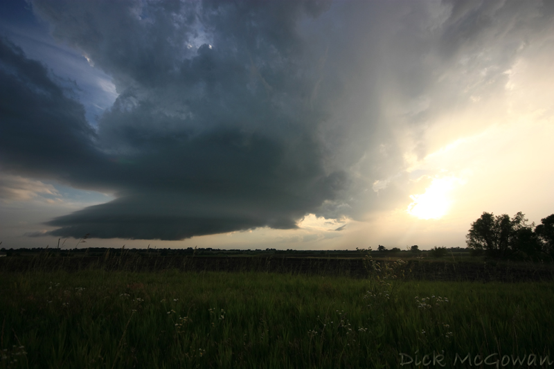
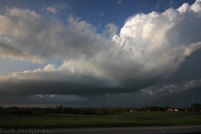
Below is a photo of the western updraft on Wednesday (there's one outside of the photo to the left). It was about 20 minutes after the first tiny reflectivity return that showed up on radar.

5_6_09_03web

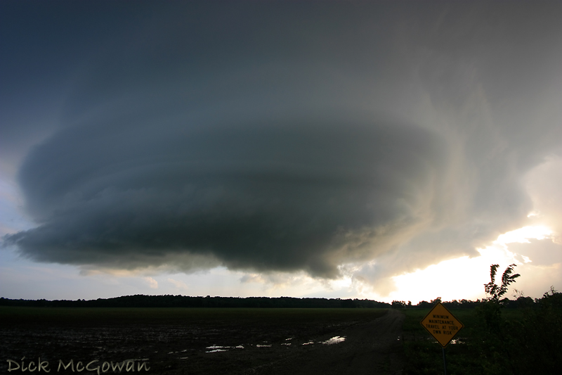
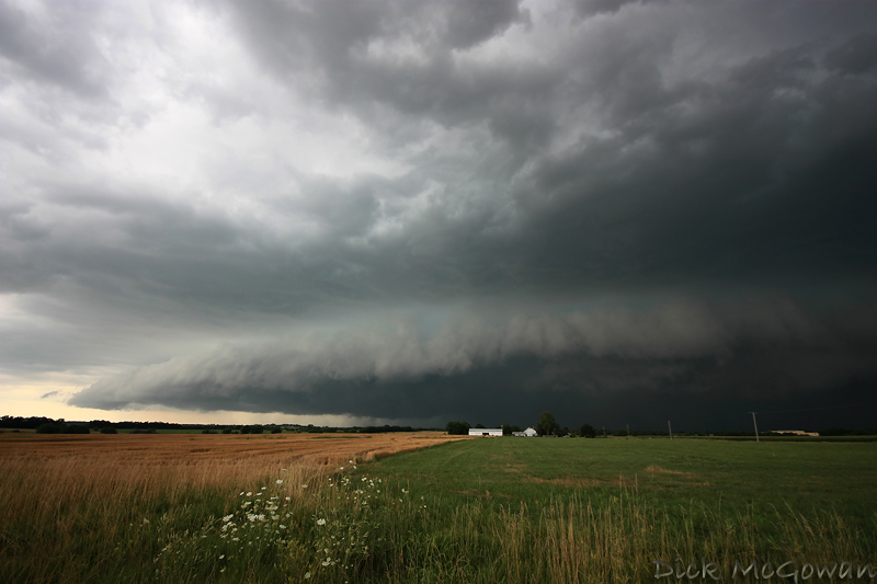
We move south and east from Paola while these two cells begin to finally strengthen! We watch it for a bit then reposition south again while looking back to the northwest at this (below).

5_6_09_04web

At first, it looked kind of elongated, high-based and a little outflow-ish, but we noticed an inflow band forming and feeding in from the southeast. The sun is just enough in the way to make the dynamic range, to shoot photos, a real bitch at this point. About 10 minutes later the base begins to look a little more round (below).

5_6_09_05web

In the photo above you can barely make out that inflow band located at the top right of the photo, which is always a good sign!

We drop south to get out of the precip and about 15 minutes later we pull off on some county road to get a closer look. There are a LOT of trees in Linn County, KS, and the roads/hills are nearly as bad as Missouri, which of course is only 20-30 miles to our east :).

5_6_09_09web

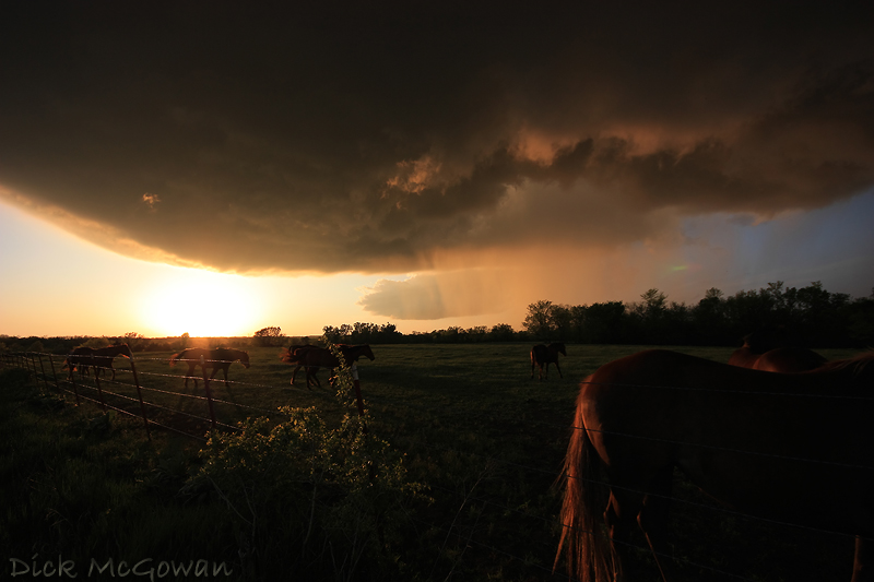
The horses paid no attention to the oncoming storm and were more concerned with us than it. In the photo above, you can see the ghosting (green/red flare) in the picture from having to aim near the sun.

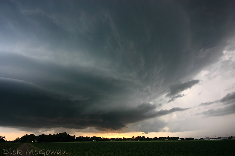
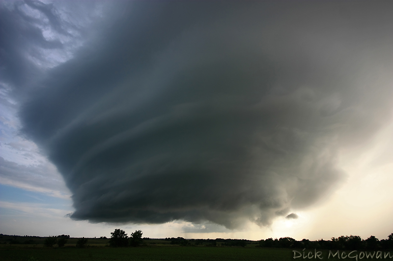
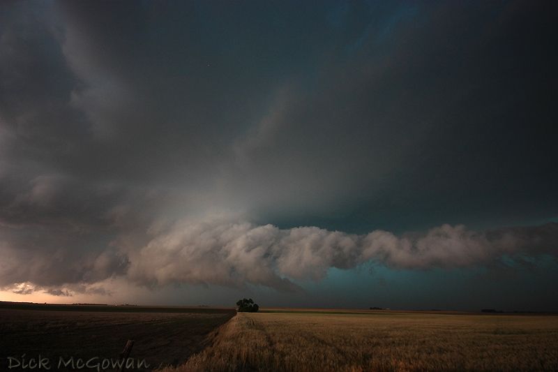
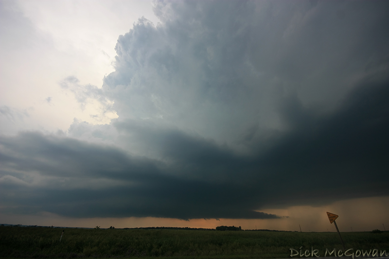
The lighting is pretty much spectacular at this point, displaying a full spectrum of colors. About 10 minutes later, to the right of the image (above), is a huge tree row which we can barely see above, (looking north) but notice what looks like RFD cutting in slowly and a lot of scud being pulled up into the updraft.

5_6_09_10web

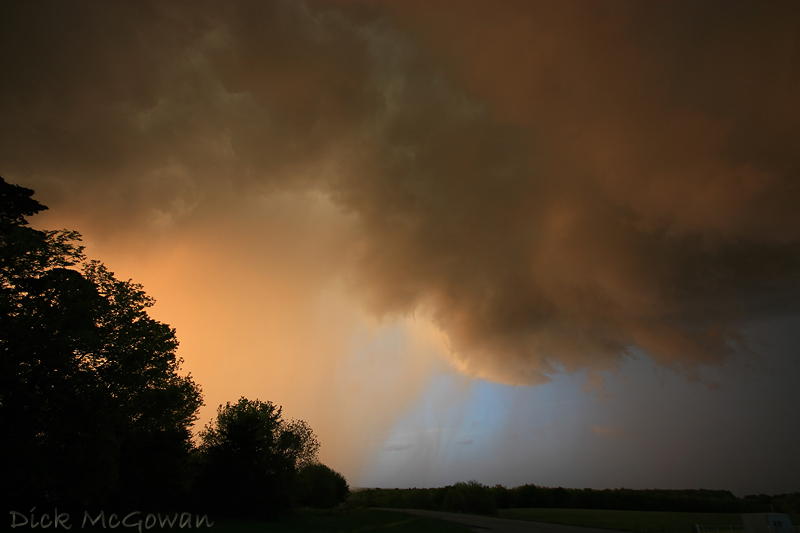
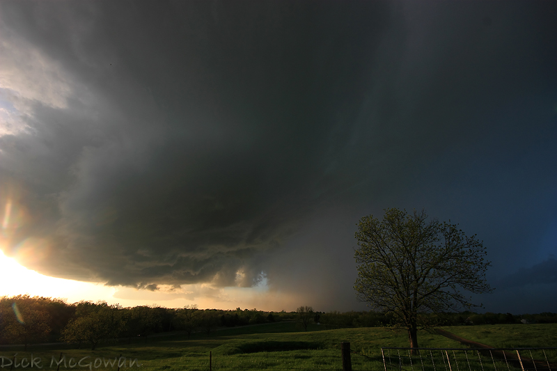
Notice the blue skies behind the updraft/precip core. Behind us, thousands...millions of bright red raindrops are gently falling from the sky, making the scene very surreal. All of these shots, BTW are at 10 mm, so we're a lot closer than it appears.

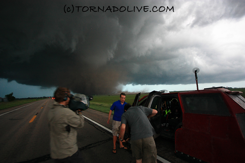
About 3 minutes later, the photo I posted in my previous blog post of the wall cloud is now visible. There's hardly any rotation at this point, just a lot of scud being pulled in rapidly to our east...as we head east. Below, I snapped this photo while driving, a few moments later.

5_6_09_11web

We pretty much drove underneath it (we wouldn't have, had we not felt it was safe to) continuing east as it moves southeast. We're getting into heavy rain east of the developing wall cloud and were surrounded (a full 360 degrees) by a mesmerizing, deep reddish hue of everything...trees, rain, grass, etc. Thanks to that, we lost focus of our road options and missed our south road option. We had just started to turn back around and noticed these, once harmless, rain curtains being forced 180 degrees rapidly back to the west. It was making me nervous because our view of the wall cloud was now obstructed by them. But luckily, we made it south out of the rain and noticed that the wall cloud was now rotating fairly decent and tightened up a couple of times.

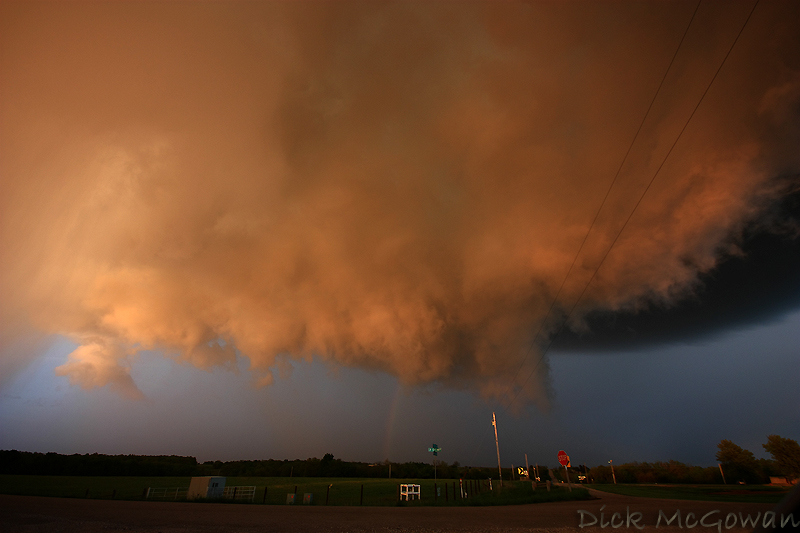
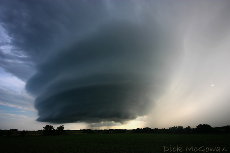
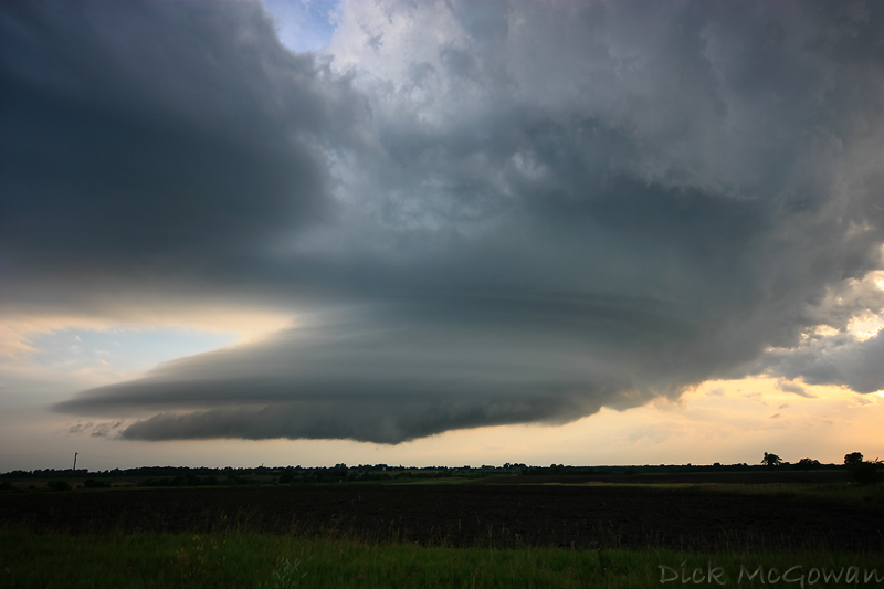
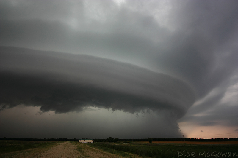
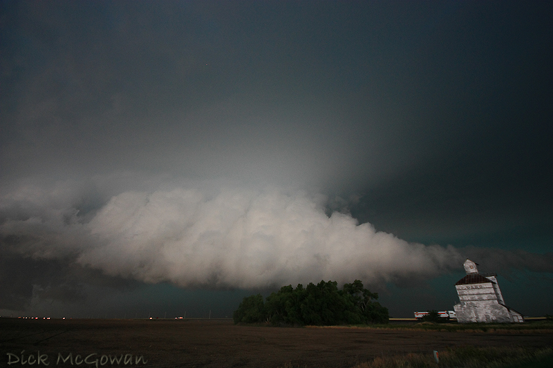
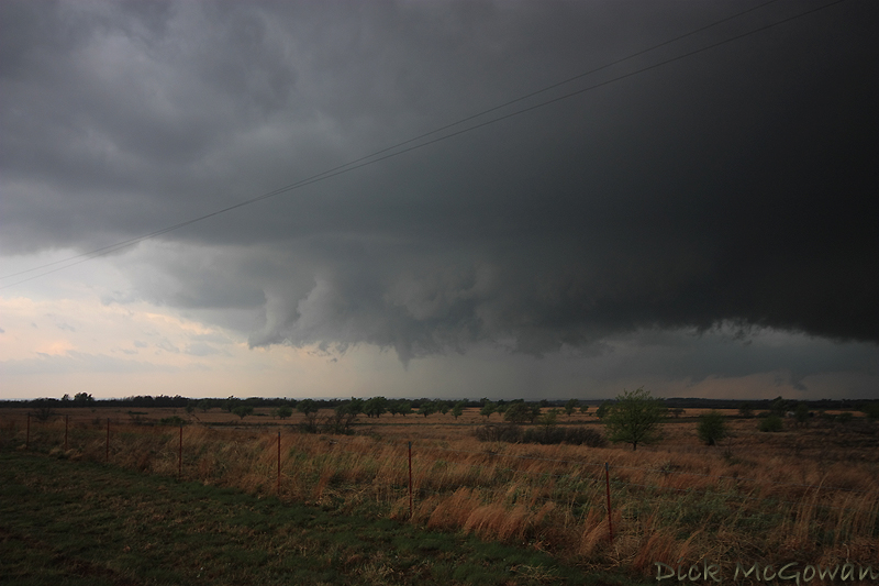
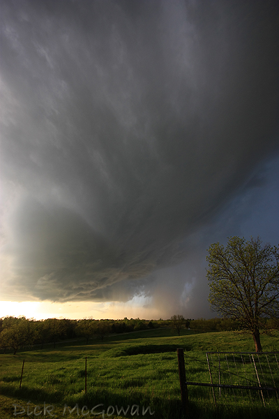
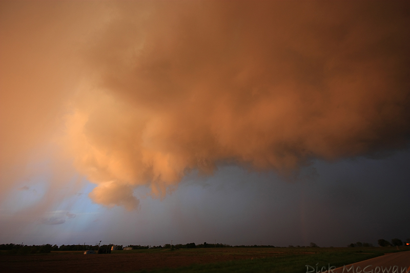
We continued to trail it to the south avoiding the rain which eventually wrapped around it, obscuring our view. Our south road also turned back west away from the storm but thankfully the storm weakened, so we shifted our focus over to photographing the structure. My previous blog entry was the first structure shot I took and below is the second a little later on and slightly west.

5_6_09_06web

Even though the storm weakened a lot within 30 minutes, it continued to display great structure. We continued south and then east to Prescott, Kansas where we would shoot our last photos of the night.

5_6_09_07web

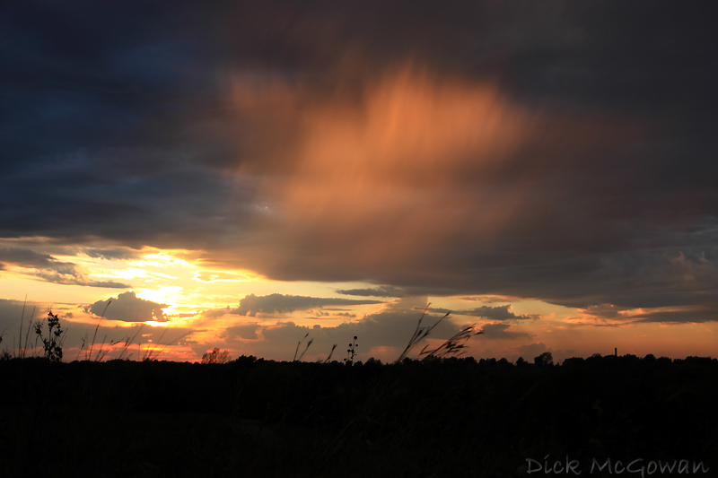
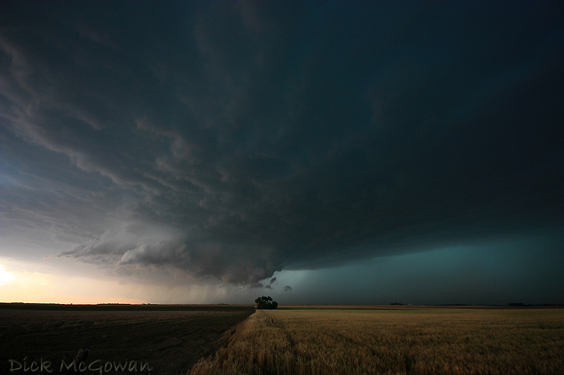
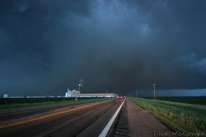
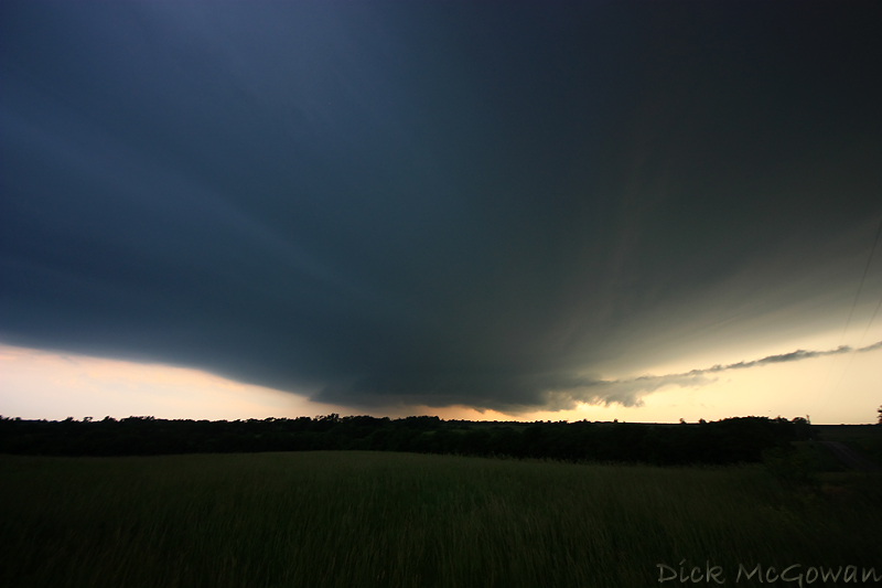
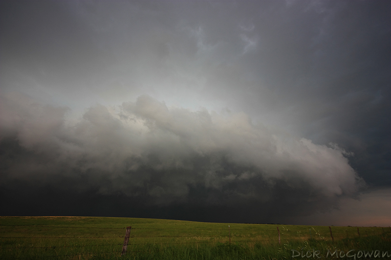
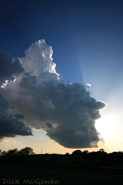
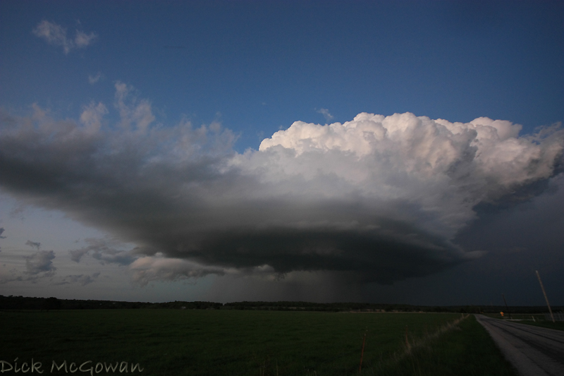
The next day, Thursday, wasn't as cool as the night before. We intercepted a storm near St. Joseph, Missouri that had serious problems sustaining itself and noticed numerous pileus clouds above the updrafts. Below is a photo of where it finally starts to sustain itself near Cameron, Missouri.

5_7_09_02web

Trying to shoot bright white cloud tops with a pitch black base is nearly impossible without either: blowing the whites out on the updrafts, or underexposing the foreground and the base. I had to meter the scene using my XSI's live view and it still didn't help much.

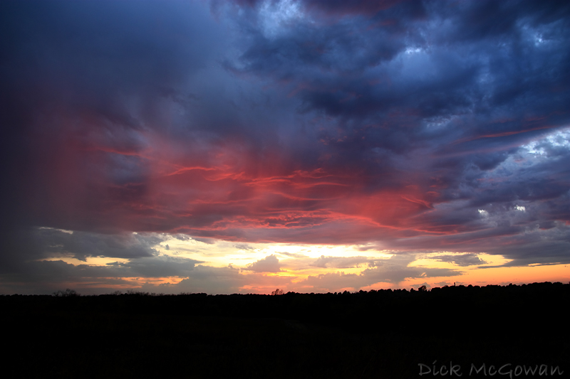
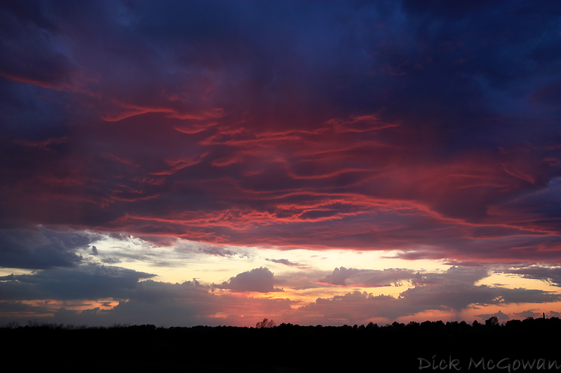
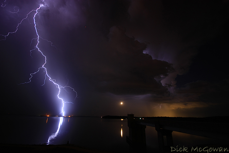
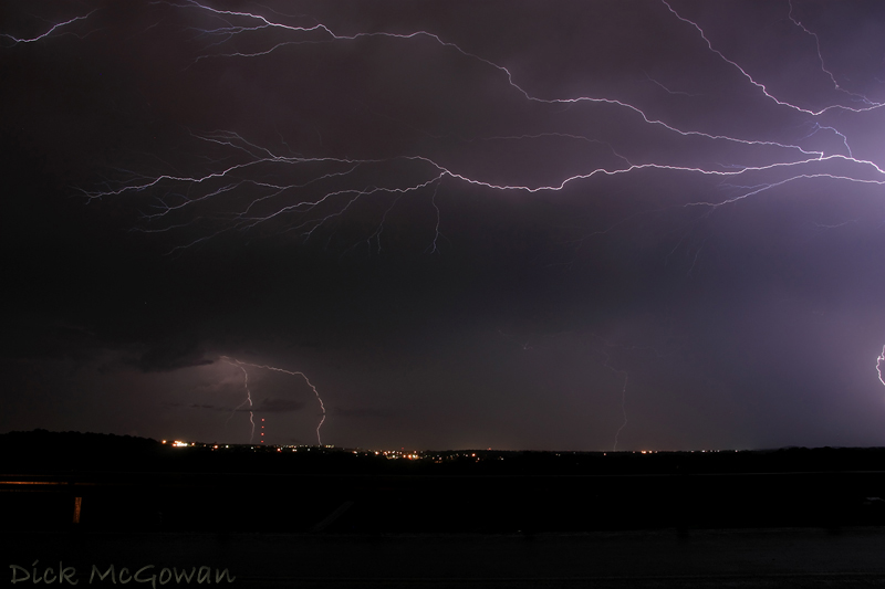
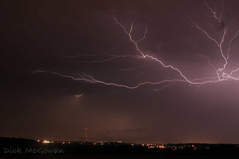
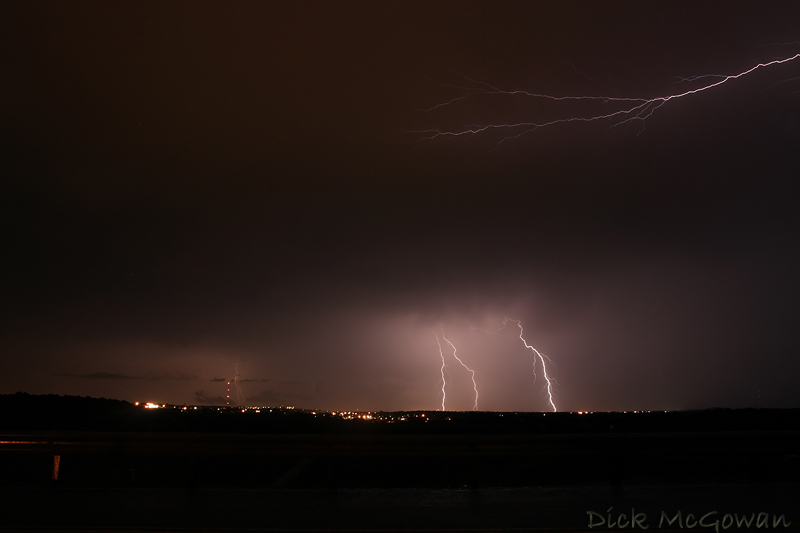
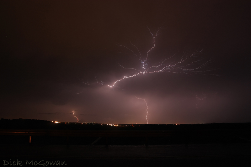
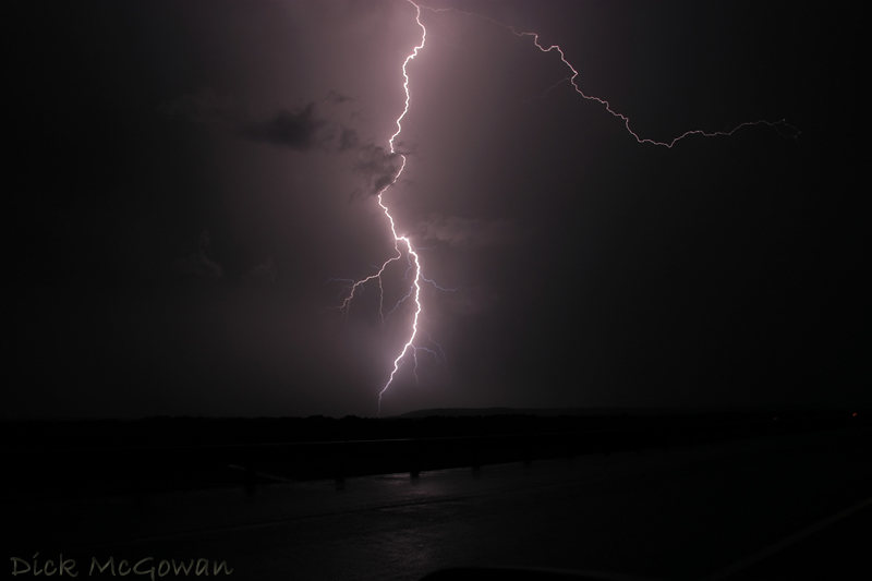
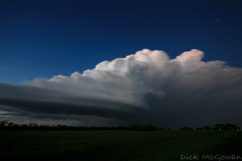
We continued to chase this storm-turned-supercell all the way to Marshall, Missouri till about 11 p.m., trying to get some lightning photos with the low topped structure and an emerging full moon. You can see the rays of the moonlight in the photo below.

5_7_09_01web


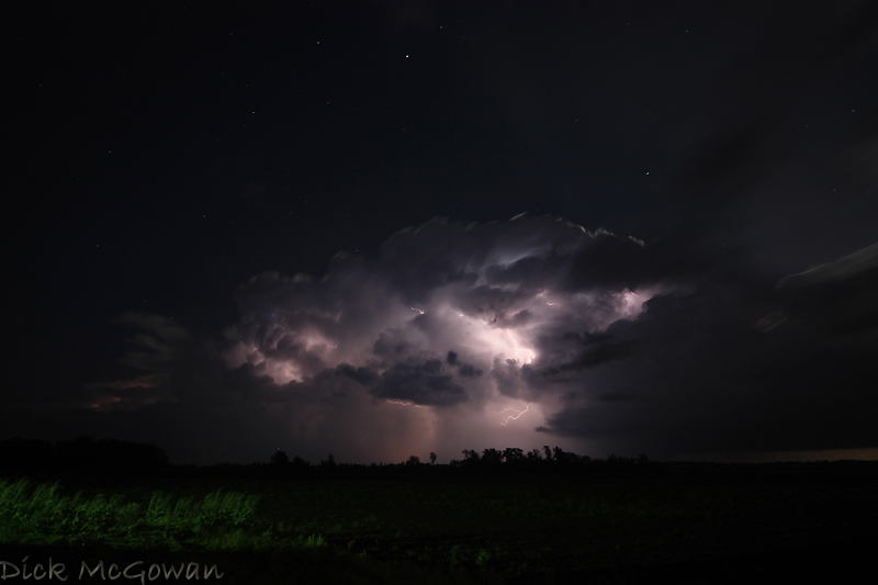
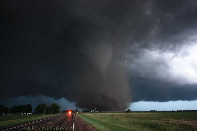
It went on to produce baseball-sized hail as it made its way into the Ozarks.

Not much to look at for chasing prospects in the immediate future thanks to zonal flow in place for nearly a week now, with no signs of life even on the extended models. It could be a slow May!

Contact Me

Contact me @
midwesternmeso AT hotmail (DOT) COM

Blog Archive

wibiya widget