We changed our original target of SE KS/ NC OK to NC Missouri based off of the 18z RUC/satellite where an outflow boundary was present and sfc winds were backed to the southeast from Chillicothe to Kirksville, MO. Given the weak flow aloft further south (where extreme instability was present) and sfc winds SW and parallel to the advancing cold front, it made our 2 p.m. decision an easy one as we left KC.
We probably played around with the storms to the south, where the Kirksville supercell would develop, too long. We lost our data connections north of Brookfield, which didn't matter other than us not being able to see how the storms were developing. We heard the tornado warning issued for the storm to our north, so we took off after it. About 5-10 minutes later there were reports from storm chasers that a tornado was on the ground and we could see something wrapped in rain about 10 miles to our north through the trees, occasionally. We entered the western outskirts of Kirksville as the warning was extended into the city of Kirksville, but never heard tornado sirens in the town for the 7 minutes we were there trying to get west on the highway. That's where the video starts below. As we re-entered Kirksville to catch up, again, there were no sirens going off on the north side of town as another extremely rain-wrapped tornado has already claimed two more lives in North Kirksville.
Here is a google map I've made showing our locations. Andy Fischer has a very detailed analysis of the Kirksville environment here, which I highly recommend reading.
In the video, you can hear me tell Darin to report the tornado several times via SpotterNetwork but we were denied west of Kirksville thanks to no data again. But thankfully, we were able to successfully do it east of Kirksville as our second consecutive poor decision nearly cost us serious injuries from flying debris. Sometimes shit happens, as it does to all chasers. But you'll never see me hypocritically criticize another's decisions or accuse them of trying to get the money shot, because the ones who do, are the envious, competitive and narcissistic ones. We still are very thankful and learned a lot from our poor decisions, which thankfully didn't cost us or anyone else their lives.
A persistent ridging pattern over the Central US for the past 10 days or so has resulted in numerous flame wars within the chaser community concerning chaser behavior, getting close, and opinions regarding the future of the rest of the season. It's amusing to say the least and the same old personalities keep pushing their redundant, hypocritical propaganda and empty prophecies foreseeing the future of storm chasing. I'm glad I'm not in this hobby for the social aspect, because there are numerous socially-dysfunctional nerdy characters (and noobs!) with big egos, who I'm glad I don't have to see in person on a regular basis. The new trend among chasers now is accusing everyone else of being an "SPC chaser" or bashing the SPC...more amusement.
Darin and I have been fishing the past 5 nights in a row, which helps ignore this boring pattern. There might be a few opportunities this next week or so, so we'll likely be out there, but the tornado chances seem small, which is fine by me.
Tuesday, May 26, 2009
Saturday, May 09, 2009
More 5/6 Photos & 5/7 Chase Account
I finally got around to processing a few more photos from Wednesday and Thursday's chases. Wednesday ended up being the better day, but Thursday produced decent LP, low-topped structure (again) and a nonstop lightning barrage for nearly 2 hours.
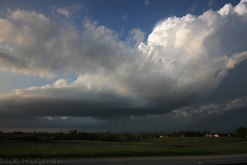
Below is a photo of the western updraft on Wednesday (there's one outside of the photo to the left). It was about 20 minutes after the first tiny reflectivity return that showed up on radar.
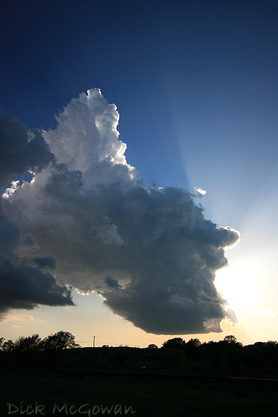
We move south and east from Paola while these two cells begin to finally strengthen! We watch it for a bit then reposition south again while looking back to the northwest at this (below).
At first, it looked kind of elongated, high-based and a little outflow-ish, but we noticed an inflow band forming and feeding in from the southeast. The sun is just enough in the way to make the dynamic range, to shoot photos, a real bitch at this point. About 10 minutes later the base begins to look a little more round (below).
In the photo above you can barely make out that inflow band located at the top right of the photo, which is always a good sign!
We drop south to get out of the precip and about 15 minutes later we pull off on some county road to get a closer look. There are a LOT of trees in Linn County, KS, and the roads/hills are nearly as bad as Missouri, which of course is only 20-30 miles to our east :).
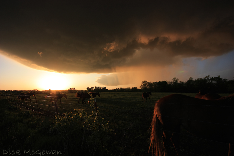
The horses paid no attention to the oncoming storm and were more concerned with us than it. In the photo above, you can see the ghosting (green/red flare) in the picture from having to aim near the sun.
The lighting is pretty much spectacular at this point, displaying a full spectrum of colors. About 10 minutes later, to the right of the image (above), is a huge tree row which we can barely see above, (looking north) but notice what looks like RFD cutting in slowly and a lot of scud being pulled up into the updraft.
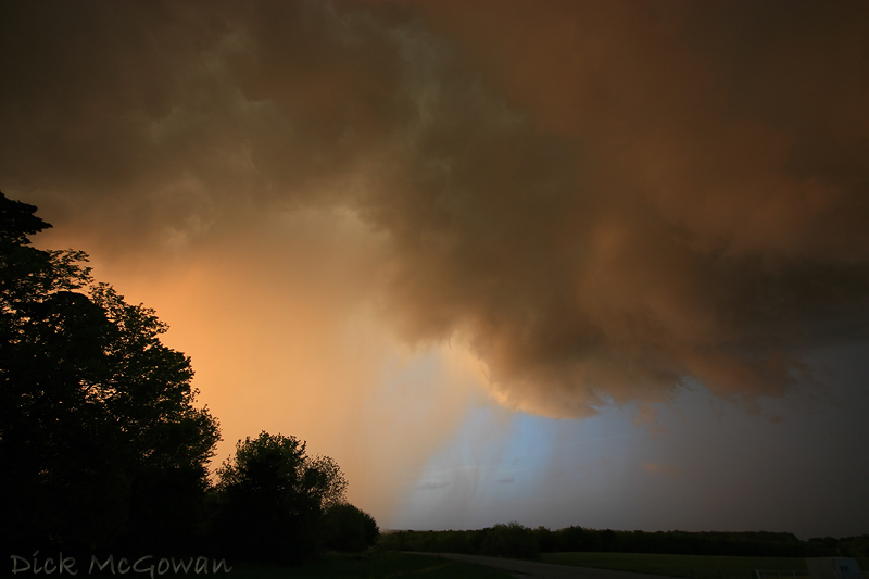
Notice the blue skies behind the updraft/precip core. Behind us, thousands...millions of bright red raindrops are gently falling from the sky, making the scene very surreal. All of these shots, BTW are at 10 mm, so we're a lot closer than it appears.
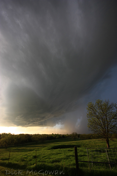
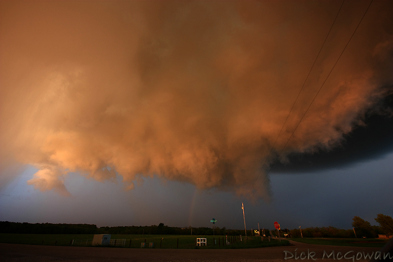
About 3 minutes later, the photo I posted in my previous blog post of the wall cloud is now visible. There's hardly any rotation at this point, just a lot of scud being pulled in rapidly to our east...as we head east. Below, I snapped this photo while driving, a few moments later.
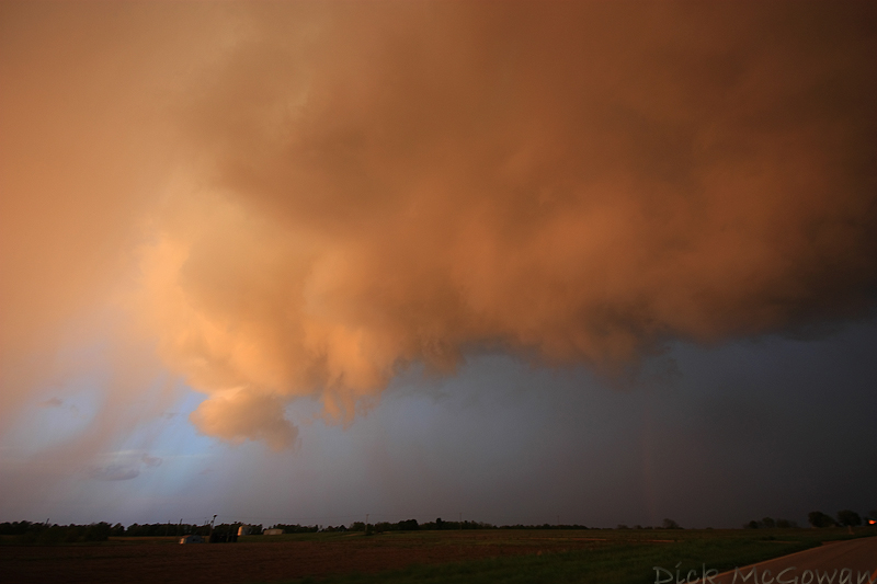
We pretty much drove underneath it (we wouldn't have, had we not felt it was safe to) continuing east as it moves southeast. We're getting into heavy rain east of the developing wall cloud and were surrounded (a full 360 degrees) by a mesmerizing, deep reddish hue of everything...trees, rain, grass, etc. Thanks to that, we lost focus of our road options and missed our south road option. We had just started to turn back around and noticed these, once harmless, rain curtains being forced 180 degrees rapidly back to the west. It was making me nervous because our view of the wall cloud was now obstructed by them. But luckily, we made it south out of the rain and noticed that the wall cloud was now rotating fairly decent and tightened up a couple of times.
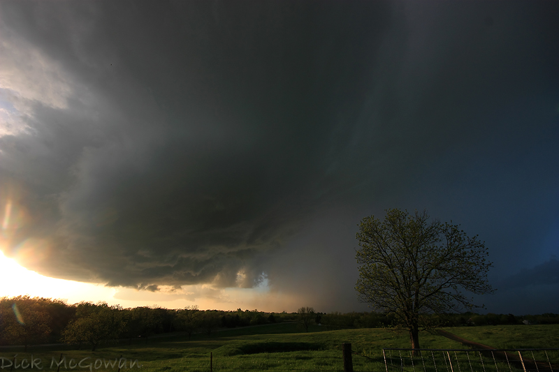
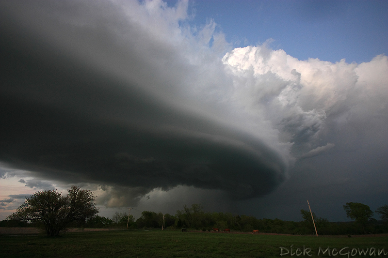
We continued to trail it to the south avoiding the rain which eventually wrapped around it, obscuring our view. Our south road also turned back west away from the storm but thankfully the storm weakened, so we shifted our focus over to photographing the structure. My previous blog entry was the first structure shot I took and below is the second a little later on and slightly west.
Even though the storm weakened a lot within 30 minutes, it continued to display great structure. We continued south and then east to Prescott, Kansas where we would shoot our last photos of the night.
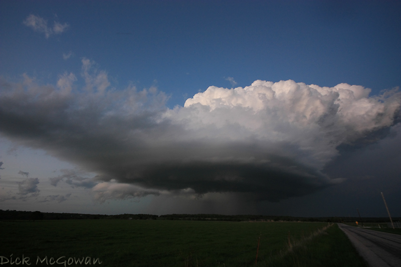
The next day, Thursday, wasn't as cool as the night before. We intercepted a storm near St. Joseph, Missouri that had serious problems sustaining itself and noticed numerous pileus clouds above the updrafts. Below is a photo of where it finally starts to sustain itself near Cameron, Missouri.
Trying to shoot bright white cloud tops with a pitch black base is nearly impossible without either: blowing the whites out on the updrafts, or underexposing the foreground and the base. I had to meter the scene using my XSI's live view and it still didn't help much.
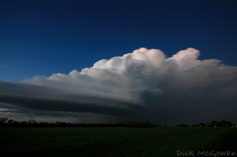
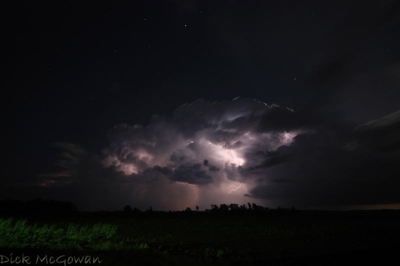
We continued to chase this storm-turned-supercell all the way to Marshall, Missouri till about 11 p.m., trying to get some lightning photos with the low topped structure and an emerging full moon. You can see the rays of the moonlight in the photo below.
It went on to produce baseball-sized hail as it made its way into the Ozarks.
Not much to look at for chasing prospects in the immediate future thanks to zonal flow in place for nearly a week now, with no signs of life even on the extended models. It could be a slow May!
Below is a photo of the western updraft on Wednesday (there's one outside of the photo to the left). It was about 20 minutes after the first tiny reflectivity return that showed up on radar.
We move south and east from Paola while these two cells begin to finally strengthen! We watch it for a bit then reposition south again while looking back to the northwest at this (below).
At first, it looked kind of elongated, high-based and a little outflow-ish, but we noticed an inflow band forming and feeding in from the southeast. The sun is just enough in the way to make the dynamic range, to shoot photos, a real bitch at this point. About 10 minutes later the base begins to look a little more round (below).
In the photo above you can barely make out that inflow band located at the top right of the photo, which is always a good sign!
We drop south to get out of the precip and about 15 minutes later we pull off on some county road to get a closer look. There are a LOT of trees in Linn County, KS, and the roads/hills are nearly as bad as Missouri, which of course is only 20-30 miles to our east :).
The horses paid no attention to the oncoming storm and were more concerned with us than it. In the photo above, you can see the ghosting (green/red flare) in the picture from having to aim near the sun.
The lighting is pretty much spectacular at this point, displaying a full spectrum of colors. About 10 minutes later, to the right of the image (above), is a huge tree row which we can barely see above, (looking north) but notice what looks like RFD cutting in slowly and a lot of scud being pulled up into the updraft.
Notice the blue skies behind the updraft/precip core. Behind us, thousands...millions of bright red raindrops are gently falling from the sky, making the scene very surreal. All of these shots, BTW are at 10 mm, so we're a lot closer than it appears.
About 3 minutes later, the photo I posted in my previous blog post of the wall cloud is now visible. There's hardly any rotation at this point, just a lot of scud being pulled in rapidly to our east...as we head east. Below, I snapped this photo while driving, a few moments later.
We pretty much drove underneath it (we wouldn't have, had we not felt it was safe to) continuing east as it moves southeast. We're getting into heavy rain east of the developing wall cloud and were surrounded (a full 360 degrees) by a mesmerizing, deep reddish hue of everything...trees, rain, grass, etc. Thanks to that, we lost focus of our road options and missed our south road option. We had just started to turn back around and noticed these, once harmless, rain curtains being forced 180 degrees rapidly back to the west. It was making me nervous because our view of the wall cloud was now obstructed by them. But luckily, we made it south out of the rain and noticed that the wall cloud was now rotating fairly decent and tightened up a couple of times.
We continued to trail it to the south avoiding the rain which eventually wrapped around it, obscuring our view. Our south road also turned back west away from the storm but thankfully the storm weakened, so we shifted our focus over to photographing the structure. My previous blog entry was the first structure shot I took and below is the second a little later on and slightly west.
Even though the storm weakened a lot within 30 minutes, it continued to display great structure. We continued south and then east to Prescott, Kansas where we would shoot our last photos of the night.
The next day, Thursday, wasn't as cool as the night before. We intercepted a storm near St. Joseph, Missouri that had serious problems sustaining itself and noticed numerous pileus clouds above the updrafts. Below is a photo of where it finally starts to sustain itself near Cameron, Missouri.
Trying to shoot bright white cloud tops with a pitch black base is nearly impossible without either: blowing the whites out on the updrafts, or underexposing the foreground and the base. I had to meter the scene using my XSI's live view and it still didn't help much.
We continued to chase this storm-turned-supercell all the way to Marshall, Missouri till about 11 p.m., trying to get some lightning photos with the low topped structure and an emerging full moon. You can see the rays of the moonlight in the photo below.
It went on to produce baseball-sized hail as it made its way into the Ozarks.
Not much to look at for chasing prospects in the immediate future thanks to zonal flow in place for nearly a week now, with no signs of life even on the extended models. It could be a slow May!
Thursday, May 07, 2009
Low-Topped Beauty......in May!
About 3 p.m., I noticed a lot (100-150 j/kg) of 0-3km CAPE pooling along a surface trough in Eastern Kansas while an upper level disturbance moved SE from NE/IA. There were relatively cool temps aloft (-14 - 18 at 500 mb) and upper 50 to low 60 dewpoints in place. I emailed Darin at work and he had noticed this too, so we met up around 4:30 in Eudora and watched numerous towers go up and down along this boundary to our immediate west. After most dissipated, more went up to our south, so we moved to near Ottawa, KS and watched much of the same. Luckily, persistence paid off and two storms eventually became one supercell which nearly produced a tornado in Linn county, KS. It didn't matter though because the structure was amazing and the orange hue the wall cloud and rain curtains we saw made everything seem like a dream. Below are just a couple of photos I've processed, I'll add more (as I'm headed to work now) later. Not too confident in today's setup around here today, but we'll chase it regardless.
Monday, May 04, 2009
4/25/2009 Chase Pictures + More Tornado Pictures on 4/26
On Saturday, April 25th, Darin and I intercepted 4 different high-based supercells, 3 of which had some great structure and produced up to tennis ball sized hail. Just east of Elk City, OK near Butler...we experienced a LOT of significant hail and an elevated, smooth cone funnel directly overhead that persisted for about a minute. Unfortunately, dewpoints mixed out during the late afternoon and into the evening (rapidly) and could never really "do it."
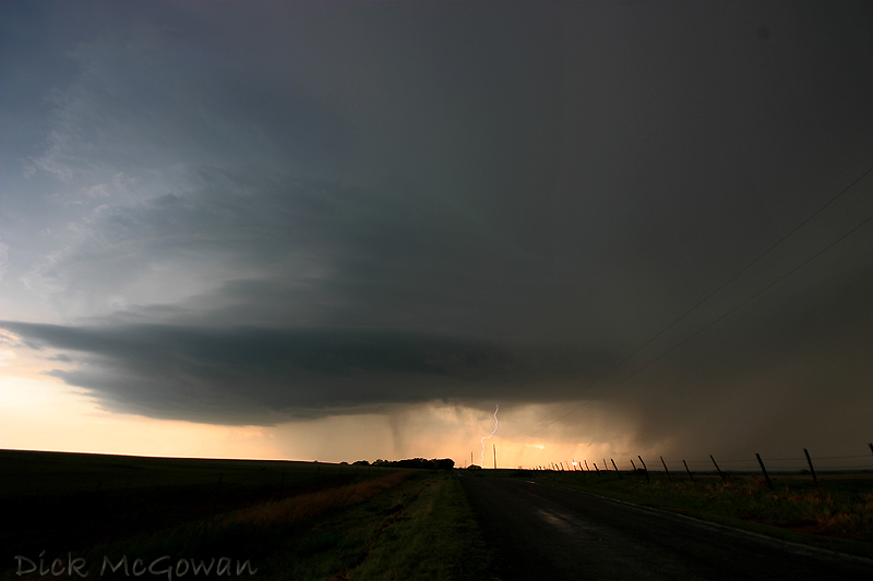
This is the 2nd supercell, below, we intercepted near Clinton, OK which had a nice inflow tail that formed rather quickly. We continued on and noticed a rather quick- moving lowering that formed, but it looked rather cold and disorganized (even though it produced a brief, detached funnel on the southern flank). The storm to its southwest, also, was looking like it may begin to seed it.

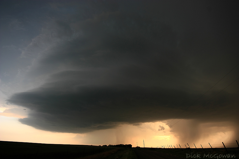
We then ditch this one for the 3rd one, which is below...near Hobart.
And as it gets closer:
And as it's nearly on top of us at dusk (10 mm):
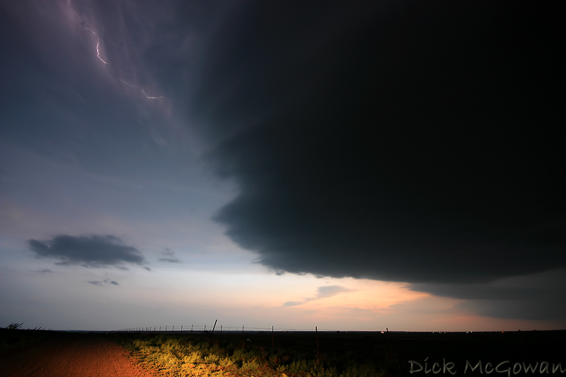
It was pretty tough to get any foreground lit up in the photos, as this was near dusk. The last supercell was just as amazing structure-wise, but unfortunately I didn't have a chance to get any pictures of it (but we encountered a plethora of golfball sized hail)
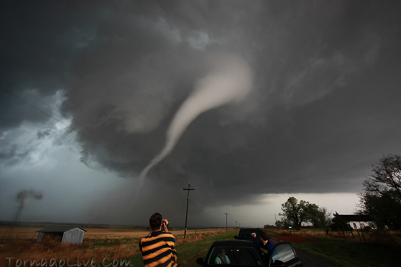
And then another (below) from the 26th, I've still got a LOT of photos to process and only so much time to do so. More soon, hopefully. We're still debating on whether to chase tomorrow and may choose the Western Kansas target, should enough instability develop.
This is the 2nd supercell, below, we intercepted near Clinton, OK which had a nice inflow tail that formed rather quickly. We continued on and noticed a rather quick- moving lowering that formed, but it looked rather cold and disorganized (even though it produced a brief, detached funnel on the southern flank). The storm to its southwest, also, was looking like it may begin to seed it.
We then ditch this one for the 3rd one, which is below...near Hobart.
And as it gets closer:
And as it's nearly on top of us at dusk (10 mm):
It was pretty tough to get any foreground lit up in the photos, as this was near dusk. The last supercell was just as amazing structure-wise, but unfortunately I didn't have a chance to get any pictures of it (but we encountered a plethora of golfball sized hail)
And then another (below) from the 26th, I've still got a LOT of photos to process and only so much time to do so. More soon, hopefully. We're still debating on whether to chase tomorrow and may choose the Western Kansas target, should enough instability develop.
Subscribe to:
Posts (Atom)