Email me at midwesternmeso (AT) hotmail [DOT] com

Please note: All images and videos on this blog are copyrighted by myself and may not be used without written permission. Any persons or entities who do not seek written permission will be held liable for copyright infringement(s) and will be subject to monetary compensation not to exceed $150,000 USD. (In pursuant to 17 USC Section 504(b) and (c), 17 USC Section 505.)

Wednesday, June 24, 2009

June 17th Aurora, Nebraska Tornadoes


The supercell (below) as the new updraft formed and strengthened dramatically right before our eyes just a few miles west of Grand Island. We hung back a little ways at this point to get some structure shots as it wasn't close to producing a tornado.

Quick Note: These photos/videos are copyrighted by myself and any unauthorized use will be prosecuted to the fullest extent of the law, regardless of the party or parties involved.

Grand Island, Nebraska Supercell

Reed Timmer (below) as he looks on, still in shock, from taking a direct hit from the tornado (and can be seen in the video driving by, then tail lights as it forms in front of us). His outer window was broken out (bullet-proof window could not be pulled up in time), spraying glass into his face and others riding in the Dominator (aka SRV - Storm Research Vehicle).

Reed Timmer + Aurora, Nebraska Tornado

Another of the tornado later on:

Aurora, Nebraska Tornado

More later, I've been extremely busy lately. I also intercepted on Saturday two brief tornadoes near Princeton, Kansas and was on the phone with the TOP NWS most of the time, but did manage to snap a lot of photos and video.

Thursday, June 18, 2009

June 15th and June 17th Tornadoes

I have little time to write as I'm getting ready to head to Iowa to see if we can't make it 3 chases in a row with tornadoes...I'll let the video and pictures speak for themselves.

June 15th, 2009 Edwards County, KS - From Kinsley to Macksville, Kansas.


June 17th, 2009 Between Grand Island and Aurora Nebraska. (Darin shot this)


I was actually supposed to chase with Reed Timmer today to get some shots of him in action, but as our 2009 luck would have it, the opportunity presented itself last night. I have so many photos to process in the coming weeks, it isn't funny...insane structure and photos of TVN's SRV getting hit by the tornado (along with video). I don't usually get this excited, but last night was one to remember forever.

Wednesday, June 10, 2009

Fabian Guerra, 6/7/2009 Chase Report

Edit: Tornado pictures today in Nevada County, Missouri (Russel Parsons)

As Darin and I were busting in West Central Iowa this past Saturday, we learned that a fellow chaser, Fabian Guerra passed away on his way to pick up another chaser in Des Moines the night before. According to the police report, a deer jumped out in front of him, causing him to swerve across the median and then proceeded to hit a semi. I knew Fabian as one of the first chasers in the community and met him on a couple of occasions, once in 2005 and the night of the Greensburg tornado in 2007. We also chatted quite a bit in an old storm chaser chatroom about upcoming chases. Dennis Sherrod has set up a memorial fund, which you can donate to here. He will be missed.

On Sunday, Darin, Lexi, Eric and I jumped on a pair of supercells, that failed to produce anything other than extremely large hail from Pawnee City, and the second from Oregon, MO eastward. Here's a video of my car being destroyed by copious amounts of mostly 2" hail with a few baseballs towards the end near Pawnee City. We were trapped in the hail core thanks to some freaked out farmers who were trying to back their horse trailers into a farm nearby. I couldn't get around them for several minutes as we could hear the hail roar and it cost me 2 new cracks and hundreds of dents into my car.


Here are a few shots of the first supercell (Pawnee City, NE), I have yet to process any from the other.

06012009_01web

06012009_02web

06012009_03web

Yesterday was a big bust, with a cold outflow boundary that fooled us into thinking it wasn't cold. The storm we were on displayed supercell structures, a couple of brief, tiny funnels and for the most part, looked cold and outflowish from the getgo.

Thursday, June 04, 2009

Lightning Photos + More Roll/Crawford Oklahoma Tornado Photos

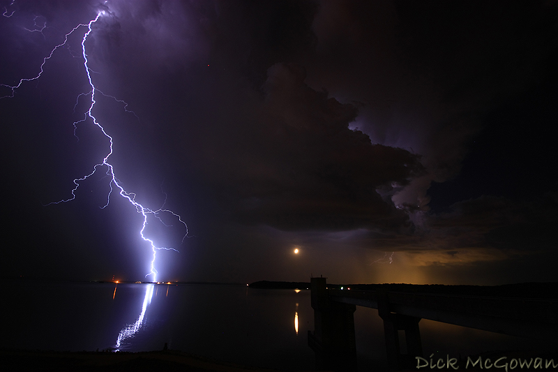
I was half asleep in bed at midnight on the 31st when I saw lightning flashes along the apartment next door. Checked radar and noticed some storms firing along a retreating cold front (?) or a moisture axis (?), or perhaps it was the WAA regime along a stalled front (but was sure it settled much further south of Lawrence) . I briefly checked SPC's mesoanalysis and saw that Lawrence was right on the northern end of 2000 j/kg of MUCAPE and a dewpoint difference of about 10-12 degrees along this boundary.

I zipped to the Clinton dam where Darin, Lexi and I sat in lawn chairs shooting photos for almost an hour and a half. The one and only close CG we saw is below and was shot at 10 mm. The first updraft had some decent structure as you can see (but was better after). If you look closely on the reflection of the water just to the left of the strike, there are 4 fisherman on the shore there. The half moon just happened to be under the updraft base and luckily was rain-free. Shot at my usual, lazy 30 sec exposure, ISO 200 and f/4. Darin, 9 times out of 10, is usually the one who pulls the sweet lightning shots, but my 2009 luck was with me again. There really wasn't much lightning at all for the last 30 minutes we were there as the storms weakened, but of course pulsed back up after we had left.

Clinton Dam Lightning + Moon

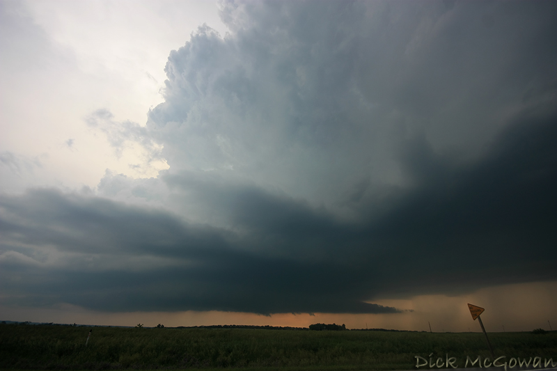
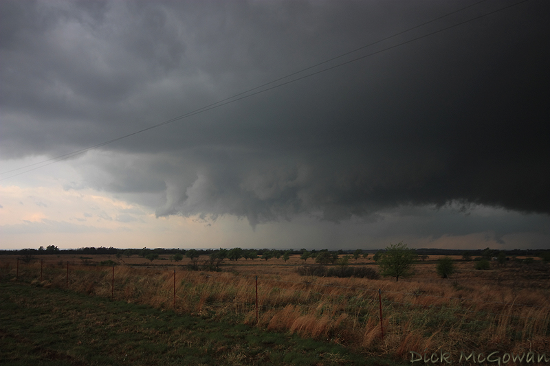
I'm just as lazy at processing photos as I am blog entries, so here are a few more shots from April 26th in Roger Mills county, Oklahoma.

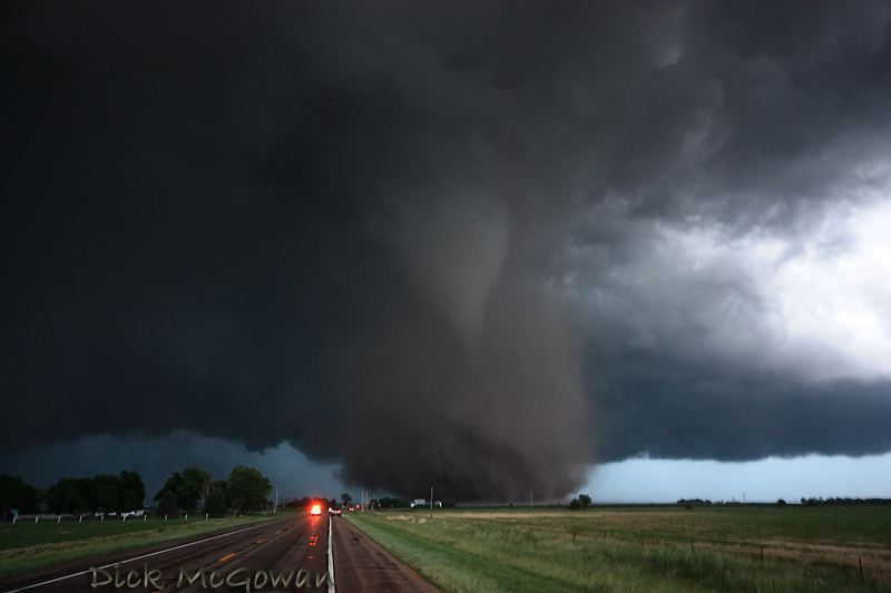
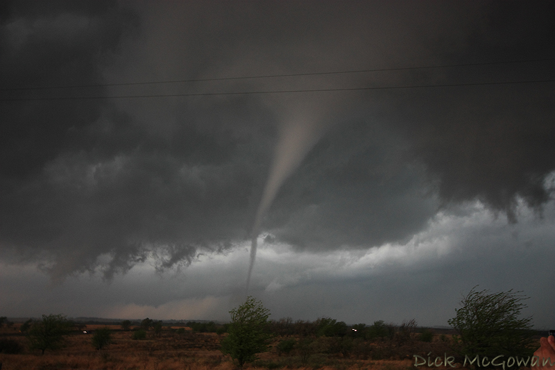
First funnel we could see that lasted only about 20 seconds, no ground circulation was visible from our vantage point. Taken at 20 mm or so. I should just ditch my Sigma 17-70 any more as this UWA is starting quarterback every chase now and there hasn't been much need for the 17-70.

Roll, Oklahoma Funnel

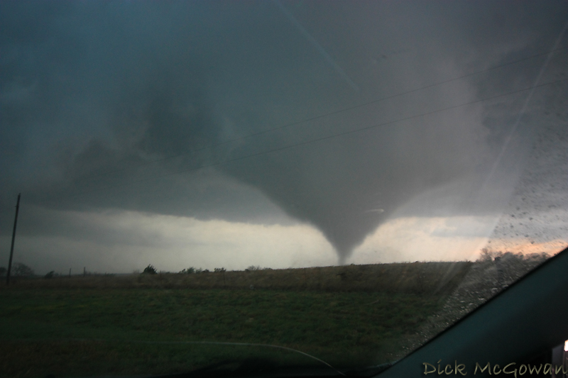
Then about 30 seconds after the first tornado formed:

Roll, Oklahoma Tornado #1

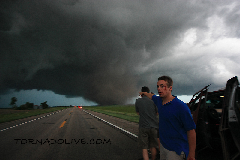
Then a not-so-great shot out of the window for the second (or third depending on who you ask) tornado. I had to bump both cams up to 800 ISO again, which can be a noisemaker. If I had a full frame camera, like many other chasers possess, I could step up the quality to another level. So if anyone reading this would like to purchase me the Canon 5d Mark II, I'd probably let you!

Roll Oklahoma Tornado #2

Now it's time to blow off a little steam by ranting on a Douglas county resident in which I was blessed to have crossed paths with .

Old man in Lawrence last week. I passed a new, silver Mercedes Benz SUV last week casually, on cruise control @ 79 mph about 2 miles east of Lawrence. I noticed he had a bumper sticker on it which read, "Arrogance: When Yes We Can turned into I won." So immediately I think this guy and I probably wouldn't be best friends forever. So I think, is he a successful small business owner who hires illegal aliens for cheap labor yielding huge profits, yet votes against illegal immigration? Or, is he some corporate executive who recently laid off 20 of his employees to make sure he still had enough cash in accounts payable to help continue to feed his addiction for his high-class call girls, or, the pointless, monthly business meetings which are centered at the top tourist attractions across the globe? Who knows.

I've now slowed down to 60 mph as I'm entering east Lawrence off of K-10 and notice Dick Cheney's #1 fan riding immediately behind me and is on my ass, not the 10-15 foot stuff, the 2-3 foot stuff. This makes for braking safely, for the posted 45 mph, nearly impossible now. I gently push my brakes, which instantly throws him into a rage, as he swerves over into the right lane to pass, then subsequently cuts me off purposely to get in front of me. He's now breaking the law at 20 mph over. Road rage is very contagious at this point, so I punch it, showing him the more skilled way, of riding someone's at 65 mph in a 45 (Yep, I'm breaking the law now too).

Five years ago, without hesitation, this guy's new Mercedes SUV would have had a custom-made, size 13 shoe souvenir engraved into the driver's side door. But, I elected to even things differently, watching him panic then trying to lose me for a good mile. He finally ducked into a gas station at the last second and I continued on. So if you're reading this, piss up a rope buddy!

We're off to Colorado tomorrow, not thrilled again for this weekend's setup, but it beats any pattern we've been in, in the last month. Probably be a week or two of cap busts from Mother Nature for her grand finale of a not-so chaser friendly year. When summer rolls around I hope to have more time processing photos.

Contact Me

Contact me @
midwesternmeso AT hotmail (DOT) COM

wibiya widget