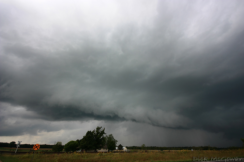
Derek Shaffer and I targeted Iola, Kansas prior to leaving KC, and didn't make it that far south when a storm fired SW of Garnett (below)
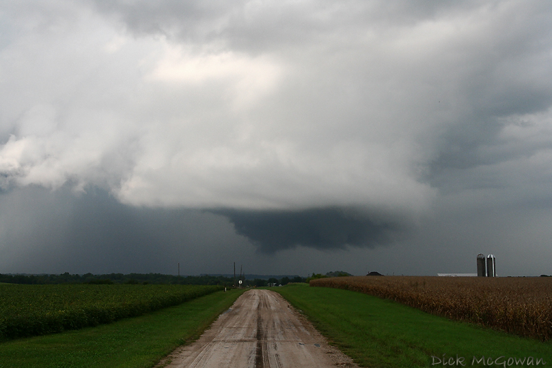
It was fairly high based at first, but quickly lowered itself within 30 minutes and we trailed it almost right up to my front porch. It looked good near Greeley, Kansas (below) on US 169.
And underneath this "chef's hat" meso (yes, I made up that term, but have used it several times lol) spun up a few vortices as it rotated fairly strongly. They were very thin ropes which lasted about 15-20 seconds at the most. The storm wasn't even tornado warned at the time and I guess Spotter Network needs to verify your password even though I was logged in...for me to make a report. I tried resetting the password and it said it was incorrect, so I don't know what's going on with that.
So I then tried dialing 911 as a last resort where it dropped my call at least 5 times. By the time I got service again, the 911 dispatcher left a voicemail and the storm wasn't as impressive despite having a nice BWER on radar. We continued to flank the storm debating whether to ditch our isolated supercell for the one immediately to our north but feared ours would seed it which was just SW of Baldwin City and had impressive rotation. Nah...our supercell and ingest all the low level CAPE...right,?....plus, the storms now trailing ours is congealing into a line...and we would have had to punch north through this one which might have taken time since the storm was moving northeast at 30 mph, and I liked our isolated HP storm.
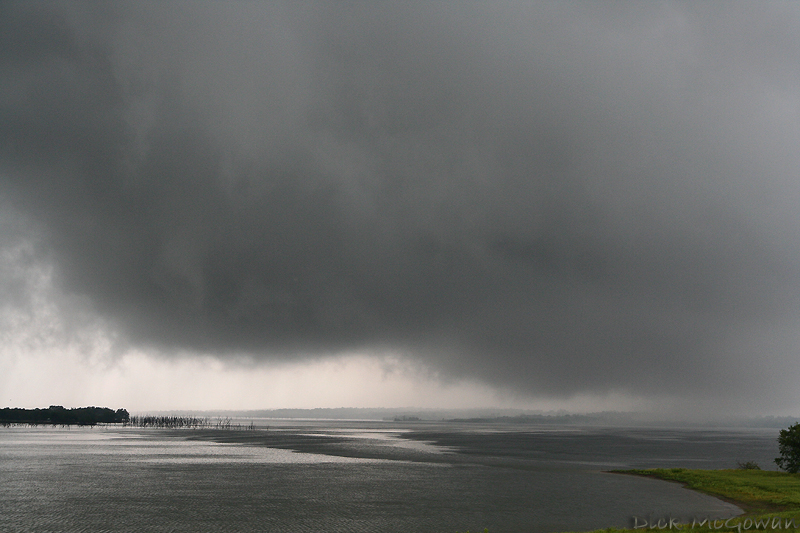
....We continued to follow it to the south side of Hillsdale Lake where we drove underneath the rotation, accidentally, thanks to the road bending, but we managed to position ourselves for a decent view, and were treated to watching a ground-scraping meso that hovered above the lake water.
This photo below...on the horizon...if you put your left hand's thumb on the edge of those trees on the left, (positioned horizontally and to the right) you can see where there were weakly rotating rainbands, which I think was a weak waterspout (tornado over water, whatever!). Lots of turbulence going on ahead of that, but the storm continued to look outflow dominant and "cold." We are looking DOWN here (north) off the damn. Look closely at the cloud base vs. the lake water. I'm guessing 80 feet tops for the LCL's here...it was pulling scud off of trees as it moved past the lake.

We headed east, then flew north on US 169 to Spring Hill with this view (below) to our northeast. This is at 10 mm...the top of the updraft is actually right above us, as I shoot this straight out from my car. The area of interest is just where our paved road bends on the horizon and to the left. Updrafts looked identical to the July 29th supercell I saw, low-topped in nature and the same dark greenish-blue hue to it.
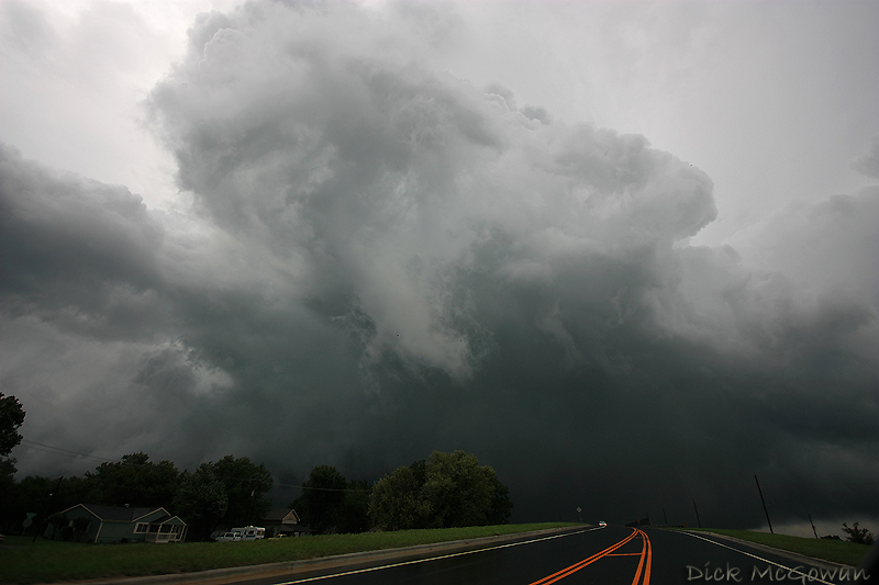
I was never concerned of anything even remotely strong impacting the southwest suburbs (now) of Kansas City. We head east to US 69 to south Overland Park where there are miles upon miles of $400,000 houses (and up!) in the path of this "cold" looking wall cloud heading directly at us at the 151st street exit. (Below)
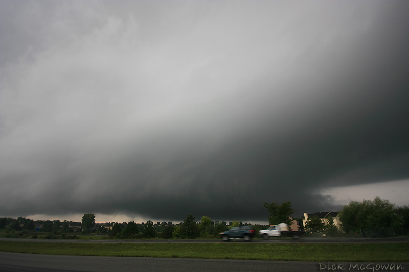
It's really pulling in scud on the right side of the photo (we are looking west) and forms a tail cloud. This sup has a more pronounced vault region to it on the right as well, than it did earlier...but still, a chaser knows this thing isn't going to produce. I clamped the video camera on the window mount and filmed, as heavy traffic is headed south at 5:40'ish nearly bumper to bumper. I wonder if any of these people knew what was going on. Sirens have been blaring and yet Mr. Joe Corporate is gonna get home, by golly, so he can grill him some steaks!
This thing passes directly over us with, at first westerly outflow winds at about 60 mph, bending the trees in front of us, with lots of rotation/strong turbulence on the cloud base that I can jump up and touch...and then a familiar switch back from the east at the same speed and Derek and I yell at the same time, seeing rotating rain bands crossing the highway and hitting my car for about 2 seconds...then it was over. A weak tornadic circulation that didn't even rival some straight-lined winds I've encountered before!
There's no way we could keep up with traffic and KU was playing in an hour, so we headed back to Olathe just in time to get a table at Johnny's with Derek's brother, Kevin and another guy, and watched radar until gametime. Not a bad chase at all! So much for not writing a detailed account!
So weak spinups that won't be counted by me as a tornado...since my views on counting tornadoes has changed. IMO, counting tornadoes is used to boost egos or to appear credible, etc, and with chasers counting tornadoes differently (and often times much HIGHER than actual), is irrelevant to me any more because I don't seek any of the above. It's successful intercept days that I count now vs. # of chases and today ranks as a 1/2/ ~30 this year.
Edit: That storm to our north that we blew off, Darin bagged a huge tornado after he left work (with no data). It produced EF-1 damage near Eudora, Kansas...a kick in the nuts to me since I had hyped this day up and blew it. Congrats to him.
The Okeeffe's were also chasing the same storm we were and have a report up.
Jon Davies is the "man" as always, and did a post analysis case study for those interested in the conditions.
It was a day where you had to either compromise 0-3 km CAPE for the better helicity or vice versa....I didn't know if there was enough heating to begin with, so I chose the instability...our storm was on the southern edge of the good 0-1 km SRH ingesting maybe 100-150 tops, whereas (per spc mesoanalsyis) the "Eudora" tornado was further north, bullseyed in thejavascript:void(0) good stuff at around 250 m2/s2 SRH accompanied by a 40 knot LLJ. I still can't believe there was any instability there, having been there an hour before with cool temps and a socked in sky. Oh well.......

2 comments:
I was the one who reported the tornado north of Spring Hill. We were right under the wall cloud and we came over a hill only to see a weak debris plume that was rotating under strong rotation. I didn't believe it at first, and gave a good look at it then realized I needed to snap a picture and was fumbling for the camera and then we lost it for good behind buildings and trees. Yea I know it sounds made up, but believe me man it was a legit tornado. haha. Nice pics btw.
Oh I believe you, there was a period of about 10 minutes (took a wrong turn lol) where we couldn't see the rotation...figures we missed something cool.
Ours was the same thing, and by the time I grabbed my camera (I was using the restroom and Derek yelled lol) it was gone. Not a bad local chase for September, we were done and home by 6!!!!!!
Post a Comment