Email me at midwesternmeso (AT) hotmail [DOT] com

Please note: All images and videos on this blog are copyrighted by myself and may not be used without written permission. Any persons or entities who do not seek written permission will be held liable for copyright infringement(s) and will be subject to monetary compensation not to exceed $150,000 USD. (In pursuant to 17 USC Section 504(b) and (c), 17 USC Section 505.)

Tuesday, April 29, 2008

Lots of Stuff: Chase Reports, New Videos, Greensburg Tornado Anniversary

Last Wednesday, I went out and chased a non-severe storm which had a somewhat photogenic shelf cloud with it...not much to say other than I burned $5.00 in gas and was gone about 90 minutes. Near Ottawa and Wellington, KS:


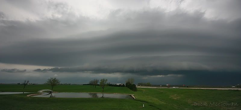
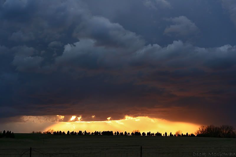
Darin, his mother (who has wanted to go for awhile now) Jordan, Doug M., and I busted till sundown in the southern target on Thursday. We headed north for the lone supercell that was near Hoxie, KS and intercepted it about 5 miles south of Stockton, KS around 10:30 p.m. About 10 miles further to the south, we observed incredible structure, with similarities between it and the June 2, 2005 Limon, CO supercell. The beaver tail on it stretched for miles feeding into a ghostly, beefy updraft with beautiful striations extending upward. We were trying to find a place to park and low-level stratus closed in and we didn't want to move back south in case the storm produced.

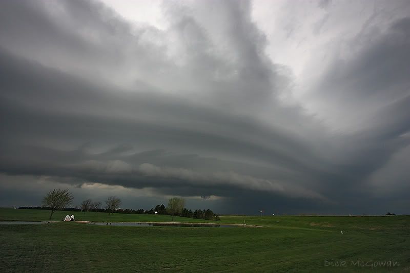
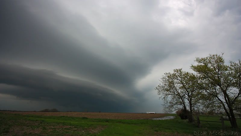
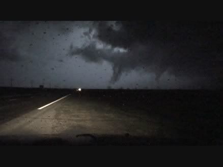
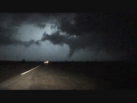
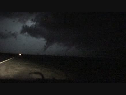
I was on the phone with Reed Timmer, and he jokingly suggested that we sample the softballs being reported in Stockton, which I was half-tempted to do (I love gigantic hail!). Instead, we maneuvered around the 20-vehicle entourage including the DOW's to position ourselves to measure the outflow on the approaching laminar, outflow-ish looking shelf cloud approaching from the west/southwest. NWS in Hastings dropped the tornado warning and our radar stopped updating on the slow connection we were on. It finally updated as we connected to spotter network and we happened to notice a small area of rotation that would reach us in the next few minutes. I quickly flipped around to get south as strong outflow was beginning to hit us. We maneuvered around a few vehicles with the DOW and noticed several pods staked in the ground spaced a few hundred yards apart as I started to pull off the next dirt road. Doug, in the vehicle behind us kept yelling and at first couldn't understand what he was saying, but quickly realized he was yelling, "FUNNEL!!" I look up and to our immediate west and there is, what seems to be, a weak, rotating funnel cloud. I quickly mash it to the next dirt road and film this.

/>

We could visually see the rotation on it, but the funnel on the western edge of this "feature" didn't seem to be attached to the base...but closer observation showed the updraft tilted at nearly 45 degrees, which still leaves me guessing what it was.

On the Discovery channel's blog, they write this:

Of course, the ultimate question is, did a tornado cross the road? Josh, who focused on the radar scans, hampered by a somewhat dysfunctional antenna, says the peak rotations don't indicate a tornado. Justin and Danny think they spotted a tornadic funnel in a flash of lightning. I caught my breath when I saw a sky-to-earth cloud that looked temptingly like a tornado roping out. But I'm just a beginner. A spotter reported a tornado at our exact location with a time that correlates with our deployment. And that same storm went on to damage a house further to the east that night. So the verdict is still out. Justin hopes the pod data will give some credence to those of us who think we intercepted a tornado.


Here are a few video captures (click to enlarge):


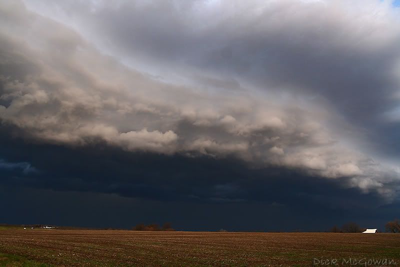
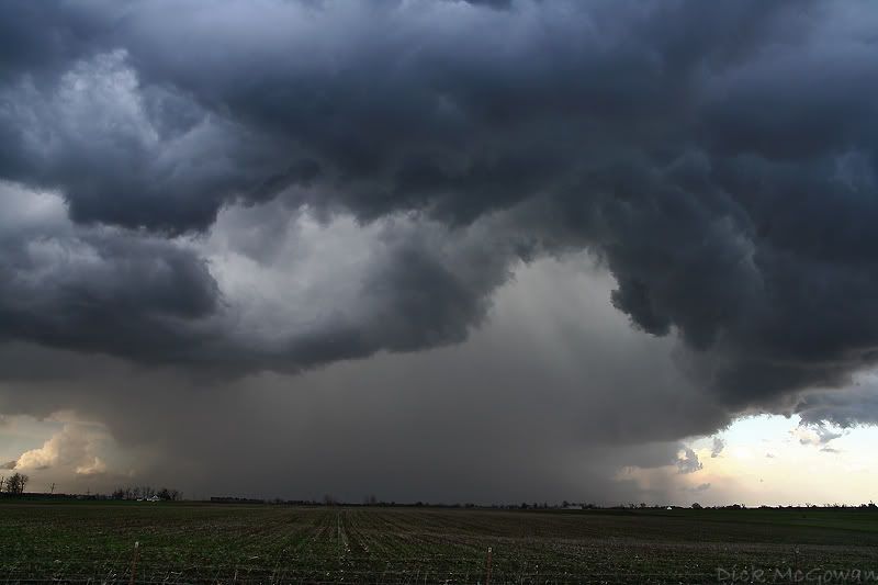
Shortly after, a "storm chaser" reported weak, brief tornadoes right where we were. Either way, it was fun to watch as we repositioned to the east after this and took several structure pictures (which I'll add soon) of a gigantic flanking line, similar to what Mike Peregrine saw on 4/15/06 in NW MO. We let it go (due to bad roads) and probably should have kept going as it produced an EF-2 north of Beloit, KS. We were about 15 miles behind it when it was on its 15 mile journey to the northeast. From what we could tell, there was no tornado warning on it, and were commenting on how the couplet was incredible and were wondering why there wasn't. Our radar was in and out, so there might have been.

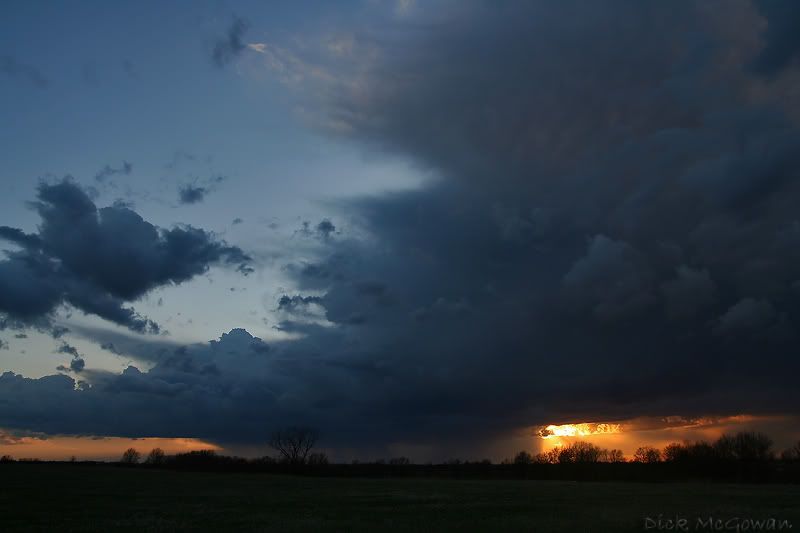
We got about 10 minutes of a glimpse of a "merry-go-round" wall cloud which was responsible for the tornado, and some attempts at tornadogenesis with a few cone funnels, but the rotation would wrap back in rain, and we could never get ahead of the storm to get a good view.

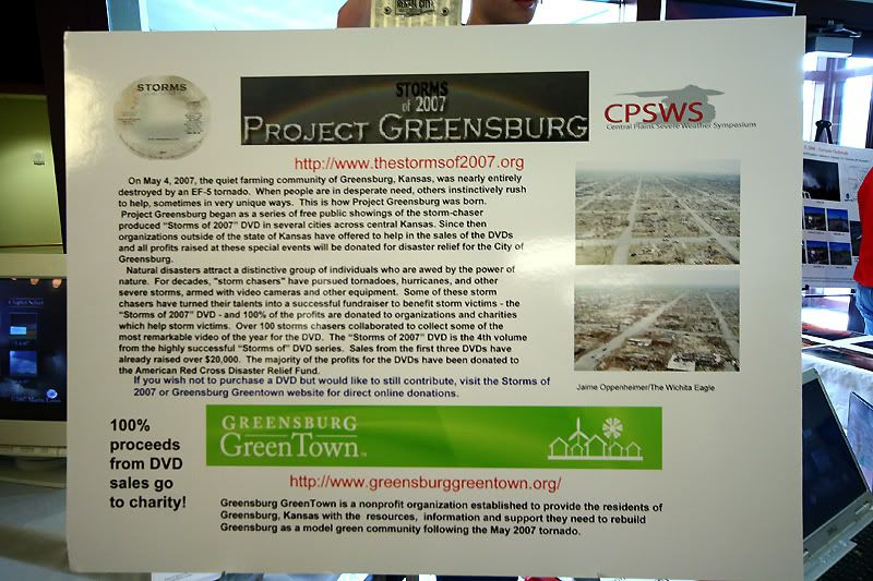
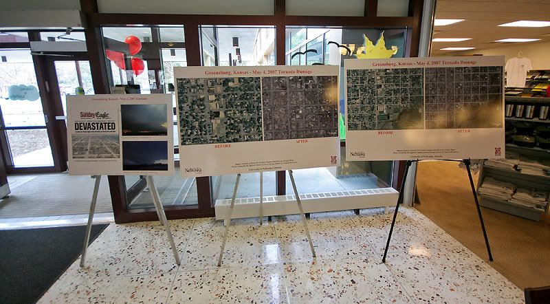
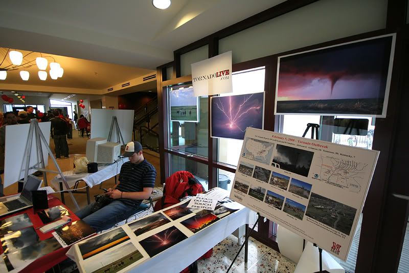
This weekend, we'll be making the trip back to Greensburg for the festivities as well as selling more Storms of 2007 DVD's in hopes of raising money for Greensurg Greentown.

It doesn't look like a chase day for anyone, so those relatively close to the area should show up. CBS's, "The Early Show" has been broadcasting there since Monday and will till Friday. Reed was just on there about 2 hours ago and did an interview for them. Hats off to CBS for not "forgetting" and to create international awareness of the green initiative that will be part of this world's future.

PBS documentary will air this Sunday as well, but only in Kansas. We will probably attend the premiere at 5 p.m. that day in Wichita.

I've been working on our Greensburg video, which Reed has posted on the Storm Chaser show's blog, and two more should be up soon.

Edit: I forgot, StormTube.Org is up, no legalities, better quality, non-compressed and bigger players are offered to storm chasers. What a great site!

Monday, April 21, 2008

Severe Weather Today

Chase Target (triangle): 1st target: Iola, KS east to Nevada, MO then back to the SW to Girard, KS. 2nd Target: Hobart, OK to Anadarko, OK

CINH should erode by 21-22z along the KS/MO state line with the NE/SW oriented cold front approaching the northern target, while the dryline mixes eastward near the surface low into SW OK. 0-3km MLCAPE, surface-based instability, as well as the best convergence, will all be maximized in SE KS/SW MO as well as SW OK near the triple point, around this time frame. While not as strong as one would hope for, 0-6 km shear, today, is sufficient enough for supercells/and or supercell structures in KS/MO, and is also adequate enough for the same in SW OK.

KS/MO should see storms fire by at least 22z - 23z, (5-6 p.m.) but the SW OK target might hold off until near dusk. I don't think there is much of a tornado threat early on (as storms may be elevated and not surface-based, along with weakly-backed surface winds), but as the low-level jet strengthens at dusk, boundary layer moisture should be adequate enough, as SBCINH further erodes...in which there may be a brief window for a couple of tornadoes in each of the two areas. There is a pretty tight moisture gradient in the Oklahoma target on the triple point at 0z...and better shear, but convective inhibition seems stronger there, and may suppress convective development all together.

However, the 4.0 km NMM WRF shows no precipitation breaking out for Kansas and Missouri, while the SW Oklahoma target does, between 23z and 0z...we'll see. Someone should keep tabs on this thing on every setup and compare it with reality later on, and see what it does good on, and what it doesn't. I'm sure someone does, just no one that I know lol.

Although weak, there still is pretty good directional shear today, compared to the more speed-shear, uni-directional setups that have barred any major outbreaks on the Plains so far this Spring. I'd settle for a slow-moving sculptured supercell, with some baseballs hitting my car, and consider it a victory. But it really all depends on the timing/arrival of the mid-level support tomorrow to help erode the cap, bringing cooler temps aloft and stronger vertical forcing.

If a supercell does form ahead of the cold front during the late afternoon/evening, and moves east/south-eastward and the cooler air doesn't undercut it, one could probably survive a few hours with the amount of instability in place. (I remember one doing that LAST YEAR at this time producing a few tornadoes in this target area, and my colleagues and I blowing the day off.)

Today could be the "sleeper." SPC has a 5 percent torn/15 hatched hail out on the 6z outlook, outlined with a slight risk. I'm going to wish I was out there today, as will others who sat it out. It always works out that way.

I, unfortunately, will be giving a presentation on GIS during all of this, and can not chase. I blocked all of my classes on Monday, thinking it would leave me the rest of the week to free-up for chasing, and you know what day always seems to be the day to "chase." Tragic, I know. Oh well, not much to speak of yet, and school's almost out, so we'll see how May shapes up to be for us goofy, cloud chasers.

Good luck to anyone chasing today (especially Chris White from Virginia who planned his chase trip awhile back and has only 2 more days).

Saturday, April 19, 2008

Spring...is here


Tornado! Up from the Debris book


After getting several requests for the book (Including People Magazine) and numerous google searches, I followed up with Daniel, Eric and Fern on how people can purchase this book. Feel free to use any of this information or the picture for the book on your websites/blogs.

From the book:

An EF-5 tornado plundered through the farming community of Greensburg, Kansas on May 4th, 2007; stripping it bare of homes, businesses, huge trees, and entire farmsteads. In its wake, only a pile of debris was left as evidence of what was once a peaceful existence. Miraculously, only twelve people lost their lives.

As they pulled themselves up from the debris, it was with great thankfulness from God who spared their lives. This book is the account of what happened that day, and in the days following. It is their 'thank-you' to all those 'ministering angels' who helped them in so many ways to dig out of the debris.


They are around $8.00 and all of the profits go to the Christian Disaster Relief...which is really cheap and will help a lot of Mennonite families that were affected by the tornado. Several storm chasers and meteorologists contributed to this book with their images and accounts (including fellow KC area storm chaser/meteorologist Andy Fischer, whose photo is on the cover).

157 pages, paperback.
Eric and Fern Unruh
Mennonite Press Inc.

To purchase one please email:
gospelpublishers(At)cogicm(DOT)org

Canon's New Rebel XSi...should you upgrade?


Well, it depends. If you own the Canon Rebel XTi, I'd say no, you're probably not going to be gaining much paying a few hundred to upgrade. But if you own maybe an old Rebel or Rebel XT, I'd say definitely "yes." I just upgraded and am very impressed not only with the body itself, but with Canon's software that came with it.

Their new "raw image processor" software is a MAJOR improvement. I didn't use other RAW image processing programs other than theirs on the old XT, and was hoping this new software was basically the same. It is, but it has more features and also allows you to edit in 14 bit in RAW. I'm not sure what the XTi has, but this has new "settings" in RAW similar to those in JPEG, that allow you to choose which to use in RAW...such as landscape, standard, portrait, monochrome, faithful, and neutral. I'm gonna have to learn more of what this is all about in the coming weeks, but "faithful" setting seems more appealing for storm chasers, focusing more on highlights and not blowing out whites in the sky/sun areas.

I can't get over the fact of how my images look "sharper" in RAW, which now, along with the other settings such as contrast, saturation, color tone, all have more in-depth settings. The above image was done with very little post-processing...in fact hardly any at all. It's just a "test" shot I did the other night on my way to Lawrence.

Some new features I didn't/don't have with the XT: highlight tone priority. One thing I don't understand is why you have to have a minimum of ISO 200 with it, instead of just one. Something that doesn't bother me too much. Spot-metering...one thing I know little about is metering (or exposing an image well) and plan on it soon.

Two things worth the money alone, without the above mentioned. Live view. Yep, no longer are the point and shoots the only ones with this function, it's now on here, and gives you a "preview" of how your image will be shot. Want to see what your image will look like at f/8 and exp. compensated -2.3 using spot metering? Your huge 3.0 inch LCD screen shows you before you shoot it. LCD screen and live view make this worth every penny. It's literally 4 LCD screens of my XT stacked across and then down. I can't tell you how many times on my XT I've thought a picture was in focus, but was off a hair due to the tiny LCD screen (and zoomed in).

Grids. You can now view grids on your live view to keep things "level."

More AF points. Makes things quicker now...it's in sort of an oval shape now and seems quicker.

More f/ps. I can now fire off I think 3.5 f/ps...it's QUICK and almost annoying if you have it set on this by accident.

SD card and battery. The new battery took me 1.5 hours to charge the first time, and is still full after me using the live function constantly. I just can't find anyone who sells any "backups." And the SD card people are bitching about is laughable, it's a card okay? If you don't like the "flimsiness" of them, ask yourself why that matters in the first place, then 1. take brick and 2. smash face. They're cheaper (I bought a 4 gb extreme II sandisk for 30 bucks shipped on ebay...not a fake!) and they're smaller. Sometimes I think people bitch about things to make themselves seem more knowledgeable about pointless shit that no one cares about. The same guy who will tell you on a photography forum, that a technique in photoshop is more "clean" another way is also full of shit. Living in Garden City, KS for a long time, I've smelled a lot of bullshit. They both work the same, and look the same, so piss up a rope.

I already find myself reaching for buttons/functions that aren't there out of habit, and that will take some getting used to. But overall, I'm very impressed with this camera (the short time I've had it and even shorter time I've messed around with it).

I was lucky enough to get mine early (thanks Ritz!) and didn't have to wait on BHphoto to "tell" me when they had some in stock. I don't think they (BH) are the cheapest place on the net any more, and I'm sure with their latest "holiday" they've given themselves, have lost out on a lot of sales with the new XSi.

Overall, with the software and body I'd give it a 9.0 out of 10. More later, including images taken with the XT vs. the XSi in terms of noise and quality.

Maybe I'll get to use this new camera on a supercell...something I haven't seen since May of last year, a true supercell, (uncle Chuck has the definition around on the web somewhere) or even one of those tubular things that used to exist, but are so rare this year.

Sunday, April 13, 2008

Thursday's Storm Chase, Streaming Live Video, Canon EOS Digital Rebel XSi


On Thursday, we chased some crappy storms that would disintegrate into nothing when it seemed as though they were moving into more stable air...but then they would almost instantly pulsate right back up just a few scans later. We should have turned around when we were watching storms fire in the dreaded SW surface flow...and the mushy, elongated towers that would go up. I guess the surface low occluded too fast? or dry air surged too far in, like on 2/24/07? We weren't monitoring anything other than surface obs and occasionally seeing if any 0-3 km CAPE was present, which is really all you need for cold-core chasing (or busting) anyways. This is the type of high-based, Outflow-dominant garbage we saw yesterday...I took this one while driving that's why it's blurred on the bottom left.


The live feed went well, with pretty much a solid connection throughout, we just need to get a minidv camera instead of our 20 dollar webcam lol. It wasn't handling the high dynamic ranges well, with blown out skies on occasion, and plus you can't zoom in. Reed and his crew are working hard right now on some excellent additions to the beta version, which is up right now. Darin is also writing some code which will add some neat stuff onto it too. It's pretty nuts to think just a few years ago, the satellite feed which displayed the program, Threatnet (or Wxworx, Baron's,) was like having gold, and now it seems everyone is selling them, since data coverage has become faster, affordable and more reliable.

While SevereStudios has a great concept going with their live video, there is an easier (and free!) way of doing so. Even though I don't agree with some of the stuff they do or say, I am still glad they helped create something very useful which could help coordinate warnings more accurately for NWS offices, media outlets, etc this spring.

So if you are wanting to stream video, can't afford Severe Studios' monthly fees, but wanted to embed the media player onto your site without touching your bandwidth and is entirely free....Simply go to StreamWebtown.com and sign up for the free account...then follow the tutorial. That's what I did back in January and it was simple enough to set up. You can then go here for the code to embed it onto your blog/website. One of SS's "reasons" they said chasers should stream with them, was because with places like StreamWebtown, chasers forfeit the rights to their "streams" since these places provide a free service. While that may be true, I'm not so sure anyone would or ever could do anything with the low-quality stream that is being put out now. Heck, you can have mine, just send me a copy! Maybe in a few years when chasers are streaming in HD, but nothing to worry about now.

Also, a good tip for windows media encoder 9, (which I'm glad we do not have to use any longer!) ...is to run the stream per kb a little under the speed you anticipate getting. If you're pulling 135K, then select the 144K option. So... if you're on the option for multiple bitrate for a T1 yet only have a 144k connection, it will constantly disconnect and throw out errors. I had several problems staying connected with the Windows media 9 version no matter what I did to it, but this new encoder we have is so simple, you just plug in the camera and hit broadcast. It stays connected unless of course our data drops its connection. No dropped frames, or weird errors, once I configured it correctly, it hasn't given us any problems.

I pre-ordered the Canon EOS Digital Rebel XSi a month or so ago, and it arrived 2 weeks earlier than expected! All I have to say is WOW! It's a big upgrade from the XT, which I've had for almost 3 years now. The LCD screen is literally 4 of my XT's screens placed side by side. I'm just now playing around with it, but will post about it I'm sure in the near future.

Some pictures from Thursday's chase:


Thursday, April 10, 2008

Chasing Today

We should be streaming here on TornadoVideos.net as "Stream 2" later today as well as our website, TornadoLive.com. We've teamed up with Reed, Joel and others to stream video this Spring. Steve Miller TX and Jay McCoy caught a nice hose on their live video feed (which I must have missed by seconds) the other day in Texas. This seems to be the big thing this year. Last year, Darin and I ran a live webcam, not video, and displayed at least 3 tornadoes on there from 3 separate days. I'm digging everyone doing it this year, since I can't chase all the time, it allows myself to follow the action by watching that, and spotternetwork...great stuff.

Jordan, Darin and I should be heading out within the next couple of hours, likely in extreme NE KS, to play the textbook cold-core low. If a dry slot forms, there should be a few tornadoes associated with low-topped supercells near the triple point (or quadruple). This setup is nearly identical to 11/27/05, just placed a little further northeast (warm sector is a little more primed as well). Reed and Joel (who were within 100 yards of a strong tornado yesterday) will be chasing in NE Arkansas and streaming there. I'm not sure where the other guys will be or if they are chasing.

Time to get things ready, and test out everything to see if it works. Good luck to anyone chasing today.

Saturday, April 05, 2008

May 22nd 2007, "Hill City" Supercell

KU will get revenge on Roy "I don't give a shit about North Carolina" Williams tonight. It's payback bitch!

Friday, April 04, 2008

Getting Ready For Spring

Darin and I have been trying to get stuff done before things start getting active...which is real soon. I have a new car (not really new) that I will be driving soon, and we will start drilling into that next weekend. We're also teaming up with a couple of chasers to stream live video on their website...more on that when it gets worked out.

And I think we've worked out a deal with a producer, who's making a documentary on storm chasing, to ride along with us for a good part of this Spring/Summer. I'm sure he'll enjoy our company, we always have a great time! ;-).

The pressure is on...school...getting equipment ready for the chase season...updating our website...weddings...Project Greensburg...I won't be getting much sleep till at least May 12th, when school is out.

Here's a new video of 9/15/06 in South Central Nebraska...close but no cigar, still had great structure and a wall cloud that never could. I'm uploading another one as we speak of May 22nd 2007, Part I and will post it on here when it's done uploading.


PS: If anyone knows why the video is compressing small like that...please let me know, I can't figure out why Pinnacle is doing that on some, and some it's not.

Wednesday, April 02, 2008

Central Plains Severe Weather Symposium

Darin and I were generously invited by Jeremy Bower and Dr. Ken Dewey to the CPSWS in Lincoln on Saturday in hopes to try and sell the Storms of 2007 charity DVD's, which will be benefiting the NPO "Greensburg Greentown." Considering we didn't have any DVD's, we sure took a lot of orders for them and raised some more money to give to those folks. It gives me a great feeling, knowing that storm chasers have helped contribute to the funding in which future communities around the world will be constructed. Daniel Wallach, the director, is a heck of a nice guy and seems like he is pretty passionate about it. I'm sure each and every contributor on the SO 2007 DVD is excited in helping a local organization out...someone who needs the money--an organization made up of almost entirely Greensburg residents.

It was great meeting Mr. Bower and Dr. Dewey, and for their generosities they gave us both. It was good seeing Chris Novy, Ben Prusia and Mike Umscheid again, it seems like we see Mike every week now. I also finally met Dustin Wilcox and Jason McKitrick who were there. It was also great seeing Jon Davies and Shawna Helt who were there as well. Jon was feeling under the weather and he and Shawna took off in the afternoon. Mr. Davies is by far one of the nicest guys anyone will ever meet...Shawna, a very down-to-earth person as well. It's pretty cool, knowing you can sit next to a guy who is one of the top in his field, has been chasing for years on end, has a goldmine full of knowledge, and will just talk to you like you're his friend from grade school...unlike a guy from Boulder we all know, who missed the big one last year!! I guess that's just the way that some people are and will always be.

Here are a few pics of the event. I've never seen so many people who had an interest in weather, gathered in the same place at once! I think there were somewhere around 4,000 people this year. Jeremy and Ken made some amazing displays for not only Greensburg, but for the February 7th 2008 Atkins, AR tornado, as well as other events.


Brian Schodorf's documentary film about the Greensburg tornado should be airing on May 4th on PBS in Kansas and possibly Oklahoma. I believe he's still negotiating with other networks, but the first airing of it will be on the anniversary. Here is a link to his website, with a new trailer on there. In the first one there, that is Brian's uncle Bill Kurtis narrating towards the end. If you don't know who Bill Kurtis is, google him.

Darin and I will be representing the yahoo chasers in the documentary (lol). We were interviewed for it last July and some of our video will be in it as well. Anybody who knows me, knows I avoid cameras like the plague, but I guess this was the one and only exception. You can bet I'll look and sound like a fucking dumb ass, but I don't care.

Lastly, the video link posted in my previous entry has been taken down! I was talking to a producer with Ecotown on Monday night and mentioned I saw it on youtube, and it was gone today! I'm not sure where else you can preview it at, or where the person that had it in the first place even got it, but it's gone.

She also told me the new air date is either late May or early June, bumped up a couple of months from the "Fall" they had originally planned. You heard it first here on the Stacked Plates blog!!!

Thursday looks really good, but I'm low on cash, have school, and won't ever chase further south than Blackwell OK until the yahoos are dealt with down there. I get pissed off enough at the circus up here in Kansas, I'd likely lose it on someone down there and get into trouble! I just don't have that "urge" to drop everything and chase every setup any more. We've just hit April, if May starts to creep up soon and I haven't seen a supercell, I'll revert back to my old ways.

Contact Me

Contact me @
midwesternmeso AT hotmail (DOT) COM

wibiya widget