Email me at midwesternmeso (AT) hotmail [DOT] com Please note: All images and videos on this blog are copyrighted by myself and may not be used without written permission.Any persons or entities who do not seek written permission will be held liable for copyright infringement(s) and will be subject to monetary compensation not to exceed $150,000 USD. (In pursuant to 17 USC Section 504(b) and (c), 17 USC Section 505.)
Thursday, January 31, 2008
Beatrice Tornado 2006
On April 15th, 2006, Darin and I chased with Garry Wellman and his friend. We trailed a developing storm from near Marysville KS to just south of Beatrice, NE. We were just south of BIE when we called up Scott Kampas who wanted us to meet up with him. Well, we missed our turn and decided we wanted to let this thing develop more as storm motions were quick this day. Bad idea. We were using wxworx that day (which was Garry's) and it was not showing the warnings for some reason, and my weather radio wasn't getting reception either. Needless to say, we could see the tornado when we were at the junction of US 77 and 41 highway, but it was far away. At about the time we were there, Scott called us to tell us about the cone tornado!! Frustrating to say the least...we moved to just west of Sterling, NE where precip started to fill in to block our view, but we could see the motion through it. We would then ditch that storm and head south where we would intercept an F-0 near Savannah MO near dusk. The two times we had data that year (4/15 and 9/21) we screwed up and saw funnels and distant/rain-wrapped tornadoes. But on days we didn't, 3/12, 3/30, 4/6 we saw tornadoes. Go figure. 9/21 was close to producing north of Salina, I have seen on other chasers websites that it did touch, but we didn't see it (and happened to be standing right next to Jon Davies by chance!). We were sitting in Ellis county watching the storm which did the NW jog on the "cold core" day, instead of being one county over in Russell where Dave Ewoldt, Simon Brewer and Andy Fischer intercepted a nice tornado. SPC didn't even have a 2 percent risk area for this area that day, and were more concerned with SE OK which they issued a moderate for...and nothing fired until after dark. No respect for the cold core I guess!
Anyways, in this video below, shot by I assume a local resident...you can see the guy filming the gust front as a large tornado is present probably no further than 1 mile away (at 3:52 in). I wonder if he ever saw it? He keeps filming the gust front over and over.
Here's a contrast enhanced video capture:
And the original....
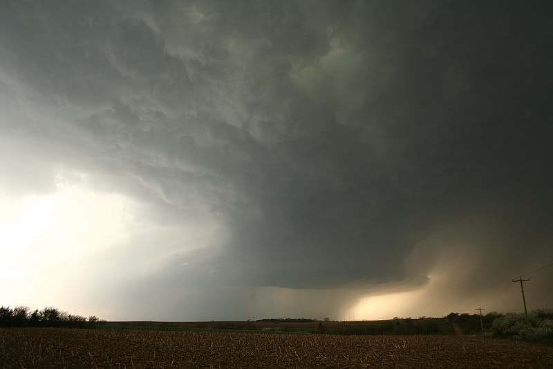
The damage path.....our location was 1 m. west of Sterling NE.
I wish I could remember chase accounts like you do. I was uploading pics to my site the other day and aborted mission due to a lack of memory of the specific things I like to write about. Great account and video!
It was crazy in there, we got caught up in that downdraft after filming the Tornado South of Beatrice, the visibility was zip, in there, at one point we were within 50 yards of the Tornado, and the rain curtains were insane.


3 comments:
I wish I could remember chase accounts like you do. I was uploading pics to my site the other day and aborted mission due to a lack of memory of the specific things I like to write about.
Great account and video!
It was crazy in there, we got caught up in that downdraft after filming the Tornado South of Beatrice, the visibility was zip, in there, at one point we were within 50 yards of the Tornado, and the rain curtains were insane.
I'd like to write a chase report for my interecept of the Beatrice tornado, but I can't seem to find my video..... I wonder where it could be?
Post a Comment