Email me at midwesternmeso (AT) hotmail [DOT] com

Please note: All images and videos on this blog are copyrighted by myself and may not be used without written permission. Any persons or entities who do not seek written permission will be held liable for copyright infringement(s) and will be subject to monetary compensation not to exceed $150,000 USD. (In pursuant to 17 USC Section 504(b) and (c), 17 USC Section 505.)

Tuesday, June 03, 2008

5/22/08 - 5/23/08 Photos....Wedding Photo

Still working on some more photos from 5/23/08...

Wide angle on the Quinter cone:


Quinter cone, ropeout stage on 5/23:


Hodgeman County, dual mesos....(I f'd up bad on this storm)...the one closes kept spitting out funnels, as did the one that was backlit...


The Greensburg supercell that supposedly had a large/extremely dangerous tornado on the ground...pic was taken just after the rotation went over Greensburg on 5/23:


And 5/22/08, first storm we got on just north of Dighton, KS:


We let it go after it nearly produces a tornado with a funnel, 3/4th to the ground...for this one just south of Dighton...funny, this is nearly on top of Derek's farm (Derek Shaffer, whom I was chasing with):


And taken from my ex girlfriend's house south of Amy...is it okay to cheer this spinup on? :)


And, a quick photo from the wedding on Saturday...tough, tough stuff to do in heat/humidity in such a small area as we were in a gazebo...this is Nicole, Devin's sister, and her father, Will...who will see this blog entry eventually I'm sure :) Nicole's new husband, Albert, chases with us from time to time and probably will this week.


Video of 5/22/08 is done editing, and should be up later today...

Monday, June 02, 2008

Severe Thunderstorms Move Through Olathe, Kansas City areas

Some strong wording from EAX just a bit ago:

KSC107-121-021800-
/O.CON.KEAX.SV.W.0105.000000T0000Z-080602T1800Z/
MIAMI KS-LINN KS-
1237 PM CDT MON JUN 2 2008

...A SEVERE THUNDERSTORM WARNING REMAINS IN EFFECT FOR NORTHWESTERN
LINN AND MIAMI COUNTIES IN EAST CENTRAL KANSAS UNTIL 100 PM CDT...

AT 1235 PM CDT...A LINE OF SEVERE THUNDERSTORMS WERE REPORTED...
PRODUCING GOLF BALL SIZE HAIL...AND DESTRUCTIVE HURRICANE FORCE
WINDS IN EXCESS OF 80 MPH. ACTIVATION OF LOCAL WARNING SYSTEMS IS
RECOMMENDED.
THESE STORMS WERE LOCATED ALONG A LINE EXTENDING FROM 7
MILES SOUTH OF EDGERTON TO OSAWATOMIE TO 6 MILES SOUTHWEST OF
OSAWATOMIE...MOVING SOUTHEAST AT 35 MPH.

SEVERE THUNDERSTORMS WILL BE NEAR...
FONTANA BY 1245 PM CDT.
PAOLA AND PARKER BY 1250 PM CDT.


It looks like there is also a moderate risk of severe weather as well. Softball sized hail was reported near Manhattan and Waverly, with baseballs everywhere else along the way. My poor dog, Roxie is afraid of the thunder, and cries when it rattles the house, but she's usually okay when I am with her. :(


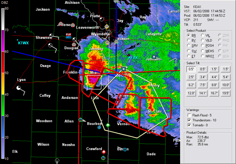
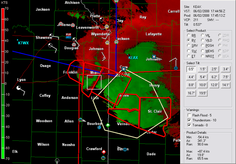
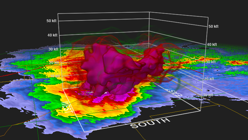
Some GR Level 2 analyst shots, Reflectivity, velocity, and then hail detect at 1744z (12:44 p.m.) I love the new high resolution radar...!


I'm getting ready to chase the next several days and am going to get this damn video edited SOON from the 22nd, and 23rd.

Contact Me

Contact me @
midwesternmeso AT hotmail (DOT) COM

wibiya widget