I finally got around to uploading all of the "Aurora" footage, I forgot how much we filmed before the actual tornado. We actually ran out of tape halfway through the Aurora tornado and you'll probably see where on there, but Darin was quick to the draw, so we only lost a few seconds. I really love our suction mount for our video camera that we purchased this year, it eliminates a lot of handheld shakiness and allows for some great time lapses. Next year, we plan on using this same camera and mount, and adding the amazing Sony FX1000 for better quality footage...having the old camera for wide angle structure time lapses and the FX1000 for the handheld zoomed stuff.
This supercell, before the infamous Aurora tornado, was oh-so-close to putting down a tornado in the city of Grand Island, which wouldn't have been good for their somewhat decent populated area, and fortunately didn't. We filmed an occluding meso that produced brief funnels beneath a wall cloud on the east side of Grand Island in the Wal-Mart parking lot, as it approached us about 1/2 - 1 mile to our west. We ran into Mike Hollingshead, saw Scott McPartland and Dave Lewison as well, who were also filming the show over Grand Island.
I would have had more time lapse footage, after the first scene you'll see, but for some reason that suction mount wasn't on tight, or the wind was moving my car and mount side to side, and it was rather annoying, so I left it out.
This took forever to render in Pinnacle, BTW. It only allows a 5x speed, so I had to chop each scene, then render it as the original .m2v file...which only wrote 1-3 frames per second...and each scene probably had 10,000 frames. So then I'd render it that way, then have to render it once again to get it to 10 x, before finally rendering the entire project. Fun stuff. The video isn't in it's native resolution mainly because Vimeo only allows me 500 mb, and the native resolution for this file was 700 mb. So I had to take it a notch down to 1200 x whatever instead of 1440 x 900 (1080i). And then vimeo resizes it to like 640 x 360. It still looks good, much better than any other format.
I'd embed the video on here, but they won't allow you to view it in HD other than their site, so here's the link to the video. I've also enabled it so that anyone can download the original source video on there, and the file is huge at 425 mb, but well worth it vs. the smaller version on vimeo.
Friday, September 25, 2009
Wednesday, September 23, 2009
Top Storm Photos of 2009
Even though there might be a small chance for severe weather in the next week or two, I thought I'd post my favorite storm photos of 2009. I was lucky enough to capture some decent shots in 2009, especially tornadoes. And despite the crappy year that a lot of chasers have had, we've had probably our best year yet...intercepting tornadoes in every month from March until July. Here is a link to last year's top photos.
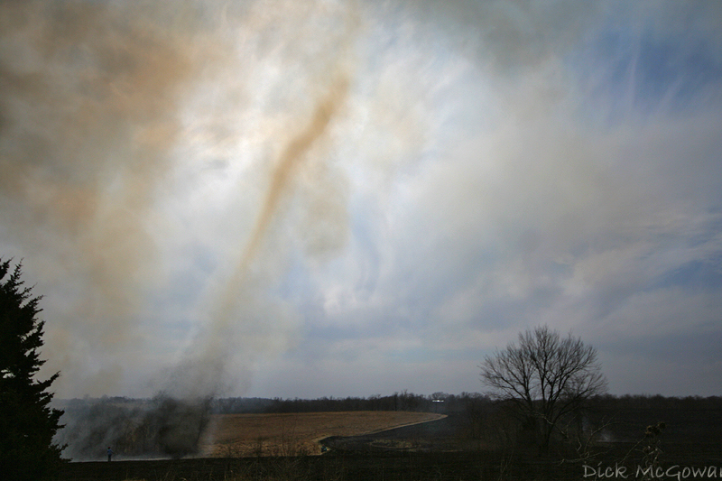
A 'firenado' back on March 6th, almost as good as the real thing up close:
April 26th, near Roll/Crawford, OK:
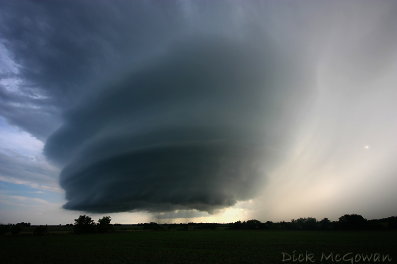
May 6th, 2009 in Linn County, KS a brilliant sunlit wall cloud and rainbow beneath a low-topped supercell...one that didn't even make it into the reports, but is forever etched into my mind:
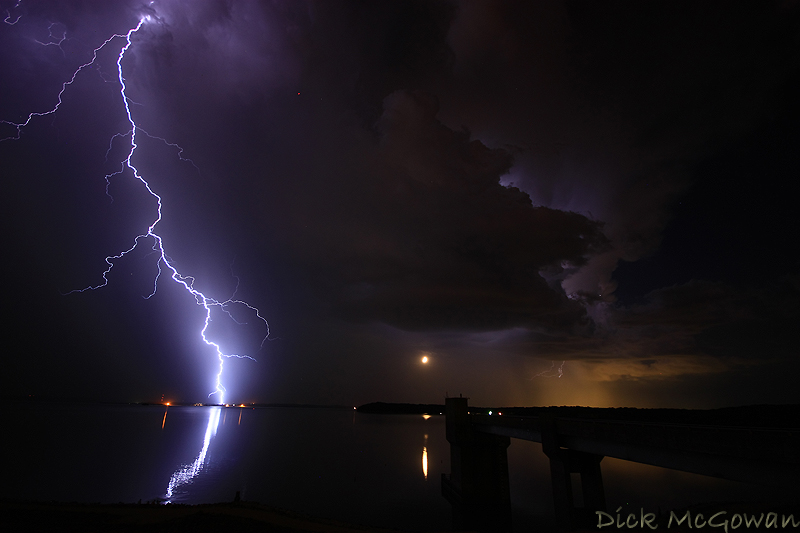
May 30th, Clinton Lake Dam, KS, Lightning shot with the moon setting underneath the updraft :
June 15th, 2009 near Kinsley, KS:
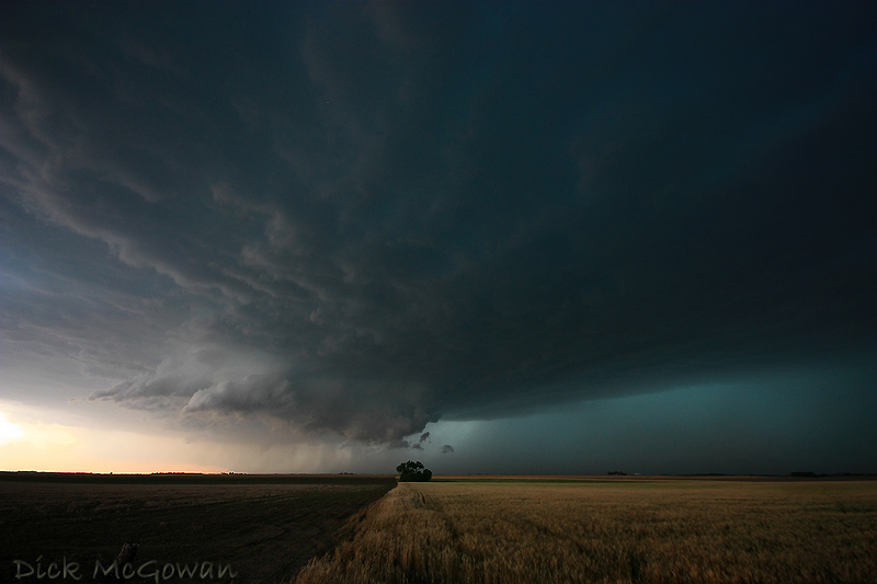
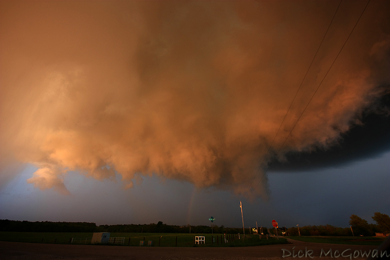
June 17th, amazing structure just west of Grand Island, Nebraska (wish I were just about 2 miles further east) :
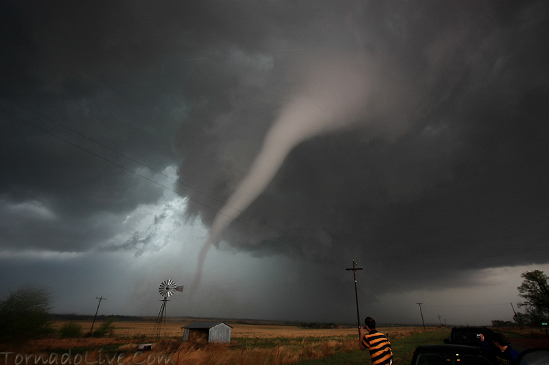
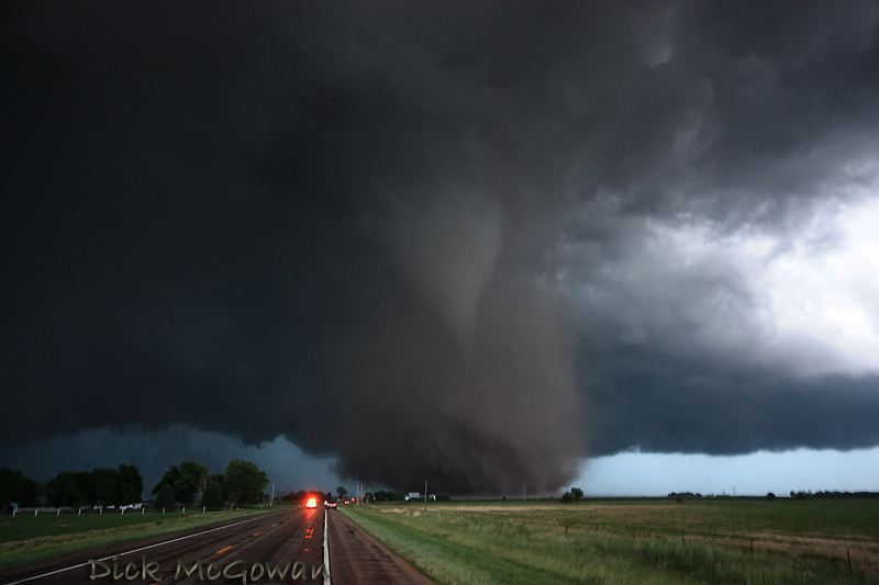
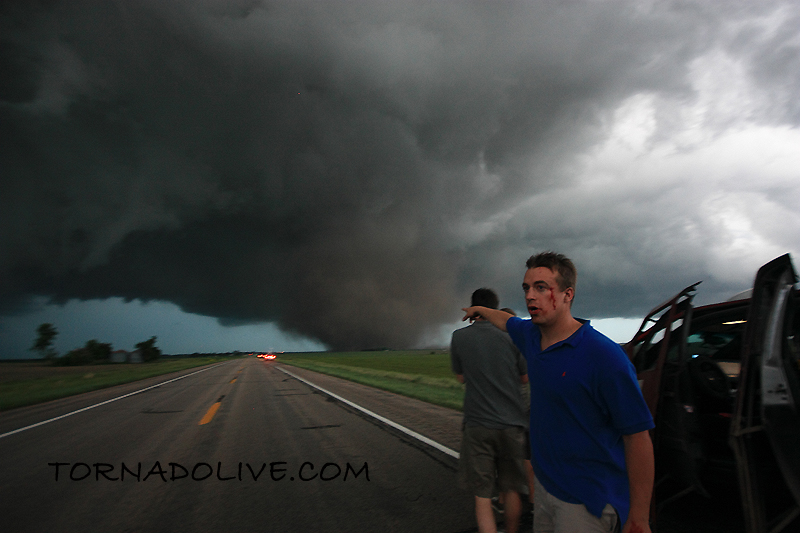
June 17th, the Aurora, Nebraska tornado as it begins to cross back north of the highway...a few miles west of Aurora:
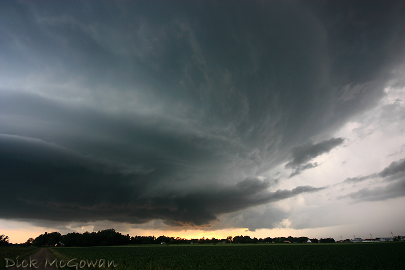
June 20th, Princeton Kansas 'mothership' supercell which produced several, weak, brief tornadoes, but the structure stole the show:
A 'firenado' back on March 6th, almost as good as the real thing up close:
April 26th, near Roll/Crawford, OK:
May 6th, 2009 in Linn County, KS a brilliant sunlit wall cloud and rainbow beneath a low-topped supercell...one that didn't even make it into the reports, but is forever etched into my mind:
May 30th, Clinton Lake Dam, KS, Lightning shot with the moon setting underneath the updraft :
June 15th, 2009 near Kinsley, KS:
June 17th, amazing structure just west of Grand Island, Nebraska (wish I were just about 2 miles further east) :
June 17th, the Aurora, Nebraska tornado as it begins to cross back north of the highway...a few miles west of Aurora:
June 20th, Princeton Kansas 'mothership' supercell which produced several, weak, brief tornadoes, but the structure stole the show:
Monday, September 07, 2009
Storm Chasers Show
Here is a preview:
Here's a fact you probably didn't know about Reed: He paid for his new vehicle out of his own pocket!
Brandon Ivey and Matt Hughes will be on the show this year too, who are a couple of chaser friends near the Wichita, Kansas area. Brandon is a stand-up, laid-back guy who I always give hell to about how close he seems to get to tornadoes after dark (via radar). Matt is also a great guy and together, make solid forecasts on tricky days and seem to always bag the good stuff.
Despite the crappy year for most(not for us!), there will be some unbelievable footage on the show. Reed and crew nailed every single major day this year (April 26, April 29, May 13th, June 5, June 15th, June 17th) and took direct hits from tornadoes on 3 of those days...2 of those...they were the first ever to scan the vertical wind shear inside of a tornado. Data collected from all of these intercepts, including the radar data, will eventually help save lives in the future from tornadoes.
In other news, I have just found out via printing at whcc.com that my monitor is way off on calibration. So if your monitor is calibrated correctly, my images probably seem very dark. To fix this problem, I'm calibrating it today with a ridiculously expensive program, so that I can print some photos in the future.
Subscribe to:
Posts (Atom)