This is from the first tornado that was a cone here, but matured into a very stout perfect stovepipe similar to one photographed by Eric Nguyen on June 10, 2004.

Then,this would be right after the first touchdown of the "Greensburg" tornado as it hit several power lines while dancing back up and down. In the video, it looks like we are further away, but as you know, it is closer than it appears. I'd say it was probably about 500 yards at this point.

We gain a little ground on it, as the storm is not moving very quickly, but we aren't either on this extremely muddy road. It's just over on the other side of that hill there now, while the first tornado picture I posted, has now morphed into a stovepipe about 4 miles to our west/northwest. The transition from a truncated cone to a stovepipe is literally seconds, it was doing a lot in between even frequent lightning flashes. It literally grows in size between flashes, and is now a very strong tornado that is still hitting power lines.

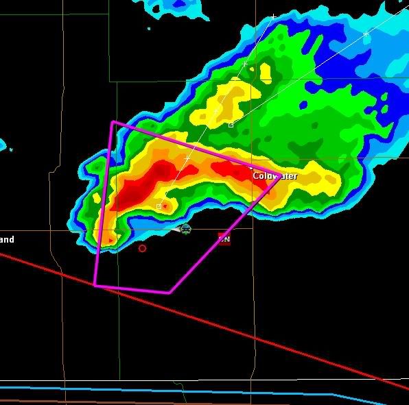
Here is a shot of GRlevel 3 with us as the green dot with the arrow pointed to the left (west) and the spotter network sign (red SN) in relation to the tornado-warned storm. It had been warned for about 10 minutes prior to this, going from a weak rain shower to a tornado warned storm in less than 5 scans (I'm guessing). Note the two areas of rotation there with the "double hook."
Lastly, here is a promo of a Greensburg documentary that we are going to be in. KSN (NBC) in Wichita has donated the producers our footage without our permission. After speaking with them, I am providing them with proof that it was ours, and that they unlawfully donated footage which they were only supposed to broadcast (via CNN). I'm not sure of their motives, but action will be pursued in the near future.
6 comments:
Who produced this documentary on Greensburg, KS. Did KSN make this film or was it done by an outside company. Do you know where to get a full version copy at? thanks you.
Great account! Thanks for posting. Looking forward to the doc and seeing your contribution. Should be very interesting.
Thanks Steve,
Hopefully it gets picked up by PBS, the guy who is doing it was just nominated for an Emmy in Chicago for his first film "Poverty in Chicago."
I probably won't watch it, because I hate seeing myself in pictures, let alone video!
He just interviewed us and we kind of retraced our steps that night, telling him what had happened and what was going on.
Going back and getting video grabs of night tornadoes always gives me the creeps, because, in the moment, they never seem to be quite as scary looking as they do when you go back and get video grabs later and get a GOOD look at what you were close to.
Dick,
Grab #3 is a beauty. I remember that exact flash of lightning (especially since lightning was rare early on)... it was one I wasn't able to catch in my viewfinder.
Dave,
No shit, it's so hard to tell what you are looking at in between flashes, then your mind thinks.....is that closer or further away then what I'm thinking! Before this, Darin was filming the one to the NW, while Derek and I kept telling him, "Darin, there's a funnel coming down right over the top of us." He finally said something a minute later, and we just laughed. There was so much going on in the sky then what we were seeing, and it really gives me the chills to think of what could have happened if the Greensburg tornado was further west.
Andy,
I really didn't see much of that tornado until the NW one wrapped in rain. Darin started to film the other one and I was concentrating on watching the road and adjusting to the RFD which kept pushing us into the ditch. I remember thinking, man, this is my dream tornado (Like Eric Nguyen's), and it's freaking dark.
You have the only photo I have seen of that Wizard of Oz tornado. I would have never seen it, had Derek not said something about it (about the time we honked at you) and I looked back.
Eric Whitehill and Beau G. followed that NW one and missed the Greensburg one. They were pretty close to it I guess and could hear the roar. It paralleled 34 highway on the east side of it.
Post a Comment