Email me at midwesternmeso (AT) hotmail [DOT] com

Please note: All images and videos on this blog are copyrighted by myself and may not be used without written permission. Any persons or entities who do not seek written permission will be held liable for copyright infringement(s) and will be subject to monetary compensation not to exceed $150,000 USD. (In pursuant to 17 USC Section 504(b) and (c), 17 USC Section 505.)

Monday, December 06, 2010

June 10th Photo

It's been awhile since I've posted! I don't have much to say other than I was in Los Angeles in late October with TVN while they did their promotional tour. We had a blast! It's almost winter time, so hibernating is probably what I'll be doing until spring. I'll occasionally post some photos of this year, if I have time. This blog will eventually be dead whenever we get the new website up.

Below is a photo I shot of a beautiful supercell in Eastern Colorado on June 10th of this year. (If you look closely in the foreground, you'll see Robert Seaman filming for the Storm Chasers show) This is why I chase.

Edit: The Facebook link on the right doesn't work right now......I've temporarily deactivated my account until the first chase of the season.

Colorado Supercell

Saturday, October 02, 2010

Kansas State Record for Hail Video

I'm not the greatest videographer, but here's the September 15th Video I shot with the 5D Mark II of the hail storm in Goddard, Kansas. Listen at 1:05-1:07 as you can hear a stone whizzing through the air before it impacts. I'm beginning to think around 8 inches is all the world will ever be able to successfully measure as larger stones will not be able to hold as they impact, unless the ground is saturated and can absorb them somehow. There were stones >8 inches.....probably a 10" one somewhere that day, but for now 7.75 inches is where the Kansas state record hail stone will stand!


See my previous blog post for pictures of this storm after the video!

Tuesday, September 28, 2010

2011 Weather Calendar

The 2011 Weather Calendar I helped create is available for purchase now. I think all but 2 shots are my pictures, if anyone is interested. They are on sale for $9.95 and can be shipped internationally, if needed!

Calendar_May 22_1

Sunday, September 19, 2010

September stands for Structure?

I've seen better storm structure in the last couple of weeks than I have in May or June some years.

September 1st - near Hoisington, Kansas: This nearly stationary supercell provided nearly 4 hours of eye candy and moved perhaps 15 miles. Got some great time-lapse footage of this.

Hoisington_web

September 15th - from Goddard, KS to east of Winfield, KS: Witnessed state-record sized hail (not that it matters...but I can almost guarantee world record hail fell within feet of my location, I just didn't have the sack to jump out and get one). Saw several gustnadoes and one brief, fully condensed tornado near Mulvane...followed by this amazing structure at dusk east of Winfield, KS. Was EXTREMELY sick this day...but couldn't sit it out, especially when I had the day off.

Winfield_web

Supercell_Sunflower_1


September 18th - Ozawkie, Kansas: Northeast Kansas is really worse than Iowa, but for some reason it provided some decent structure and one attempt at tornadogenesis before gusting out.

Ozawkie_web

Monday, August 30, 2010

Couple of Shots, TVN Calendar

Here are a couple of shots from the last chase, one a panoramic, the other at initiation. I have a lot more from this day I'll eventually get around to posting as well.

Flint_Hills_pano_web

Salina_LP_1

Chris Chittick and I have been working on and now have sent off the proofs for a TVN calendar which should be available by early next week. It includes a lot of my photographs (all but 2 I believe) and contains my best photograph to date in it on May 22nd...which I can not share on the internet until after the episode airs!

I'll probably make a post when it's available online to purchase for anyone interested. I'm pretty excited since I've never really sold any of my photographs for others to purchase.

Saturday, August 21, 2010

Shelf Cloud Panoramas

Below, are some attempts at panoramic photos of shelf clouds I've taken this year. The first in Nebraska near Columbus and the second just west of Quincy, Illinois. I didn't shoot them vertical, but rather horizontal, and I think they turned out alright...with maybe the exception of the Quincy one, since the 16-35 lens I was shooting shows distortion on the horizon from the wide angle.

Had another great storm photo day yesterday, where I chased a SE moving supercell from Salina, KS into the Flint Hills. Had no GPS on my laptop, so keeping up with it through the Flint Hills was quite a challenge. I lost count on the dead end roads and one-lane Farmer Bob roads I took; thank God they weren't muddy! No time-lapses, but shot more panoramic photos of a stunning shelf cloud at sunset. The supercell actually made one attempt at tornadogenesis as the RFD surged and wrapped around the north side close to the K-4 / K-15 intersection, before gusting out.

After that, an amazing sunset with golden fields emerged, as the decaying storm left a variety of colors on the backside. I must have taken 500 pictures yesterday, not wanting to miss anything. The Flint Hills are really a hidden gem in Kansas, and adding a photogenic storm to things at sunset really makes things serene. I was chasing solo and really wished I had someone there to share how amazing it was, but sometimes it's probably better to be alone. Pictures of yesterday at some point.

shelf_panorama

pano_web

Tuesday, August 17, 2010

Recent Lightning Shots

After living on the road with the TVN crew for several months (and driving 25,000 + miles), I've returned back to my normal life and it just isn't quite as exciting. So I venture out on these 'under the ridge' days, (where pulse storms generally form from just heat and a weak cap...or from enough convergence along an old outflow boundary/ weak cold front) and try to regain that same intensity as before, but I generally just get disappointed.

I've been focusing on doing more time-lapse photography with the 5D Mark II and using an intervalometer which is amazing and I'll probably make a video in the next couple of years. The plan for 2011, is re-join the TVN crew till around the middle of June, then venture out solo for a couple of months after that--chasing the Northern Plains and Canada for slower moving storms/supercells and doing strictly time-lapse photography of everything I encounter.

Below are some lightning photos I've taken in the past couple of weeks...more to come at some point. You can catch my other blog posts over at tornadovideos.net as well,as I'm assisting over there when needed.

Sunset_Desoto_1

FlintHills_web

Lightning_1

Thursday, August 12, 2010

Yazoo City, MS Damage Panorama

yazoo_panorama

Above is a panorama of the Yazoo City, MS tornado damage taken on April 24th, 2010 approximately 3 hours after the EF-4 tornado tore through the city. We were on 2-3 hours of sleep in 72 hours time, after driving from the Texas Panhandle to SW Iowa, then to Mississippi virtually non stop. We drove well over 2,300 miles in this time frame. The tornado was extremely rain-wrapped and moving at a dangerous 65 mph. We had a very close call, but luckily avoided the tornado. It was very sad to see such devastation once again and a day many of us will never forget.

Tuesday, July 13, 2010

More Photos from This Spring


I'm gonna have to re-arrange this blog to make room for the bigger sizes I've done at some point, so it'll probably look a little funky till then. I'm not exactly a web designer either! Speaking of websites, now that Reed and I have a little more time, we plan on getting the new website up in the coming months.

And since 90 percent of my images have either the TVN crew or Dominator in them (being behind them all the time), they won't permit me to upload those photos until the show/episodes have aired. Being the driver, and as much as we could never stop due to the constant attempts at intercepting the tornado, much of these were taken while driving.

Tuesday, June 15, 2010

Another Amazing Day....

More to come in the next several weeks as I have more time...as the season winds down. Best structure + tornado I've ever seen along with best rope-out as well. It doesn't get much better than this. Also observed softball-sized hail which manhandled our vehicles. Made the mistake of shooting jpeg vs. RAW for these pictures and shot + 1/3 stop a little too high (shooting this from the sitting position on the south side of the vehicle as 2 inch stones were carried from the northeast). It was not fun trying to get back in.

Colorado_Hose1

Colorado_Hose2

Sunday, May 30, 2010

Update, Matt Hughes

Brief update here, we've intercepted approximately 22 tornadoes since my last blog post. Here's one of the pictures (I have probably 500 more that I'll show at some point). Check out another one here on Discovery's website.

Below is a picture west of Aberdeen, SD on May 22. Click here for larger version.
South Dakota Rope Tornado

Matt Hughes, of The Storm Report, passed away on Wednesday. Matt was a great friend, an amazing father and a great storm chaser. His funeral will be held on Tuesday in Valley Center, KS. I'll write more about this later when I get time. My thoughts and prayers are with his family and friends.

Tuesday, May 04, 2010

Quick Update

Wow, almost 6 months since I've updated this! It's been a crazy April, so far, witnessing/documenting a legitimate 11 tornadoes and hopefully more coming this week. If you are still following this blog, the best way to keep up with me is through my facebook page where I'm updating pictures/updates on storm chasing throughout the Spring.

I've been chasing with the TVN team this Spring and will continue to do so until at least mid-June, so check out their LIVE streaming page to follow us on our live storm chasing journey this Spring. Looks like a marginal chase this Thursday (we've been chasing everything) and things really start to ramp up by the end of the weekend into early next week.

Below are some photos I've taken this Spring of storm chases, with about 20 gigs more to process as I write this. Unfortunately, we were in Yazoo City, MS minutes after the tornado struck the town and below is a picture of the actual tornado. Last Friday, we also witnessed the deadly Scotland, AR tornado as well. It never gets easier seeing the destruction and chaos first hand. Seeing the Yazoo City damage/chaos really brought me back to the Greensburg, KS tornado, which just happens to be the 3 year anniversary of it today. It's pretty difficult to put into words, photos, or even video of what it's really like.

This is only my 3rd day off since beginning this trip a month ago, and will be remembering all of the victims of the violent tornadoes I've witnessed over the past three years.

New website is still under construction but should have it up in the next month or two.

I have a new camera and a variety of solid lenses, but am having trouble accessing the RAW files, but will be updating my facebook page/flickr soon once I get things resolved. Tornado pics, structure, damage photos to be uploaded soon.

Dick

Yazoo City, Mississippi Tornado

Belleville, KS Supercell

Texas Supercell

Friday, November 20, 2009

Hi

It's been awhile since I've posted; I've been pretty busy as usual lately and haven't had time to post much. I'll probably be shutting this blog down within the next few months and will be creating a better-designed one on a new site/blog, so when that is all completed and finalized, I'll post the link on here. I'm hoping to own the Canon 5D Mark II by January/February and ditch my other cameras and lenses (minus the 100-400L) for the Canon 17-40L, the 24-105L (or 24-70L) to compliment the new camera...and am very excited about it.

Here are a few new photos I've recently processed and another reason I can't wait to ditch this POS Sigma 17-70 lens, which fails me nearly every time;

Virga

Virga

Virga

I'll still be updating this blog till the new one is up...

Friday, September 25, 2009

Supercell and Tornado Timelapse

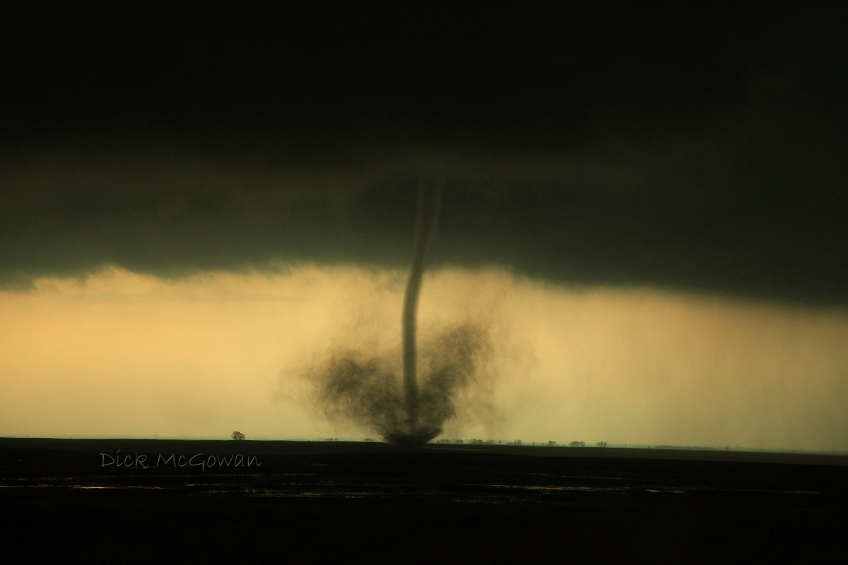
I finally got around to uploading all of the "Aurora" footage, I forgot how much we filmed before the actual tornado. We actually ran out of tape halfway through the Aurora tornado and you'll probably see where on there, but Darin was quick to the draw, so we only lost a few seconds. I really love our suction mount for our video camera that we purchased this year, it eliminates a lot of handheld shakiness and allows for some great time lapses. Next year, we plan on using this same camera and mount, and adding the amazing Sony FX1000 for better quality footage...having the old camera for wide angle structure time lapses and the FX1000 for the handheld zoomed stuff.

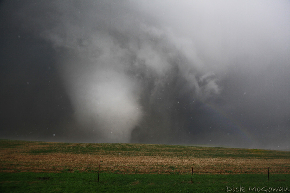
This supercell, before the infamous Aurora tornado, was oh-so-close to putting down a tornado in the city of Grand Island, which wouldn't have been good for their somewhat decent populated area, and fortunately didn't. We filmed an occluding meso that produced brief funnels beneath a wall cloud on the east side of Grand Island in the Wal-Mart parking lot, as it approached us about 1/2 - 1 mile to our west. We ran into Mike Hollingshead, saw Scott McPartland and Dave Lewison as well, who were also filming the show over Grand Island.

I would have had more time lapse footage, after the first scene you'll see, but for some reason that suction mount wasn't on tight, or the wind was moving my car and mount side to side, and it was rather annoying, so I left it out.

This took forever to render in Pinnacle, BTW. It only allows a 5x speed, so I had to chop each scene, then render it as the original .m2v file...which only wrote 1-3 frames per second...and each scene probably had 10,000 frames. So then I'd render it that way, then have to render it once again to get it to 10 x, before finally rendering the entire project. Fun stuff. The video isn't in it's native resolution mainly because Vimeo only allows me 500 mb, and the native resolution for this file was 700 mb. So I had to take it a notch down to 1200 x whatever instead of 1440 x 900 (1080i). And then vimeo resizes it to like 640 x 360. It still looks good, much better than any other format.

I'd embed the video on here, but they won't allow you to view it in HD other than their site, so here's the link to the video. I've also enabled it so that anyone can download the original source video on there, and the file is huge at 425 mb, but well worth it vs. the smaller version on vimeo.

Wednesday, September 23, 2009

Top Storm Photos of 2009

Even though there might be a small chance for severe weather in the next week or two, I thought I'd post my favorite storm photos of 2009. I was lucky enough to capture some decent shots in 2009, especially tornadoes. And despite the crappy year that a lot of chasers have had, we've had probably our best year yet...intercepting tornadoes in every month from March until July. Here is a link to last year's top photos.

A 'firenado' back on March 6th, almost as good as the real thing up close:

Firenado

April 26th, near Roll/Crawford, OK:

Roll Oklahoma Tornado

May 6th, 2009 in Linn County, KS a brilliant sunlit wall cloud and rainbow beneath a low-topped supercell...one that didn't even make it into the reports, but is forever etched into my mind:

Linn County Low-Topped Supercell + Wall Cloud

May 30th, Clinton Lake Dam, KS, Lightning shot with the moon setting underneath the updraft :

Clinton Dam Lightning + Moon

June 15th, 2009 near Kinsley, KS:

06152009_02web

June 17th, amazing structure just west of Grand Island, Nebraska (wish I were just about 2 miles further east) :

Grand Island, Nebraska Supercell

June 17th, the Aurora, Nebraska tornado as it begins to cross back north of the highway...a few miles west of Aurora:

Aurora, Nebraska Tornado

June 20th, Princeton Kansas 'mothership' supercell which produced several, weak, brief tornadoes, but the structure stole the show:

Princeton, KS supercell

Monday, September 07, 2009

Storm Chasers Show

Reed Timmer + Aurora, Nebraska Tornado

Here is a preview:


Here's a fact you probably didn't know about Reed: He paid for his new vehicle out of his own pocket!

Brandon Ivey and Matt Hughes will be on the show this year too, who are a couple of chaser friends near the Wichita, Kansas area. Brandon is a stand-up, laid-back guy who I always give hell to about how close he seems to get to tornadoes after dark (via radar). Matt is also a great guy and together, make solid forecasts on tricky days and seem to always bag the good stuff.

Despite the crappy year for most(not for us!), there will be some unbelievable footage on the show. Reed and crew nailed every single major day this year (April 26, April 29, May 13th, June 5, June 15th, June 17th) and took direct hits from tornadoes on 3 of those days...2 of those...they were the first ever to scan the vertical wind shear inside of a tornado. Data collected from all of these intercepts, including the radar data, will eventually help save lives in the future from tornadoes.

In other news, I have just found out via printing at whcc.com that my monitor is way off on calibration. So if your monitor is calibrated correctly, my images probably seem very dark. To fix this problem, I'm calibrating it today with a ridiculously expensive program, so that I can print some photos in the future.

Monday, August 24, 2009

Lawrence, Kansas Lightning Photos

Shot these back on the 9th/10th and was one of the rare chances I've had shooting lightning (and nothing spectacular either). There never seemed to be a night where there were training storms around the KC-Lawrence area where I could go out and shoot for hours like there was last year...and if there was, I couldn't either shoot or the lightning was embedded within the rain cores.

To me, shooting lightning really takes no skill at all, other than keeping the rain off of your lens (which was tough this night as a small amount of mist would require me to wipe it off after each shot). I just judge the brightness of the bolts and how close they are, stop it down as desired (these were between f/5.6 - 9.0 on Tv mode), then fire off 30 second exposures. If you're lucky enough to not have any rain, then you could use a cheap shutter release cable, then set your camera to continuous shooting. And having that thing on, you could just walk away as it fires 30 second exposures off, continuously, so you don't miss a bolt. Luck and the right storms are what makes great lightning photos, great.

lawrencelightning02web

lawrencelightning04web

lawrencelightning03web

lawrencelightning07web

I handheld this one and got lucky:

lawrencelightning05web

I've been doing a lot of fishing lately with luck from time to time and have decided I need a boat badly. I plan on purchasing one over the winter hopefully to use in the early spring and for summer (obviously not much between April, May and June ;) ).

There's not much hope for severe weather in the next 10 days either as the current long range models are showing. I'm pretty anti-hurricane as the eye candy appeal isn't as great as it is with supercells. I could careless to chase one any time soon or even learn more about them. Wind...lots of wind...for hours isn't my cup of tea. If I wanted to experience that, I'd drive into squall lines more often! It seems as though hurricane chasing is more of a survival-of-the-fittest among those who chase them. Yawn. Just give me a slow-moving, striated supercell in Western Kansas on any day and I'll take that over a Cat 5 cane over New York City.

Thursday, August 13, 2009

Perseid Meteor Shower 2009

A friend and I went fishing a couple of nights ago on the evening the Perseid Meteor shower peak was supposed to happen (August 11-12). I caught 8 catfish, he caught zero :). Anyways, couldn't really see any near the Spring Hill lake we were at and left there about 11 p.m. and headed back out at 12 a.m. for the "big show" on top of the dam at Melvern Lake about an hour SW of here. One has to get away from the light pollution in major metro areas for the best viewing. So that looked like an ideal spot to view them and for the most part was. Unfortunately, a half moon rose around 10, and really killed the potential for seeing really bright ones.

Nevertheless, I caught 5 on the camera, shooting at 1600 ISO (800 wouldn't show up) at f/2.8. I tried 1600 ISO at f/4 on the old XT with the Sigma 10-20 lens and caught nothing. It was super nice out, light breeze, 70 degrees, no clouds, only a moon that destroyed some great meteor potential and forced me to shoot shorter exposures while loading up my 4 gig SD card quickly. The Xsi battery died after about 3 hours of shooting, so I had to switch to the XT for about 45 minutes (I'm never prepared lol).

Just before dawn, I was setting up for the northern horizon because I knew it would be sweet to get one with some morning light in it. As I was setting up, Derek yelled to look up and an earth grazer shot clear across the sky from the NW to where it ended in the NE. It was the best one of the night, figures.

And last night, I was outside for maybe 20 minutes and saw at least 5 incredible, fireballs from the city, which were brighter than most I saw the night before. According to others, last night was much better for viewing the Perseids. Sigh. Maybe next year I'll be more prepared and try to choose a better location with something cooler for the foreground. Here are a few shots from 1 a.m. - 5:30 a.m. on August 12th.

Full size, no crop at 17 mm:

Perseid Meteor Shower

~ 75% crop on a different (more faint) one:

Perseid Meteor Shower

~ 50% crop with two meteors in the same shot:

Perseid Meteor Shower

Our viewing area from the dam:

Perseid Meteor Shower

I shot some decent lightning photos around midnight on the 10th that I'll be adding onto here sometime in the next week or so.

Tuesday, August 11, 2009

Photo of the Day, New HD Tornado Video

newaurora01web

Taken just west the Iams pet food plant (which was partially hit by the tornado) just west of Aurora, Nebraska on June 17th. The tornado slowly wraps in rain as it ropes out in front of us, and is shot at 10 mm. It still is mind-blowing of all of the chasers on this tornado on Spotter Network alone, yet only Jeff Snyder and ourselves reported it via it (we reported it twice). Makes you wonder why anyone uses this program other than, "Look at me guys, I'm on Spotter Network!"

Then April 26th, Roll/Crawford, Oklahoma tornadoes in HD is below (click on the HD button). I've been slowly working on a DVD that should be available sometime by the first of October of this year's chases, plus Greensburg tornado in 2007, Quinter, Manhattan tornadoes in 2008 and other dates that aren't coming to mind at the moment.

Thursday, July 30, 2009

Photo of the Day, Chasing Tomorrow

06292009_02web

I'm really running out of photos to post for this daily thing already, or ones I think are good enough to make this...but here's one I took a month ago out on the Clinton Dam near Lawrence, Kansas. I haven't taken hardly any photos in the past two weeks, haven't really had the desire to.

Tomorrow looks good for chasing in Western Kansas, and I'll likely be chasing it depending on tonight's runs. At worst, it looks like a good supercell or two somewhere in extreme Western Kansas. I'll just be glad to be back out on the road and that feeling you get in your stomach before a chase...

Contact Me

Contact me @
midwesternmeso AT hotmail (DOT) COM

wibiya widget