As we heard the report of a tornado over the wx radio near La Harpe touchdown, we assumed it was bullshit since we were just south of that location. Mike Hollingshead emailed Darin and I and showed us what we now believe is a second tornado just to our north buried in precip. It resembles a carrot and debris appears to be under the fully condensed funnel as we passed east of Iola. Hopefully Mike will add it back up on the his page at some point. And now to Thursday..........let the fun begin!
I've decided to apologize to Steve Miller for our recent, pointless arguing, as he made a good point that the storm chaser community is dividing, and the blog wars really get us nowhere. We all share that passion, and not once have I met a storm chaser I haven't liked, and I'm sure Steve would be no exception.
Thursday's setup has a shot at being a high risk. I posted my (what i call) "shit" forecast here . Still a couple days out, and my mind will change all the way up until we leave or are leaving. Either way a significant event is unfolding, and I do not feel like chasing storms moving fast into MO, it's a deathwish. I pray that no loss of life or property comes with this system, and wish good luck to everyone chasing out there on Thursday. Report everything! As storms will be moving fast, and 1 extra minute of warning could be the difference between life and death.
Dick
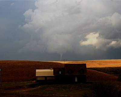
Pictured above is one of the cold-core tornadoes we grabbed on 11/27/05. I just redid it to enhance the structure and tube more. Very proud of this image with the house in the background. Not as good as Eric Nguyen's mulvane/house shot, but for an amateur like me, I'll take it.
No comments:
Post a Comment