Email me at midwesternmeso (AT) hotmail [DOT] com

Please note: All images and videos on this blog are copyrighted by myself and may not be used without written permission. Any persons or entities who do not seek written permission will be held liable for copyright infringement(s) and will be subject to monetary compensation not to exceed $150,000 USD. (In pursuant to 17 USC Section 504(b) and (c), 17 USC Section 505.)

Monday, April 27, 2009

More Roll, OK Tornado Photos

Edit:


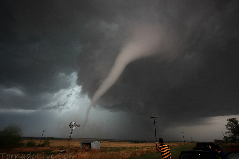
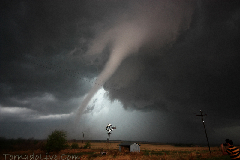
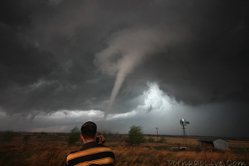
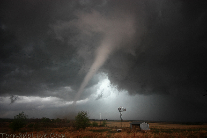
Below are a few stills of the elephant trunk tornado near Crawford / Roll, Oklahoma. I've also added an approximate (although I think it's within a few hundred feet) google map of where the tornadoes occurred which is here.

4_26_09_04web

4_26_09_02web

4_26_09_03web

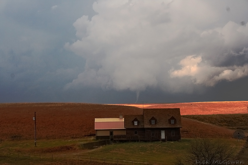
And this is a video capture of the 2nd tornado:


Storm chasing is 50 percent luck and anyone that tells you any different is a liar. I've waited 6 years to be this close safely, and we had to take advantage of it. As other veteran chasers have told me, an opportunity to film a photogenic tornado, up close, won't happen again for a long time and I believe them. Darin had to get on me (as you'll see in the video) to take pictures and I feel bad he shot the video and couldn't shoot stills either. We both never want to shoot the video and want to do stills, so next time it's my turn.

It's extremely difficult to shoot pictures/video in these tense situations as a lot of chasers know. I should have, like many have already told me, shot it without the powerlines. But safely, I don't think I could have with the hail, strong inflow winds, and the uncertainty of the tornado's path. Hindsight is 20/20. I had to bump the ISO to 400 to get a faster shutter speed, handheld, open the aperture (av mode) to f/4.0, adjust the exposure compensation to -2/3 and luckily exposed it correctly using the histogram, on the first try. Then framing it, manually focusing it all within 2-3 minutes that a fast-moving tornado is on the ground and under extreme conditions. Thankfully my brain is wired to my cameras functions and I can do this without thinking too much or taking too much time.

I look at the legendary Eric Nguyen's photos, and wonder how he consistently got those amazing shots just as close, time and time again. He is still missed greatly by his friends, family and chasers like myself who were inspired by his photography, who never really knew him.

It's hard to feel too excited on a day like today when you see something amazing and several of your chaser friends didn't. I can't tell you the number of times I've been on the other end, so I feel their pain. I used to get so depressed when we missed something amazing and somewhat jealous, but it doesn't matter to me any more. I've grown to feel happy for others (with the exception of a few assholes) bagging amazing stuff regardless if I'm there or not.

Enough ranting, I've got a lot more stills to process/upload of both the 25th and 26th, including more stills of the 2nd tornado.

Roll, Oklahoma Tornadoes

I'll elaborate more a little later today, but this was the first tornado Darin and I saw near Roll, Oklahoma. We sat in this exact spot for a good 20 minutes waiting on the storm and it happens to produce a tornado at extremely close range (within 200 yards tops). This is at 10 mm, the widest one can go without being a fisheye, my other lenses wouldn't have been able to fit the whole thing in. It's MUCH closer than this...more later including a 10 minute video of the whole day.


4_26_09_01web

Wednesday, April 22, 2009

Video Stream, Tracker and Shiny Toy Guns

Just a quick update here, I added a little widget at the top that will show our location when we're storm chasing. And if you click on the green car icon, it should display live video (when available, obviously).

I also added some new blog/website links to the bottom who have kindly linked me on theirs. If you're reading this and would like to have your website linked, just leave a comment on here and I'll add it.

Earlier this year I found out that the band Shiny Toy Guns, who are a pretty major band worldwide, and are in fact...storm chasers. I've been exchanging emails with the keyboardist who seems to know his stuff and hopefully we'll meet up before or after a chase this year (they are currently in Montreal Canada touring however, but have a break May 10 - 23 IIRC). Although they live in Los Angeles, two of the members are originally from Shawnee, OK and they tell me it's their "secret hobby" they have had for some time, while being full-time rock stars now.

I highly recommend checking out this amazing song/video here of theirs!

Below is a picture I shot of them chasing back on March 7th (and I wish I had known it was THEM at the time!), the black van with the lightbar is them with Oklahoma tags that reads "Shinys"

Although, so far, this weekend's set up looks "ok", we'll still be chasing Friday - Sunday, most likely, and I'll hopefully be posting updates more often now that the season is nearly in full swing.

The Band, "Shiny Toy Guns"

Monday, April 20, 2009

Old Photos

Well, I haven't really done much of any chasing this past week, although I should have on Saturday as a nice cold-core setup was in place for SW KS. In fact, Saturday's tornadoes were within 45 miles of where I grew up (Kalvesta, Kansas). I've been through Kalvesta about 1 million times in my life, so the area I'm quite familiar with. Jon Davies has a nice writeup here on his blog. Below are some photos of the cold-core tornado fest Darin and I were chasing on November 27, 2005 near Marion, Kansas. Easily one of my favorite chases ever.

Cold-core tornado with mini supercell

Cold-core tornado with mini supercell

November House Tornado

Cold-core tornado with mini supercell

There's no telling where or when the next setup will be, the models keep flip-flopping around. Perhaps late this week or early next week.

In other news, I'm growing tired of the competition that seems to grow bigger and bigger each year in the storm chasing world. It seems as if the number of storm chasers out there now are in this for the "attention" and "fame." While I've been offered and tempted by these, it will never be part of my agenda. New "chasers" are popping up each year with a data card, a live stream and an SPC target to drive to and who thrive to be like Sean Casey or now, Reed Timmer. The ability to make their own forecasts and taking the time to learn storm structure/behavior is now a past time.

Friday, April 10, 2009

Chase Video from 4/9/2009

Ignore my previous post about joining facebook to view it, it looks like they allow embedding now.

Murfreesbro Tornado Video and Yesterday's Chase Video

Edited at 9:45 p.m. for radar content


These are the best videos I've found out there of the April 10th tornado in Murfreesboro, Tennessee.

link


link


I don't have a lot of time to post, but yesterday, Darin Brunin, Andy Fischer and I chased a lot of garbage in SE KS and NE OK. We did catch a couple of funnels, but no tornadoes. We were actually viewing a wall cloud in the ghost town of Picher, OK which was significantly damaged last year by an EF-4 tornado...pretty eerie.

If you have a facebook account you can view the video I edited here. Just having a facebook account is good enough (so create a fake one if you don't have one) to view it. I upload videos there now, because facebook doesn't compress the quality like youtube does.

Below is the text of the tornado warning issued SW of Atlanta, Georgia.

AT 633 PM EDT...NATIONAL WEATHER SERVICE DOPPLER RADAR CONTINUED TO
INDICATE A TORNADO.
THIS TORNADO WAS LOCATED NEAR EPHESUS...MOVING
EAST AT 40 MPH. (Georgia)

THIS IS AN EXTREMELY DANGEROUS AND LIFE THREATENING SITUATION. THIS
STORM IS CAPABLE OF PRODUCING STRONG TO VIOLENT TORNADOES.

I have no doubt there have been some rare instances where intense couplets are observed on radar and one can assume this. But, can radar ever prove that there is/are strong to violent tornadoes in real-time? As we all know, radar can not scan to ground level.

Below is reflectivity using Level II data on the new super res radar (all are the scan times before the text was issued):


Using SPC's recommended mean storm motion vector of 27040, this is what it looks like on base velocity (BV) scan.


Same vector here using storm relative velocity (SRV)


I'm not a radar expert by any means, but that does not show (at least for using strong wording in the text) an indication for "strong or violent" tornadoes. I think that wording should be used when the one in charge has 1. an impressive velocity couplet is observed and 2. more than one source of ground confirmation has been provided by reputable, trained weather spotters.

I'm pretty sure this was the same NWS office issuing tornado emergencies (based on radar only, without visual confirmation, ground truth) for towns in their area a month or two back and those storms produced only EF-0 and EF-1 tornadoes. Maybe the next TE wording will have to include wording such as, "Tornado Apocalypse?" (They didn't issue any tornado emergencies this time, however).

Later on this evening, this different supercell (below) seemed to have a much better and more impressive couplet than the one above.


I don't give a shit either way, but throwing that wording around to the public/media over and over again and not having the proof to back it up, can only make the general public take you less seriously next time. Then the blame is then shifted right back to those meteorologists.

Monday, April 06, 2009

4/4/2009 Chase Account

J.B. Dixon, Darin and I left the Lincoln Weather Symposium around noon and were praying for a 50 dewpoint near the surface low, but couldn't ever manage better than a 43 or 45. It resulted in very high-based storms, many of which we intercepted just east of Red Cloud, Nebraska, by playing the NE part of the arc and ditched one for another, moving east, after one would move to the NW (which these storms, when moving to the NW, rarely produce tornadoes). It didn't matter anyways. The updrafts were fuzzy, not rock solid at all (like 11/27/05) and were extremely high-based. We got home at a decent hour, which was nice, after having about an hour of sleep in 28 consecutive hours.

Focus is now shifted to this Thursday for a chase in Eastern OK, SE Kansas. There's a possibility that I may be driving/navigating a lot more (than planned) for Reed's Chasing Tour company here in the upcoming weeks.

Below are a few pictures of Saturday's chase in SC/SW Nebraska.

Red Cloud Nebraska Storm


Wednesday, April 01, 2009

Storm Chase Account 3/30

Lebo, Kansas Shelf Cloud + Lightning

Marginal instability, unidirectional shear and an quickly-advancing cold front can only guarantee you one thing...shelf clouds...extremely high-based shelf clouds. Nevertheless, I had the day off, drove almost to Emporia, KS and saw some decent storm structure. The lighting, at sunset, was just enough for one to shoot a 3-5 second exposure and have enough sun peeking through the base to capture the structure and then have a chance at getting a lightning strike. My one and only lucky strike I shot was the only keeper of the night. I headed home as the storms weakened as they headed into more stable air (39 dewpoint here in Olathe). Brandon Ivey, further south, captured a gustnado in Cowley County. His video is here.

I'm still tornado-less in 2009, but am hoping for a chance to eliminate that on Saturday in Western Kansas.

In other chaser news, a "storm" chaser has been caught red-handed of manipulating a photo to show a tornado that wasn't there in a recent report on Stormtrack. It's out there if you look hard enough. Some advice to the guilty: If you're going to manipulate a photo to show that a tornado was in it, make sure there weren't 200 other storm chasers on it who were much closer and didn't see what you claimed to have.

Contact Me

Contact me @
midwesternmeso AT hotmail (DOT) COM

wibiya widget