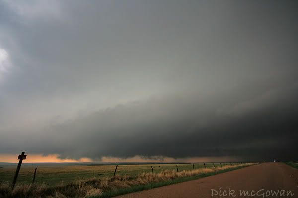
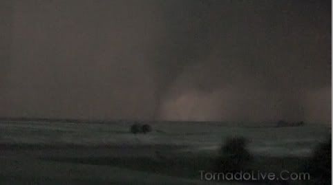
Reed Timmer's and Joel Taylor's incredible probe video they shot on Thursday night north of Beloit, KS.
That storm chaser getting hit by a tornado thread, has turned into a superior group of chaser's "safety thread." The same BS they say every year, only more rehearsed and blatantly obvious. Just say you f'd up and got hit, shit happens...don't try making excuses up. This is a damn hobby people, I can't get why some people are so obsessed with the image of a storm chaser or themselves. People stereotype every damn thing on the planet, there's no reason it will ever change.
Darin and I are shooting photos for a wedding here shortly, I hope I don't screw this up.
Saturday, May 31, 2008
Thursday, May 29, 2008
TornadoPalooza
Well, I decided at the last minute I shouldn't go after putting 3,000 miles on my car, windshield destroyed by a baseball, low on cash, etc. I still don't regret it, I get terrified night chasing now.
Darin, his girlfriend and his mother chased and saw at least a half dozen, strong to violent tornadoes, two times from close range. I was sending Darin pics of GR2 analyst and nowcasting for a mapless, dataless, Jordan, Doug and Josh. Please donate $.25 so they don't call me every 5 minutes.
Stovepipes, fat cones, multi vortex's, elephant trunks, wedges, ropes.....don't think Darin mentioned a barrel! Will have to double check on that.
I had fun nowcasting for nearly 6 hours. I told Doug to head to Red Cloud at 1 p.m. and he made it to west of Hebron, where he lost cell phone coverage and tried to catch the Kearney storm. I told him he'd never catch it, and that a southerly 55 llj with major upper level divergence/support on its way by 1z for the at-first HP storms. It was money near Osborne, as a structure HP mothership, slowly transitioned into a more classic mode with stronger anvil SR winds.
We all talked last night about picking the target few would take, and all agreed on central ks...I dont think Darin saw many chasers till dusk, when a lot headed south.
Incredible night, congrats to Lexy, Darin's mother, Darin, Doug, Jordan, Josh and the others who witnessed the supercell of the year. SPC's downgrade from high to moderate surely clinched the fate of this cyclic long tracked monster.
Darin's last cone was the most photogenic he said, I'm eager to see the video as well as other chasers :) and Doug and Josh's direct hit from an elephant trunk with BOTH probes deployed successfully, while the mesonets recorded the pressure drops. Insanity.
What a day, I"m excited and I wasn't even there. I'm sure Darin's tornadopalooza will be up soon.
Yahoo out.
Edit: I took out those who were hit by the tornado who haven't posted about it, Chris Collura, Reed Timmer and Joel Taylor deployed their probe and another probe was launched I think by another known chaser. Two probes, one tornado! Mesonet cars measured the pressure drop, Chris Collura has pretty crazy photos, including IMO best structure shot of all time...posted on Stormtrack here.
Chris has seen just about every tornado there has been in the last 2 weeks, has to be a dream season for him, he's bagging tornadoes left and right, and had at least 2 very close calls now.
Still am not regretting my decision to sit this one out, 2 years ago I would be slamming a fifth of some Herra-Derra. Incredible storm, mesoanalysis is so much easier to monitor when you're relaxing with the AC on on broadband!
Amos apologized to the DOW's for pulling out in front of them...hilarious, since that's all I ever see them doing. Probably a huge rush for their caravan to do that and see how close one can come to causing an 18 car pileup in BFE Gove county. Thursday, drove away from a wall cloud in Dighton, Friday the TIV never saw the Quinter cone blasted west...hail core must have looked amazing or maybe they don't have side windows. Then, they scan a storm from 50 miles away and the cameraman act like it's 100 yards away getting those Hollywood shots from the shoulder lying face flat! Zoom-out, pan right is the new fad from ground level I take it.
Already a thread on the chasers getting hit...and the usual, "Hey, when the day comes and a chaser dies, I'll be crowned king of the "I told you so" post. A chaser WILL die someday from a tornado, and one will die in his sleep and another on his way to work. As will a scuba diver from a shark bite, or the diver who contracted meningitis. Or a cowboy who wants that mean bull for 8 seconds and another cowboy from an icicle in West Texas, or a NASCAR driver making the wrong split second decision, and one on his bike. You can't hand people common sense, and you can't teach old dogs new tricks.
The glory of being able to come back to an internet forum, and post the long-awaited "I told you it would happen" glory update as the gold medal is placed around your neck at the moron olympics, would probably be similar to predicting the next earthquake to hit in North Dakota. World-wide recognition and instant celeb status.
This shit just makes great humor and impersonations of others on the way to a chase or home from a chase.
Discovery Channel's "Ecotown" for Greensburg
Noticed I've been getting tons of hits lately and I currently own the first google search for "Greensburg Ecotown." As many directions as they have been pulling me lately (Pilgrim Films), you'd think they'd be pampering us if they knew the amount of hits I've been getting. All production companies are the same, need the video 2 hours ago, are super nice to you, then when you need something...stand in line, buddy.
The show will undoubtedly do wonders for the town, and if you have 5 bucks in your pocket, you should donate to Greensburg Greentown, a local charity that is directed by one of the nicest people I have ever talked to, Daniel Wallach.
5 bucks, and you're helping a strong-willed community lead the way in change...a good change, to live more efficiently and to not to any more damage to this planet. If you don't have 5 bucks, go donate some plasma. Seriously if you don't have 5 bucks, you probably aren't on a computer reading this...don't supersize your big mac meals for a week and you can help out in a major way.
Those people need lots of financial help and this local, charity will help guide the residents in a way our future communities will be built and will be forever grateful. I'm sick of paying for high gas prices, utilities are high and ridiculous. These guys have the knowledge to cut those prices down as well as keeping our planet clean.
Not much anyone can argue with that, unless you are up the ladder in the oil business.
I can't imagine what it is still like for those residents, town is gone, house is gone, sentimental things are gone...but at least they still have memories and each other. They nearly took a direct hit the other night from yet another violent tornado...unbelievable...I am not sure if I could wake up every day and be positive about everything I've ever known was gone. 5 bucks...it's nice to sleep in my own bed under my own roof. Annoying yet? lol.
Your good deed for the day costs 5 bucks.
Off to chase!
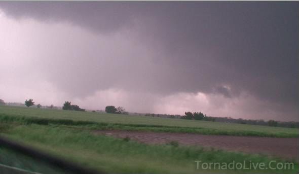
Pics from the last 4 Chases, Respectable Chasing Tour Company Purchases County Road in Kansas
Saw just about every chaser in North America, this last weekend, including Uncle Chuck south and east of Wakeeney at dusk on Thursday. He leaned his head out the window to look back for some reason, must have smelled the yahoos in the air! I hear the C. Doz has a hell of a nose for them! Met Bill Hark, Jason Persoff, Robert Bahloff on the turkey towerpalooza on Saturday...very nice guys. Sorry I couldn't answer your call Lanny, I was busy kicking myself repeatedly in the nuts. Did everyone grill burgers on the habachi or have a few cold ones in the lawn chair on that storm? Jeesh...
Initiation...towering Cu breaks the cap, east of my hometown Dighton, KSlast Friday May 23rd. Exactly, 1 year and 1 day after we watched another cumulus field south of Dighton tower up and break through!
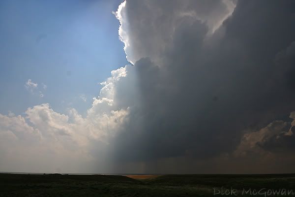
Ten minutes or so later...it doesn't get much better than this, I love structure!
Starting to rotate now, very high-based still, but the structure is breathtaking...I was hoping for a day like this, just like May 22nd last year!
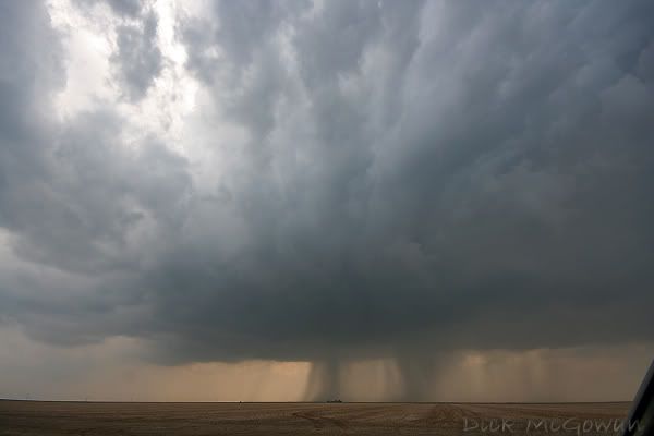
The cell is now about 1/4 mile or less to our west heading N/NE, this tail cloud formed quickly, and the LCL's were now lowering!
Just a few minutes after that tail cloud, a rotating wall cloud was just to our west, incredible, close rotation we were safely viewing it from. I tried reporting it on spotter network and that stupid google map balloon verification crap came up and my connection was lost on alltel in BFE Lane county.
We watched it cross Highway 4 and went east to get back to the north, and 3 tour vans (which I guess is owned by a textbook goofy, nerdy looking fellow), blocked the sudden line of chaser's only north road option for 4.5 miles (more later!). After resisting the urges of physical violence on them, we caught the storm further north and it would spit out brief funnels, still looking high based.
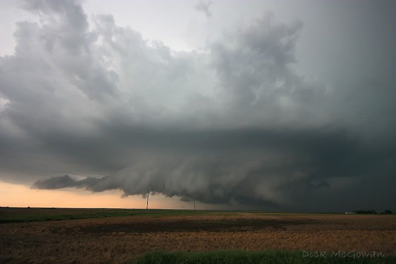
We keep flanking it when it gets too close, and the roads are getting pretty muddy and the storm is starting to look nasty and HP, scud fingers are literally on the ground, but weren't rotating.
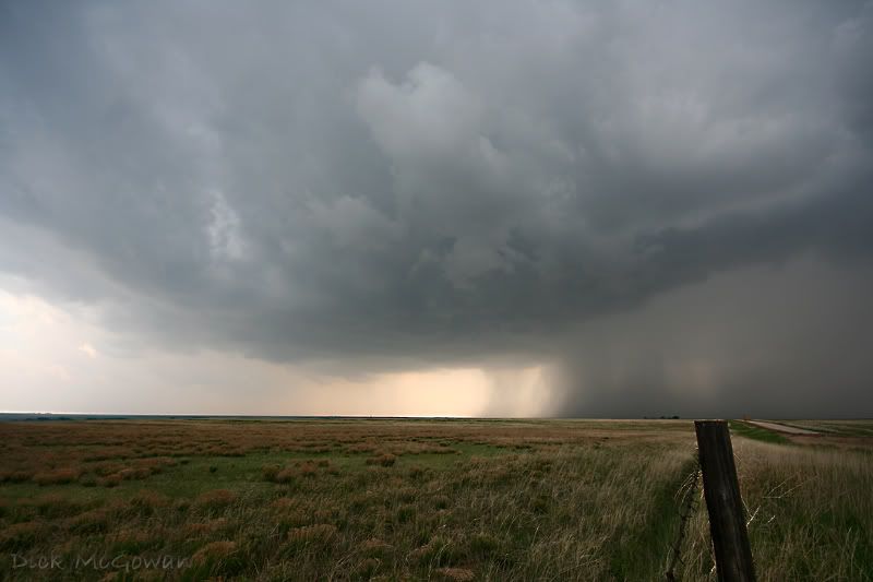
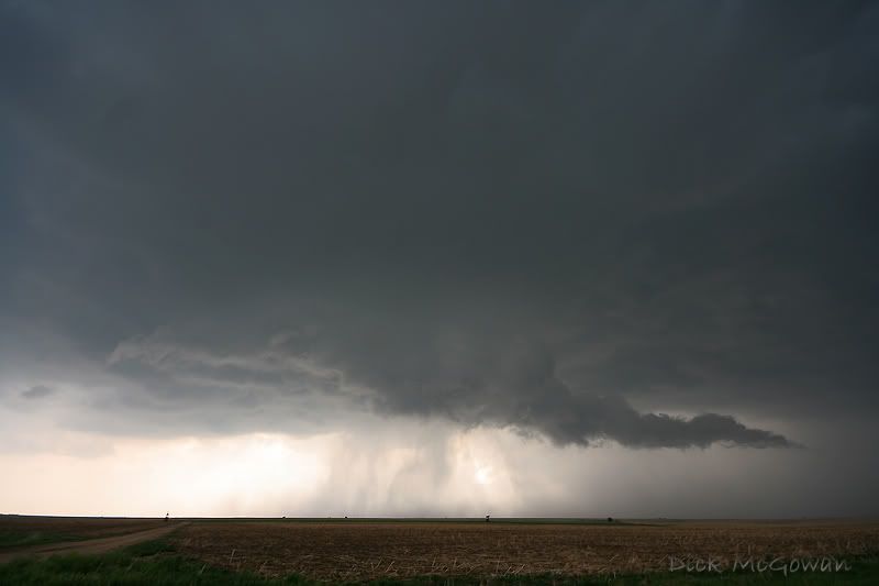
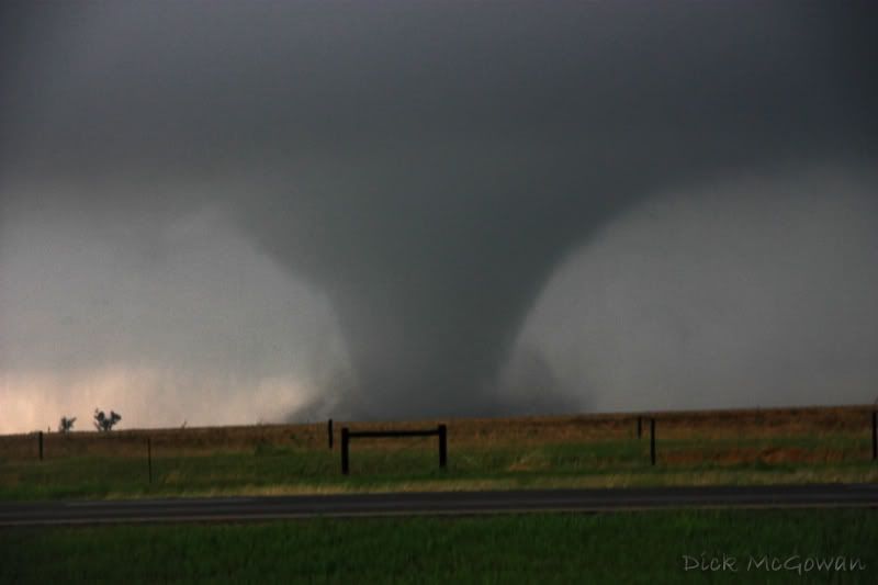
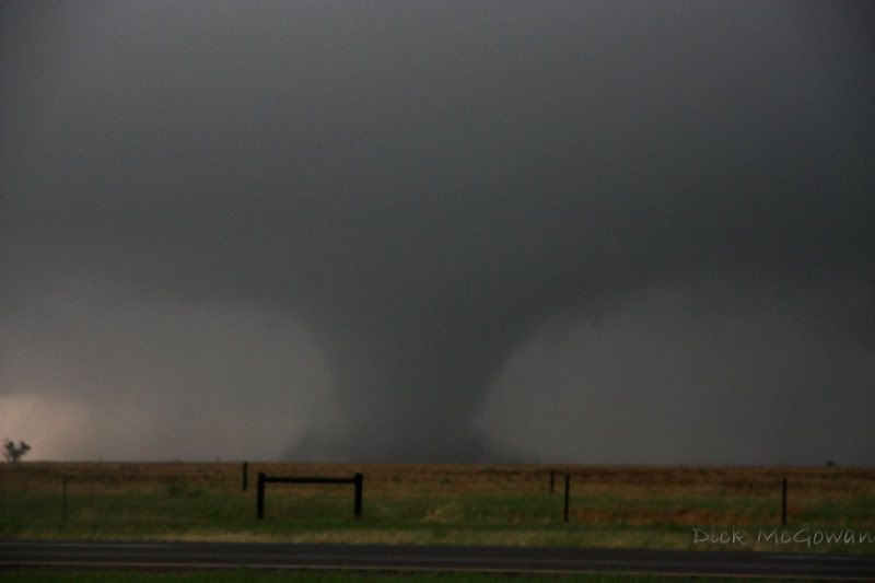
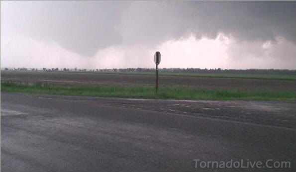
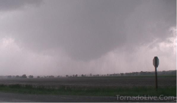
I was tired of driving on those roads and crossed paths with Jeff Piotrowski and Dustin Wilcox and asked them how the roads were he had just came on, and he told me not so good...but we took them anyways. Came across the damage path from the day before in a huge draw in the Smokey Hills that uprooted 100 year old cottonwood trees and damage to a farm, which we couldn't see too well. It's now hazy, foggy and we can't make out much structure to the storm, and now see that a tornado was reported right where we were 2 minutes prior. Figures...we saw no rotation, we leave, it goes nuts. We head north on another award winning gravel road that is allowing me to do about 40 mph before it starts to fishtail, and see Mr. Gene Moore and waive at him as we slide on by to I-70. Gene's a great guy, and a great chaser...down to earth. It turns out our baby smooth road doesn't have an onramp to get onto I 70, so just two more miles to Highway 40 and no more mud. HA! Highway 40 east of Quinter is gravel, so away we go into Quinter, seeing mounds of chasers with a horrible vantage point behind an onramp on I 70, and get on the ramp and I find a spot I think will allow us to view the tornado, if there was one. Rotation was looking incredible, and through the rain curtains to our almost pitch-black south is a cone funnel dancing around and it looks to curl up sideways, and is gone again.
Not a minute later, a huge cone is now visible to our south and is not moving side to side....I'll let the video talk from there.....and write more later as I am hitting the road for the next chaser party, van block-road festival, on some dirt road or highway somewhere on the Plains.
Below is a wall cloud on Sunday, with dead calm surface winds that allowed the outflow to take over shortly after. We saw a landspout 10 miles away and some good structure, before it "Illinois-ed" on us and looked cold, green and shelfy. Well worth it on the structure alone.
Initiation...towering Cu breaks the cap, east of my hometown Dighton, KSlast Friday May 23rd. Exactly, 1 year and 1 day after we watched another cumulus field south of Dighton tower up and break through!
Ten minutes or so later...it doesn't get much better than this, I love structure!
Starting to rotate now, very high-based still, but the structure is breathtaking...I was hoping for a day like this, just like May 22nd last year!
The cell is now about 1/4 mile or less to our west heading N/NE, this tail cloud formed quickly, and the LCL's were now lowering!
Just a few minutes after that tail cloud, a rotating wall cloud was just to our west, incredible, close rotation we were safely viewing it from. I tried reporting it on spotter network and that stupid google map balloon verification crap came up and my connection was lost on alltel in BFE Lane county.
We watched it cross Highway 4 and went east to get back to the north, and 3 tour vans (which I guess is owned by a textbook goofy, nerdy looking fellow), blocked the sudden line of chaser's only north road option for 4.5 miles (more later!). After resisting the urges of physical violence on them, we caught the storm further north and it would spit out brief funnels, still looking high based.
We keep flanking it when it gets too close, and the roads are getting pretty muddy and the storm is starting to look nasty and HP, scud fingers are literally on the ground, but weren't rotating.
I was tired of driving on those roads and crossed paths with Jeff Piotrowski and Dustin Wilcox and asked them how the roads were he had just came on, and he told me not so good...but we took them anyways. Came across the damage path from the day before in a huge draw in the Smokey Hills that uprooted 100 year old cottonwood trees and damage to a farm, which we couldn't see too well. It's now hazy, foggy and we can't make out much structure to the storm, and now see that a tornado was reported right where we were 2 minutes prior. Figures...we saw no rotation, we leave, it goes nuts. We head north on another award winning gravel road that is allowing me to do about 40 mph before it starts to fishtail, and see Mr. Gene Moore and waive at him as we slide on by to I-70. Gene's a great guy, and a great chaser...down to earth. It turns out our baby smooth road doesn't have an onramp to get onto I 70, so just two more miles to Highway 40 and no more mud. HA! Highway 40 east of Quinter is gravel, so away we go into Quinter, seeing mounds of chasers with a horrible vantage point behind an onramp on I 70, and get on the ramp and I find a spot I think will allow us to view the tornado, if there was one. Rotation was looking incredible, and through the rain curtains to our almost pitch-black south is a cone funnel dancing around and it looks to curl up sideways, and is gone again.
Not a minute later, a huge cone is now visible to our south and is not moving side to side....I'll let the video talk from there.....and write more later as I am hitting the road for the next chaser party, van block-road festival, on some dirt road or highway somewhere on the Plains.
Below is a wall cloud on Sunday, with dead calm surface winds that allowed the outflow to take over shortly after. We saw a landspout 10 miles away and some good structure, before it "Illinois-ed" on us and looked cold, green and shelfy. Well worth it on the structure alone.
Monday, May 26, 2008
Too much to post about...

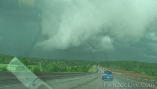
But here's a quick video and a picture...chased the last 4 days, had to sit out today or else Devin might have strangled me!
The yelling at the end is an inside joke between Reed and I, it's not how I usually act. We left that storm and flew south to the right mover where we intercepted in Hodgeman county. I was tempted to wait for the next storm to hit that boundary draped on I-70, but thought those storms started to congeal...wrong...it put down several more tornadoes on the storm to our south...along with a huge wedge that almost hit Doug Kiesling. He has some incredible video of it, which I think was shown everywhere.
I have more tornado video, including a distant anti-cyclonic elephant trunk and a big cone I'm gonna try and get up from the day before, along with several spinups from close range near my hometown of Dighton (actually Amy...on the same road (Turkey Red) as my ex girlfriend! HA!)
Video Capture from Thursday south of Wakeeney:
We saw a supercell headed for Greensburg and as we got closer were hearing reports of a violent tornado on the ground and the rotation was nearly on top of Greensburg. I got sick to my stomach and we FLEW there, and were hearing reports that the tornado was in the town...then later on that it "lifted" up before Greensburg. We were all nearly in tears and were saying prayers before hand and were getting there as fast as we could. I have some stills of the supercell that look like a halo from that updraft as it was going over Greensburg...does anyone know the TRUTH about Protection getting "wiped out?" I got a call from Daniel Unruh (the guy we picked up south of Greensburg last year) and he told me that he heard that...but his family was okay. (He lives in New Mexico now).
Anita- I hope you guys are okay...we were heading straight for Femaville when we heard to make sure... and saw that Greensburg was spared. I just couldn't believe what we were seeing....more later.
Tuesday, May 20, 2008
Mother's Day, KU Graduation, Chasing this Weekend
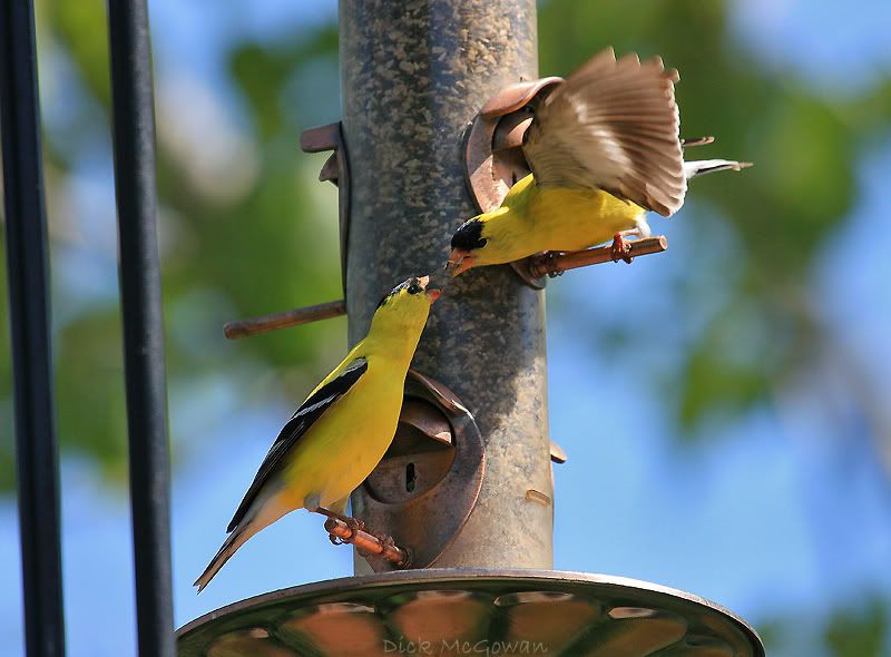
I haven't had time to post about Mother's Day, in which, I cooked my mother some authentic Mexican food (as it's the only thing I will cook) and took some pictures of a hummingbird and finches in her yard. What a beautiful day it was for Mother's Day after that front blasted through the day before.

And this past weekend, my girlfriend, Devin and I helped set up a party for her sister Rachel's KU graduation. On the way over there I was in a hurry and got a nice, hefty speeding ticket of $246, near my house on the backroads trying to make up time before it! I dropped Devin's mom and youngest sister off, while Kasey (oh yes, another sister of Devin's!) and I parked my car clear on 8th and Mississippi, and walked clear up to the top of the hill. I'm still pretty pissed off and could have choked some people who just had to move in front of me as she was walking by, but I snapped at least one good picture of Rachel! Rachel will be interning for 1 year before becoming a teacher! She definitely will not disappoint those who will be lucky enough to be in her classroom.

Looks like Doug, Derek, Jordan and I will be heading out to chase Thursday, Friday and Saturday and will meet up with Darin and Alexis sometime on Friday when they get back from Boston.
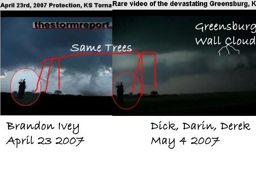
I also talked with Brandon Ivey because I noticed in his April 23, 2007 video that he shot those tornadoes in the exact same spot as we did for the Greensburg wall cloud.
I'll probably make more updates in the next few days, as the target area becomes more clear. We should be streaming live video again on TornadoVideos.Net and our website TornadoLive.Com all weekend long.
And this past weekend, my girlfriend, Devin and I helped set up a party for her sister Rachel's KU graduation. On the way over there I was in a hurry and got a nice, hefty speeding ticket of $246, near my house on the backroads trying to make up time before it! I dropped Devin's mom and youngest sister off, while Kasey (oh yes, another sister of Devin's!) and I parked my car clear on 8th and Mississippi, and walked clear up to the top of the hill. I'm still pretty pissed off and could have choked some people who just had to move in front of me as she was walking by, but I snapped at least one good picture of Rachel! Rachel will be interning for 1 year before becoming a teacher! She definitely will not disappoint those who will be lucky enough to be in her classroom.
Looks like Doug, Derek, Jordan and I will be heading out to chase Thursday, Friday and Saturday and will meet up with Darin and Alexis sometime on Friday when they get back from Boston.
I also talked with Brandon Ivey because I noticed in his April 23, 2007 video that he shot those tornadoes in the exact same spot as we did for the Greensburg wall cloud.
I'll probably make more updates in the next few days, as the target area becomes more clear. We should be streaming live video again on TornadoVideos.Net and our website TornadoLive.Com all weekend long.
Friday, May 16, 2008
Rounds 2 and 3 in SE KS.
EDIT: I wrote this last Friday, but couldn't get the images to upload...
Chase Report for May 10th HERE.
Some pictures and video captures below as I have become lazy at writing as of lately, but the chase report is in the link above.
I'm done with school till June 2nd when my summer class starts!! What a crappy chase year this has been as of this writing. 2006 is starting to look like a dream season compared to 2008 (it was good to us, with 4 successful tornado days, which was a HIGH number).
Storms have been in the same area the last few chases, with the same disorganized looks to them minus the Oswego supercell, which of course was about to probably mimic the Picher OK storm before being engulfed by it. Tuesday never looked good at all, with one of those elongated banana surface lows (which rarely produce anything noteworthy), with the better low level winds 200 miles east of the boundaries. We took a look at SPC's mesoanalyis and wondered how about 50 chasers could be parked, waiting for initiation with weak due west 850's. Hell if I see SW 850's which are notorious boundary layer moisture killers. I know chances of seeing a tornado are slim if not blue, clear skies.
On the other hand, GFS is now breaking down the ridge and in general agreement with the ECMWF of bringing a powerful disturbance towards the middle of next week and will probably last through the weekend.
I noticed some hits from an Australian storm forum for the live video streams, so I added more on the right that I could find.
In chaser news, storm chaser Brian Barnes was arrested for I guess not leaving an area he was safely reporting to the NWS of. Story made drudge and other news outlets. And Roger Edwards takes his usual indirect cheap shot at someone....this time at Shane Adams for falsely reporting a tornado that I guess wasn't, and accused him of whatever. It would be quite the shocker to see Roger's balls finally drop, man-up and just name that person instead of pussy-footing around leaving others to guess or assume.
Jim Reed intercepted an amazing landspout out near where I used to live outside of Leoti, KS (I think). The video showed him on GMA running towards it, because it was nearly stationary and he wanted to get an amazing up close photo. Of course if that were Reed and Joel or anyone else some don't approve of, they'd get labeled a yahoo. It makes no difference to me, as I'll ride my bike into a tornado dressed up as a clown if I was in the mood for it. I used to see these pompous, narcissistic bastard's points in how it would potentially make the chase 'community' look bad. Then I realized that was just a smoke screen for envy, and that's what made the chaser community look bad, was this seniority select few of "veteran" chaser's hierarchy of horse shit. Embarrassing really... childish, pointless, dumb. People will see a certain group of people the way they've always viewed them as, not much will change that. It's like the Godfather-mafia drama, only without the violence, the threats without acting out upon, and an overrated cast from Revenge of the Nerds. I could have written that out like an insecure, two-faced author would have, but I'd risk my integrity of those who respect the person I'm not. In case you haven't figured it out yet, I just don't give a shit about the toes I step on.
Sunday, May 11, 2008
May 10th, 2008 Chase Account
I mentioned on Friday night to Eric B'Hymer that SE Kansas was my target and I thought the models were not not forecasting enough instability near and just to southeast of the surface low, with lots of PVA from the vort max just behind it and also better directional shear (didn't end up being that way for directional shear). I laughed when I woke up at around 9 a.m. and saw but a slight risk for hail for much of the target area. I called Darin to see if he wanted to go, he called me back and thought the same thing. By the time I got to Lawrence a tornado watch was just issued (wtf?) and we headed south to pick up Eric in Iola.
Mike Parker, Eric, Darin and I chit-chatted for a bit...Mike opting out for a family barbecue he couldn't get out of. We headed east to Yates Center, filled up, then went south as storms started to fire in Sumner county, KS in good instability but in due west surface winds! We weren't about to attack these storms in due west surface winds and waited for them to hit the better shear/air where we were at. We parked in the EXACT same spot we did on May 1st, south of Neodesha, watching probably one of the most spectacular updrafts I have ever seen...rock solid, towering just to our west in Elk county. Still in the shit air, we headed east on US 400 and I think were on the 59/400 junction where we filmed a lowering here:
Not tornado-warned yet, and we see nothing but rising motion in the scud, and we floor it east to stay up and ahead of the storm. The NWS calls Darin (not really sure which office) and asks us what we see, and the storm looks very HP and Darin says it's looking kind of outflow-ish. Ben Prusia passes us going the other way (we see Ben everywhere now!) and I almost thought he was ditching this storm for the one coming in from the SW...
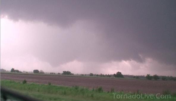
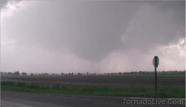
We head into Oswego and are getting hit with a lot of rain, and we notice a HUGE RFD cut to our north and quickly get east of town where a cone funnel is now visible in the rain. We're all looking back as Doug, Jordan, and Mike are following us as well, and note scud being pulled in hard and a small debris cloud visible just to our NW. Darin hands me the camera as I look for a road to pull off of, and film just as it lifts back up, and within the next 5 minutes, completely occludes to the south which I thought was very strange.
In the meantime, no more than 20 miles to our south, there is a violent wedge on the ground, in which this supercell develops out of nowhere, and engulfs our storm. I have no doubt our supercell was minutes away from doing the same thing by the way it looked, if it hadn't have been for this one.
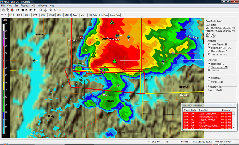
So now we are playing the "punch the core from hell" game from the north while this supercell to our south is doing 50 mp to the E/ESE...here's a GR3 capture. Thanks to Dean Baron on Stormtrack for it:
We are the green icon with the arrow pointed down just east of Columbus:
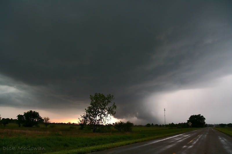
Long story short, we hydroplane at least 3 times, encounter golfball-size hail and see lots of baseballs along the interstate, and finally go south on US 71 where we encounter probably EF-1 damage north of Neosho with major powerlines down. Just to the east of it, we see probably one of the most amazing rotating wall clouds and possible tornadic circulation underneath it (as this meso is still causing damage but from our vantage point we can't see the ground). We debate for about 5 minutes whether the lines were hot or not and we let someone else drive over them before we did. We head east on some county road where we see more damage and people outside. We yell and ask if they need help and they say they're okay, so we continue navigating through the damage path noting huge trees uprooted and some houses with minor damage.
More later...I'm running out of time with 2 finals today. My target for tomorrow is Cherokee county, KS again in extreme SE KS.
Mike Parker, Eric, Darin and I chit-chatted for a bit...Mike opting out for a family barbecue he couldn't get out of. We headed east to Yates Center, filled up, then went south as storms started to fire in Sumner county, KS in good instability but in due west surface winds! We weren't about to attack these storms in due west surface winds and waited for them to hit the better shear/air where we were at. We parked in the EXACT same spot we did on May 1st, south of Neodesha, watching probably one of the most spectacular updrafts I have ever seen...rock solid, towering just to our west in Elk county. Still in the shit air, we headed east on US 400 and I think were on the 59/400 junction where we filmed a lowering here:
Not tornado-warned yet, and we see nothing but rising motion in the scud, and we floor it east to stay up and ahead of the storm. The NWS calls Darin (not really sure which office) and asks us what we see, and the storm looks very HP and Darin says it's looking kind of outflow-ish. Ben Prusia passes us going the other way (we see Ben everywhere now!) and I almost thought he was ditching this storm for the one coming in from the SW...
We head into Oswego and are getting hit with a lot of rain, and we notice a HUGE RFD cut to our north and quickly get east of town where a cone funnel is now visible in the rain. We're all looking back as Doug, Jordan, and Mike are following us as well, and note scud being pulled in hard and a small debris cloud visible just to our NW. Darin hands me the camera as I look for a road to pull off of, and film just as it lifts back up, and within the next 5 minutes, completely occludes to the south which I thought was very strange.
In the meantime, no more than 20 miles to our south, there is a violent wedge on the ground, in which this supercell develops out of nowhere, and engulfs our storm. I have no doubt our supercell was minutes away from doing the same thing by the way it looked, if it hadn't have been for this one.
So now we are playing the "punch the core from hell" game from the north while this supercell to our south is doing 50 mp to the E/ESE...here's a GR3 capture. Thanks to Dean Baron on Stormtrack for it:
We are the green icon with the arrow pointed down just east of Columbus:
Long story short, we hydroplane at least 3 times, encounter golfball-size hail and see lots of baseballs along the interstate, and finally go south on US 71 where we encounter probably EF-1 damage north of Neosho with major powerlines down. Just to the east of it, we see probably one of the most amazing rotating wall clouds and possible tornadic circulation underneath it (as this meso is still causing damage but from our vantage point we can't see the ground). We debate for about 5 minutes whether the lines were hot or not and we let someone else drive over them before we did. We head east on some county road where we see more damage and people outside. We yell and ask if they need help and they say they're okay, so we continue navigating through the damage path noting huge trees uprooted and some houses with minor damage.
More later...I'm running out of time with 2 finals today. My target for tomorrow is Cherokee county, KS again in extreme SE KS.
Monday, May 05, 2008
Greensburg Anniversary Video
Thanks to Reed Timmer for uploading these for me. Darin, my girlfriend Devin (hi Devin!) and I watched Brian Schodorf's documentary on PBS last night, which was pretty good. More later, I'm still up at 2 a.m. finishing some maps for GIS on tornado tracks in Johnson County, KS...cool stuff.
May 4th is a special day for me. It marked my first ever storm chase (2003) which Derek and I saw a deadly F-4 rip through north K.C. That's the day that got me hooked. We had no clue what we were doing back then.
Here is nearly 40 minutes of our Greensburg video from start till finish of Friday, May 4th 2007. A day I probably talk about too much and think about too much, but a day that changed me forever. God Bless the residents and those who truly care and are helping them out.
Part 1:
Part 2:
Part 3:
Part 4:
Friday, May 02, 2008
Pics from yesterday


Too lazy to post a chase report, but these are near Fredonia and Lafontaine, KS. Storms were elongated, linear-looking after first initiation...we blew off the NE OK storms and hung out and talked to about 10 different locals who stopped to chat. Big circus in Neodesha, KS with the TIV and DOW's with the whole town seeing the show. Ran into Randy Hicks there at the gas station as well...and Chris Rice, Steve Polley, Tyler Constantini, Jay Cazel and others. Ben Prusia also stopped to chat near Lafontaine as I laid in a corn field snapping photos lol. It was amusing to watch people haul ass after a shitty supercell we ditched, and then 5 minutes later turn back around and head the opposite way. Maybe one day I'll see a tornado again, it's coming up close to a year...good thing I'm not big on those, or I'd be depressed!
More tomorrow.....(the ones I didn't blow out or have 800 ISO on!)
Subscribe to:
Posts (Atom)